After the last update, SkyDemon automatically switches to a very SafeTaxi’ish display on my iPad. Seems very useful, at no extra cost at all.
SkyDemon may not be the primary tool of choice for low vis ops, but getting lost taxiing in big airports is not limited to low visibility, not for me anyway.
Oh, alioth just mentioned that also.
I have just ordered the 660, from Peter Mundy. It comes with Safetaxi bundled. I am not sure about other stuff; anything else is a bonus. I will report on it in due course.
I think quite a lot of people are doing georeferenced airport plates from the national AIPs. I noticed these on EVFR also. Providing these is not a vast amount of work because they have the coordinate grid printed on them so any “slave” can do it, with a suitable setup which verifies the coordinates as you move the cursor about (I calibrate a fresh set of European VFR charts every year and the calibration is checked by overlaying a 30 minute grid and checking it lines up with the grid printed on the chart). Also the liability is hardly great because you aren’t likely to kill yourself while taxiing and you will visually verify the holding point at which you arrived. The things which are hard to identify are taxiways.
Peter wrote:
I can do that anytime in 10km+ vis (and have done many times)
I have too – the thing is at larger airports, the signage and indications and route might be obvious if you’re 20 feet up in an Airbus flight deck, but if you’re in a GA plane (worse still, a tailwheel aircraft with poor forward visibility with the tail down) it can be a struggle. Especially at night. I remember one flight I had in the US in the club’s Bonanza returning from the “big” airport in Austin just a sea of blue taxiway lights everywhere when you looked out.
Skydemon now has all the AIP ground charts in which has been a great help :-)
Database pricing for all Garmin portable devices is here: https://fly.garmin.com/fly-garmin/support/pricing
Annoyingly, they only list US prices, but I can confirm from my invoice that the US price broadly translates into GBP (~2% difference).
The first price is for a single, one-off update. The second price is for an annual subscription to the database.

The pricing for SafeTaxi is the same as for a full annual subscription, which is far better value and offers the full suite of databases.

I think the GBP 40 for SafeTaxi, referred to earlier in the thread, was actually the “Premium” upgrade option for Garmin Pilot, which is in addition to the basic annual subscription price.
Garmin Pilot Europe Standard subscription:
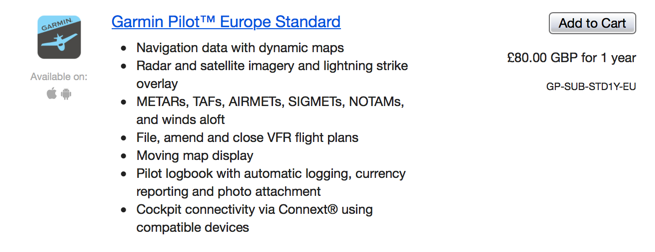
Garmin Pilot Europe Premium Upgrade subscription:

Note: Garmin FliteCharts = geo-referenced AIP plates
Its not just pilots I remember having to push back a DC-8 onto the taxiway as due diverts the apron was rammed and bugger me it was hard to find.
Ah! OK. Thanks.
@Emir: with low visibility operations in use and the RVR falling below 400m, you need an LVTO approval to taxi, depart or land an aircraft in such conditions. Do you have an LVTO approval? Or do you get away with it? It is something that got in there (the LVTO approval for less than 400m RVR) with the new EASA rules and hopefully, some day, will be adjusted to not be applicable for non-commercial operations.
I am looking at the Garmin Aera 660 and running Safetaxi on it.
Does anyone know the pricing (I can’t find it)? The Garmin description states “The aera 660 aviation portable comes preloaded with detailed flight mapping, terrain and obstacles alerting, U.S., European and Canadian SafeTaxi® charts” so it looks like it is initially included.
Does the Safetaxi feature get disabled after the database expires?
If it really costs 40 quid a year, that’s great value.
Is this on all airports in SD?
SD covers a lot of countries. In the UK, licenced airports are included and also in other countries.
At optional extra cost also provides these for many unlicensed and/or foreign airfields using Pooleys or AFE.
Another free option includes the French VFR approach charts from their AIP.
I’ve used these for taxiing at larger airports and at night too.