eurogaguest1980 wrote:
INS chips are so inexpensive and accurate I am surprised that they have not been more widely incorporated into GA avionics.
In my experience that is not true. The chips I have used drift quite a bit. It is fine for many applications where you have a constant method to stabilize the system. But I do not think such commercial chips would allow building an INS which will work for an hour or longer especially in bumpy air. If you fly into an area with a wind component this acceleration will be ever so small compared to vibration, bumpy air etc and very difficult to measure.
Why not discontinue the use of headings completely and use course for everything? Fine so long as you have GPS…
This is all about what-if-ism. If you rely, say, on a VOR, you will have to take into account the magnetic field of the earth, as far as I understand the underlying operational principles. So even if the VOR was putting out true courses instead of magnetic ones, it might not be indicating correct at your position, which would be even more confusing than it is now. But if you are willing to trust GPS alone you can switch to GPS tracks and forget about the magnetic field.
In Europe it’s a philosophical question, as the difference is so small.
The G1000 use manual warns that it should not be relied upon for nav North of latitude 60N or South of latitude 60S.
Further North or South of each, IIRC one uses a grid which I remember learning how during my IR theory but is one of those things I’ve never used since.
Well, obviously one cannot rely totally on GPS (because it can be easily jammed) unless there is a backup.
The “problem” is that – in Europe, for sure – GA is valued at “zero” and airlines all have INS. But, fortunately for us, most bizjets don’t have INS, and their owners have a lot of political power (especially as all top level politicians fly in bizjets everywhere).
So this change will probably not happen anywhere where there isn’t a backup system suitable for non INS traffic, and that would have to be ATC radar.
So it could be done in Europe. And probably Canada made the same calculation.
Indeed, solid state gyros are not good enough for navigation by a factor of 100x to 1000×. Various previous threads e.g. here here here here.
UdoR wrote:
This is all about what-if-ism. If you rely, say, on a VOR, you will have to take into account the magnetic field of the earth, as far as I understand the underlying operational principles. So even if the VOR was putting out true courses instead of magnetic ones, it might not be indicating correct at your position, which would be even more confusing than it is now. But if you are willing to trust GPS alone you can switch to GPS tracks and forget about the magnetic field.
I don’t see what you’re referring to. There’s nothing in the operating principle of a VOR that depends on the earth’s magnetic field. A VOR would work just as well if the earth didn’t have a magnetic field at all.
UdoR wrote:
In Europe it’s a philosophical question, as the difference is so small.
In central Europe, yes. Not in Scandinavian or Finland.
gallois wrote:
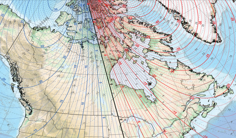
The G1000 use manual warns that it should not be relied upon for nav North of latitude 60N or South of latitude 60S.
What G1000 variant is that? For the Cessna 172S, the limitations are:
North of 72°N or south of 70°S, except
North of 65°N between 75°W and 120°W.
North of 70°N between 70°W and 128°W.
North of 70°N between 85°E and 114°E.
South of 55°S between 120°E and 165°E.
Airborne_Again wrote
" What G1000 variant is that? For the Cessna 172S, the limitations are:"
IIRC it was from a very early G1000 manual for the DA40D.
The 2014 DA 42 manual gives:
“Warning, because of variation in the earth’s magnetic field operating the G1000 within the following areas could result in a loss of reliable attitude and heading indications. The ones you have listed plus.
North of 72°N latitude at all longitudes
South of 70° S latitude at all longtitudes
Maybe the Garmin lawyers were a bit more conservative in the early days.
This comes from the Garmin G1000 user manual for the DA42 dated 2014
gallois wrote:
The ones you have listed plus.
North of 72°N latitude at all longitudes
South of 70° S latitude at all longtitudes
I listed them, too.
Maybe the Garmin lawyers were a bit more conservative in the early days.
This comes from the Garmin G1000 user manual for the DA42 dated 2014
The POH page I referred to was also revised in 2014, so maybe indeed there was a general change in limitations (and/or software) for the G1000 in that year.