The swiss GAFOR is AFAIK only available through paysites like flugwetter.de or skybriefing.ch. Alternatively, you can get it for free at the (swiss) airport using, incidentally, skybriefing.ch with the “airport login”.
Peter wrote:
I wonder how many people do fly into the wrong canyon and find it is too narrow to turn around, too late?
One every couple of years. And it happens to (in)famous people too.
Thanks for that.
Skybriefing has a free 14 day trial, so if austrian control doesn’t work out I will try that and, as you say can get the latest in Lausanne. They sounded friendly there.
chrisparker wrote:
A few seconds of video
Nice … with this rain and cloud bases lowering 
@Teal , your plan to stop in Lausanne before going through the Alps sounds good.
I would start monitoring the generic Alps weather some days before the flight. You need to have favorable weather for the Alp crossing.
Check the QNH of airfields north and south of the crossing. If there is a significant difference you can expect turbulence and up/downdrafts.
As already stated by @tomjnx the GAFOR forecasts are not publicly available. I have a paid account on the DWD website (German Weather Service) and can download the charts there. This is todays GAFOR:
There is a Swiss meteorologist active here: @Mooney_Driver
You could ask him to help you assessing the weather?
I remember I’ve seen an overview of the Swiss GAFOR routes with the waypoints an minimum altitudes, but I can’t find it anymore.
I remember I’ve seen an overview of the Swiss GAFOR routes with the waypoints an minimum altitudes, but I can’t find it anymore.
Found them; they’re in the AIP section 4.4: http://eaip.austrocontrol.at/all/ls/160107/eAIP/2016-01-07/html/eAIP/LS-GEN-3.5-en-CH.html
Jacko wrote:
It’s nice, and sometimes essential, to use up-draughts to augment aeroplane performance
When I was living in the US, I had a Cessna 140 with a C85 engine and a cruise prop. I flew it in the Rockies on several occasions. I often ridge soared to gain altitude (or circled in some of the very strong thermals!).
It probably wasn’t very smart, but I was still in my 20s and invincible!
Thanks @lenthamen
Very useful, I have now managed to find webcams for the entire route, so am slowly piecing it together.
Google earth and google terrain are very useful for going through the route.
I will setup the flight plans prior to going and then activate them as necessary. My intended route is UK to Abbevile (for Schengen), then Lausanne for weather info and customs (customs also available in Locarno) then Locarno via the Simplon Pass.
Weather backup is round the south via Nice, stopping at Albenga – have heard good reports about it there.
The weather next week isn’t looking so good but will have to see….at least I’ve got a plan.
There is so much good stuff on the internet, except for the Swiss GAFOR chart..!
Got back today, all went well.
Lausanne worked well on the way out. This meant I was fresh to fly the Alps and was able to do it first thing in the morning.
On the way back flew Locarno Simplon pass route then to Abbeville, then Popham for UK Customs, then to home strip.
Got GAFOR weather from Skydemon (used their monthly £12 subscription, which can be bought a month at a time.) Also bought some flight plan credits with them, so was able to route plan, flight plan and do GARs with an Ipad.
Used Runway HD for moving map as I prefer the mapping. It’s also good to get a good road map with terrain on it. You can then go through the flight in your mind before flying it. Google terrain is also good.
Much of the routing was similar to the OP, though we did manage a trip to the Neufenen Pass as well.
Learning points…many!
But key ones…
It’s all about the weather…obvious but true. Used the BBC Met Office synoptic chart, an American site (free) for 5 and 10 000 ft winds and XCweather (ios app) for weather. It also has, in the paid version I think, a link to webcams for a airfield. So very useful for VFR conditions (be careful of the date stamp on a wbcam ie make sure it is valid and not an old image) I also use the Europe lightning map on Allmetsat and XCweather.
Density altitude..it’s been hot the last couple of weeks. Has a big effect on engine, as well as aircraft performance.
Set altitude gates for climbing. Sometimes you need more track miles to get the climb in.
Never box yourself into a corner, always have a way out. Make sure you have got space to turn in a valley or to do a 360 to get a climb in.
In summary, I have wanted to make this trip for a long, long time. Finally it happened and it was worth the wait. Will definitely go back for more.
Congratulations to your achievement! Flying in the alps is highly rewarding when you respect the weather. The GAFOR route forecasts give a good indication if the crossing of the passes is possible.
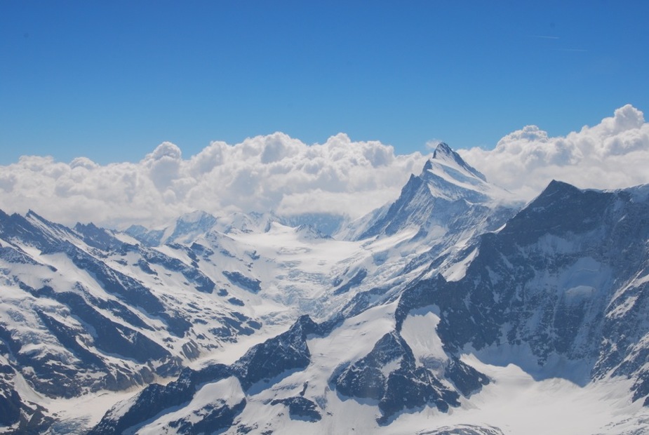
This picture I took in June 2015 shows the area north of the passes Grimsel, Nufenen and Gotthard. Beautiful weather on the north side but masses of clouds to the south, a clear X (= closed) for a VFR flight on these routes.