LeSving wrote:
Well. When steve called final, he should be way ahead of the TMG, but was in fact more or less right above him. It would be interesting to hear the TMG pilot’s version of this and see his exact path.
His statement over the radio was that he was flying at 500 feet or so parallel to the Lippe, practicing low flying ‘as required by his club’. He confirmed he had no intention of landing at Hamm. He didn’t make any statement as to why he never made any radio calls, especially not when he heard me calling base and final 06. As I previously said, I’m sure that he took off on a westerly runway and simply didn’t realise that Hamm was landing the opposite direction, thus putting himself into conflict. His confirmation bias led him to believe Hamm would be landing from the east and wouldn’t be a factor. Indeed, had he just said that, I would have said ‘fair enough, we all make mistakes, let’s learn from it’ but unfortunately he didn’t…..
Jacko wrote:
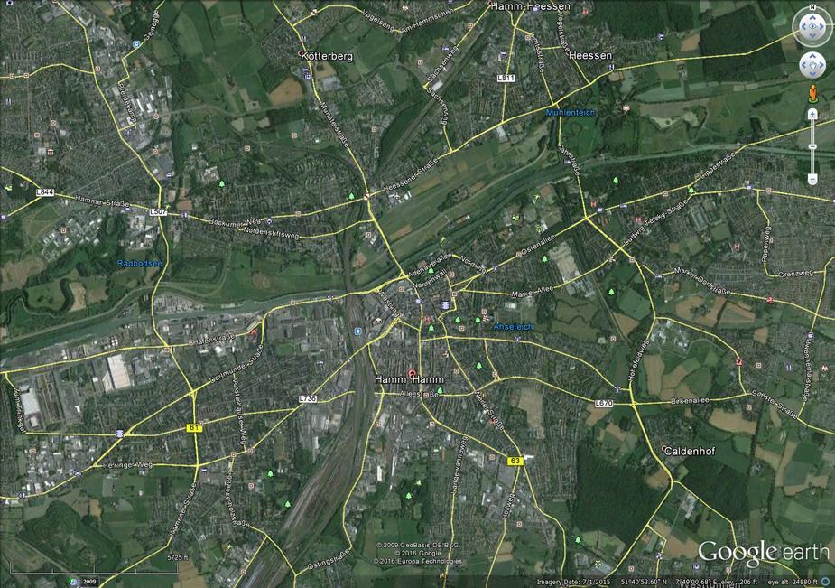
Yes, looking at Google Earth I would say that the green corridor north of the river and canal are definitely not a “congested area” of the city of Hamm. In that strip of land I can see a lake, a park, some fields, a sewage treatment farm, the airfield, and the King’s Bootshaus hotel, but that’s about all. But this GE image may be out of date and it may all be houses now. Have a look and see what you think:
I suppose it depends what you call a ‘congested area’. Article 255 of the ANO 2009 defined a congested area as being ‘any area of a city, town or settlement which is substantially used for residential, industrial, commercial or recreational purposes’, I’m pretty sure Germany will also have a similar definition, haven’t found it yet.
So, bearing in mind that the harbour is used substantially for shipping in goods, that there are boat houses for rowing clubs, that the path along the canal is packed with pedestrians and cyclists, you can argue that the canal is substantially used for recreational, commercial or industrial purposes. The same can be said for the lake and fields, especially on a day like Sunday when people were out in their droves walking the dog / pushing the pram / sailing model boats.
With regards the pictures on Google Earth – they are from 2009 so out of date, some of the locations you are referring to also now include additional housing, a large car dealership has extended his inventory storage area into that green strip plus some additional allotments have been created. At the same time, walk ways have been created for pedestrians who want to wander along the canal or for anglers to go fishing, but it is true that there is still a marked ‘green corridor’ splitting Hamm into ‘north and ’south’ on the western approach to Hamm Lippewiesen because we still want a place to be able to put down safely in case of EFATO after taking off on Runway 24.
To say that this corridor is the justification for allowing low flying is a bit far fetched……
Well. When steve called final, he should be way ahead of the TMG, but was in fact more or less right above him. It would be interesting to hear the TMG pilot’s version of this and see his exact path.
Well you could argue in favor of the glider pilot that he may have tried to stay south of the published path. Comparing Steve’s GPS map with the AIP, it seems that Steve flew an extended base over both of these rivers – the Lippe in the north, and the Datteln-Hamm-canal in the south – while the published base-to-final turn of 06 stays well north of the Lippe, east of the northward bend of the Lippe or the lake, respectively. So, in theory, the GPS path of the glider would not have touched the published path.
That doesn’t make flying there and at that altitude any better.
Steve,
Yes, looking at Google Earth I would say that the green corridor north of the river and canal are definitely not a “congested area” of the city of Hamm. In that strip of land I can see a lake, a park, some fields, a sewage treatment farm, the airfield, and the King’s Bootshaus hotel, but that’s about all. But this GE image may be out of date and it may all be houses now. Have a look and see what you think:
It seems from your GPS trace in post #01 that you did fly south of the river “over the town of Hamm” by a hundred metres or so, well outside the published path but no, I can’t say you’re “at fault”. However, in the light of your unfortunate experience, I’d be inclined to turn final soon after crossing Nordenstiftsweg. I think that would be a more positive reaction than shaking a stick at the other guy, but hey, it’s up to you.
But the horrid glider pilot didn’t fly across the published final approach path.
Has the published circuit pattern been posted here? I certainly understand the yellow line drawn in post #1 to be crossing the final approach to runway 06 at Hamm. I don’t even get how you could seriously argue that flying that track at 500 AGL would NOT put you in the vicinity of the aerodrome.
I wouldn’t argue in this case with the overflying height of built-up areas, because that rule wasn’t written to prevent collisions.
SERA 3025 on the contrary clearly was written to prevent situations exactly like the one we’re talking about here.
Edit: here is the approach plate:

Jacko wrote:
But the horrid glider pilot didn’t fly across the published final approach path. Steve’s path overshot the actual runway axis. I’m not throwing stones, we’ve all done that, just saying what we see on the GPS trace.
Sorry, you’re missing the fact that the circuit I flew is what ALL local pilots follow for noise abatement – if any come to Hamm, I always brief them on this. The Motor Glider Pilot is local and knows this….. Please don’t try to put the blame on me for following our internally agreed circuit – which we are trying to have the DFS accept and publish; However, more importantly, the point at which the collision could have occurred was directly in the published circuit, on final so please retract that statement that the glider did not fly across the published final approach path because he DID.
if you’re going to quote SERA in defence of the other guy, please tell me how he was conforming to SERA 5005:
(f) Except when necessary for take-off or landing, or except by permission from the competent authority, a VFR flight shall not be flown:
(1) over the congested areas of cities, towns or settlements or over an open-air assembly of persons at a height less than 300 m (1 000 ft) above the highest obstacle
within a radius of 600 m from the aircraft;
Looking at the above, how can you ‘perceive’ that he was legal to fly through the middle of a built up area at that height – or doesn’t a river flowing through a city count as a built up area? If that’s the case, at what point does a brook, a stream, a pond or a lake suddenly become ‘not part of a built up area’?
Additionally, as you’ve been studying the circuit, perhaps you should study the AIP more closely and you will see it clearly says ‘the town of Hamm shall not be overflown below 2000 feet MSL’. Two statements which clearly ban low flying aircraft yet you would have me believe he was legal to fly in that manner?
Finally, the manner in which we (by this I mean all local pilots) fly the circuit is in this manner because it keeps us over the industrial area and away from residential areas to the west of Hamm on base; it reduces noise pollution for residents but is approximately 0,1NM wider than published. For info, we have actually requested having the official AIP changed to ensure all pilots follow it but the DFS doesn’t want it changed. Nevertheless if you believe I am at fault because I turn 0,1NM wider out onto final, then fair enough……
But the horrid glider pilot didn’t fly across the published final approach path. Steve’s path overshot the actual runway axis. I’m not throwing stones, we’ve all done that, just saying what we see on the GPS trace.
It’s also a matter of opinion as to whether the “vicinity” of a private aerodrome extends nearly two miles from the ARP for the purposes of SERA.3225.
Certainly, that rule is widely ignored in (dis)respect of small airfields. Glenswinton has been on the NATS charts for about five years, yet we often have fast jets, Hercules, light aeroplanes and helicopters blundering overhead at or above 200 agl. Maybe we should also put our rifle range on the charts, that might do the trick…
It could also be argued that the river and canal form an essential corridor for en route microlights and similar aerial trash wishing to avoid overflying the city of Hamm. In which case a thoughtful airman landing on Runway 06 might offset his final turn a few hundred feet to the north, rather than swinging south of the river.
I’m not criticising Steve, just saying that it might be worth trying to learn from the encounter and fly a tighter circuit in future, rather than swearing at the (allegedly) dozy TMG jockey.
Jacko wrote:
the other pilot who, technically, may have had the right of way
I don’t think you can argue that by any stretch. As I have pointed out further up, the relevant SERA rule having been breached here isn’t about the general collision avoidance rules in 3210 (aircraft coming from the right, overtaking etc.) which you cited, but rather this:
SERA.3225 Operation on and in the vicinity of an aerodrome
An aircraft operated on or in the vicinity of an aerodrome shall:
(a) observe other aerodrome traffic for the purpose of avoiding collision;
(b) conform with or avoid the pattern of traffic formed by other aircraft in operation;
…
Flying across the final approach if you’re not landing at an airfield can not be regarded as “conform with the pattern”, and neither is it “avoid the pattern”. It’s a plain and simple breach of the rules and of good airmanship.