I was bored tonight, so I did some aviation-related coding. The end result: A KML file with all Italian aerodromes (including airfields, UL fields, etc.). Detailed aerodrome info is contained in the placemark description.
Unfortunately, I will probably not be able to share this gathered info, due to the utilized data source. But nevertheless, I thought it was interesting and shows what can be done in just a few hours by combining the right tools. (I can give pointers how to DIY if anyone is interested.)
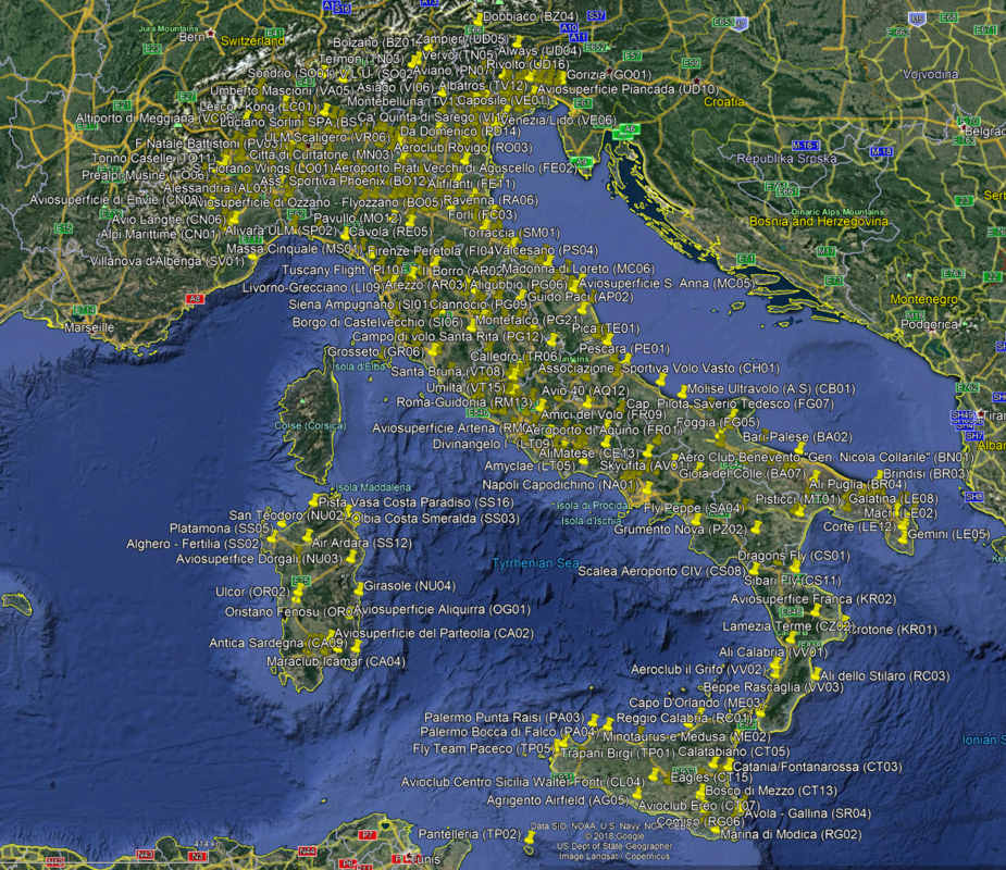
The end result is shown below in Google Earth:
Presumably you found a database containing airport coordinates and converted it into KML (or some such) and then it can be uploaded to google earth.
There is a number of them around but most aren’t public domain 
@Peter Yes, correct, that’s the problem unfortunately.
The code scrapes a large set of web pages, extracts and aggregates relevant content, and converts them into an intermediate tabular format, which can be stored in a database, CSV file, etc.
From this representation it is straightforward to generate a KML file, for import into Google Earth Pro for easy viewing. The cool thing is that the description of the place mark can be any HTML, so I added the scraped detailed aerodrome info. If you click on the place mark, there’s a pop-up with this info in table form.
I heard there is an ICAO database of airport codes and their coordinates, but apparently it is not quite complete… Eurocontrol have another one, for B2B customers.
It seems that everybody who has done this type of project has been collecting data from all over the place. And everybody else collects data from them 
My data source is hand maintained to my understanding, and a well-known information source for GA in Italy. (They also release their info in book form.)
So it’s Italy-specific, but covers all the little airstrips (aviosuperficie, campo di volo) as well, not just airports with an official designator.
IIRC, overall the KML contains more than 500 entries. Obviously, in the screenshot above, Google Earth shows only a subset at this zoom level.
On that note, a similar thing could be done without too much effort for France, extracting info from the official French VACs in PDF form, and perhaps adding unofficial ones from sites like BASULM.
Extracting the info is one thing, but licensing prohibits all but personal use I guess …
Why would you need to license the data? You paid for it already through your taxes. Therefore it should be free, like in the U.S.
Welcome to Europe
Even your own military withdrew public access to their aviation data when the rest of the world’s CAAs threatened them.
Same problem with weather data. ECMWF is paid for by public money, yet the data are withheld from those that paid for it. GFS data are free to consumers, because consumers paid for it.
licensing prohibits all but personal use I guess
No, don’t guess. Fight for your rights.
P.S.
I am European :-)
On that note, a similar thing could be done without too much effort for France, extracting info from the official French VACs in PDF form, and perhaps adding unofficial ones from sites like BASULM.
A similar thing HAS been done for Spain. Shame the, ahem, semi-legal fields don’t show up