If you’re looking at a route through the alps then ask SkyDemon to show GAFORS and just plot with these.
Snoopy wrote:
Thanks!
The red color in easyvfr and skydemon means
terrain is
at least 500ft below
or
less than 500ft below or above
the aircraft?
For easy VFR:
No terrain colouring (or normal ground terrain colouring) = more than 1000ft between reference altitude and the ground.
Yellow = 1000-500 ft between the reference altitude and the ground
Red = less than 500ft between the reference altitude and the ground. The ground could indeed be higher than the aircraft.
In flight mode, the aircraft’s GPS altitude is used instead of the reference altitude.
Thanks, yes I mislabelled -100ft bellow aircraft as yellow, not that it changes much, unless using Garmin to fly through North Window arch, will one see yellow or red ahead  ?
?
Yes knowing lowest altitude route is a deal breaker in emergencies for severe icing & remain visual, it just looks like unchartered territory when going somewhere unfamiliar, so better have that route a familiar one and flown many times at low heights to get used to it, if one never appreciate how difficult to hand fly (& navigate & communicate) at 500ft-1000ft agl in sunny days, why they tend to go cross-country at 300ft agl in bad days?
However, I won’t buy flying that low for things like icing (unless it’s severe but then you are on emergency landing and surely not going to destination or back departing), descending 1000ft in clouds will barely change +2deg OAT, it’s not much to save the day for icing, the aircraft will behave exactly the same way, but 1000ft is a huge protection against cumulusgranite, cost-benefit just does not make sense, so just bite the bullet and keep it “safely” higher in clouds
Having the route coded in AP+HSI for VMC flying is something really useful but has to be part of planning rather than freestyle while flying, it still not an excuse to bust MSA in IMC !
Hitting MSA in IMC with terrain around = party is over, the choices are pretty obvious,
- Turn back, but will rarely work, as no one know they are about to die in the next 3 min
- Climb above to stay in “soft side” includes convective cells, icing clouds, water clouds
- Land in next 3 min on “hard side” includes corn fields, grass strips, international airports
The only valid reason to descend bellow MSA is to land, the only legal reason as well

Surely adding +/-2nm corridor margin will cover 30deg turn radius up to 200kts and work with the typical GNSS accuracy
If you add +/-5nm margin and Rate1 turn it’s off-airways visual IFR flying at 500ft agl, if you assume terrain = obstacle
The hard bit is getting route in HSI CDI, then the best deal is to leave that to AP in NAV mode while keeping eyes out
Can all be calculated. Would be interesting to try to create something. A modern AP could do it. Personally I wouldn’t plan to fly in valleys in marginal conditions, but better to have this tech in case one needs it (emergency) than not. Frankly, max power and nose up doesn’t work in low powered ga planes.
Every flight over terrain in less than perfect wx conditions could have one end up needing to get below clouds and follow the lowest terrain as an escape. Doing this „visually“ is something only very locally experienced pilots can pull off. One wrong turn and it’s over.
Thank you.
Just a note: I think Garmin → Yellow = Terrain between minus 100 and minus 1000 below.

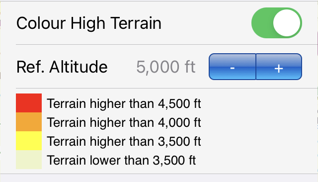
In SkyDemon it’s useful coulor with 500ft increments bellow the Reference Altitude that you enter
Unlike Garmin Terrain feature where it’s based on actual aircraft (GPS) altitude, red = terrain is +100ft higher, yellow = terrain between +100ft and -1000ft bellow and black = you are 1000ft above the ground
If you see red over the nose in Garmin you are pretty much fried !
Thanks!
The red color in easyvfr and skydemon means
terrain is
at least 500ft below
or
less than 500ft below or above
the aircraft?
There are drones now (fixed wing) flying long distances in rough terrain below 400 ft AGL. They fly pre-planned routes, and I guess the route planning is not a trivial task.
Peter wrote:
But really one also needs to consider the turn radius of a particular aircraft
Surely adding +/-2nm corridor margin will cover 30deg turn radius up to 200kts and work with the typical GNSS accuracy
If you add +/-5nm margin and Rate1 turn it’s off-airways visual IFR flying at 500ft agl, if you assume terrain = obstacle
The hard bit is getting route in HSI CDI, then the best deal is to leave that to AP in NAV mode while keeping eyes out, what is not a good idea is: using Lat/Lon coordinates, actively looking at tablet screen while zoom +/- and hand flying low between mountains…
Even without hitting anything, one will get sick or get vertige
I think this is a very nontrivial mathematical challenge. The algorithms, or at least the basic approach, are probably known, from the gaming/sim world, because they have to actually render the terrain from the POV of the aircraft.
But really one also needs to consider the turn radius of a particular aircraft – what one has to be mindful of when canyon flying in reality.