
It is a mystery to me why people attach so much importance to being able to display a scanned vfr chart when the information may be totally outdated within a month. That is why I am a big fan of Jepp MFDVFR – the charts are always up to date. Otherwise the standard Garmin Pilot – SD – EasyVFR charting is all I need or want.
I’ve used all of them (apart from Foreflight) and my iPad currently has Garmin Pilot, Jepp FD, SkyDemon, RocketRoute and Runway HD installed. My standard ‘mission profile’ is either a medium level IFR airways transit or a low level (3000-7000ft) outside of CAS transit to an IFR airfield. I operate through Europe, North Africa and the Middle East.
Over the last two years or so I have moved away from SkyDemon to Garmin Pilot as Garmin have enhanced their product. To me, the only part where SD still wins is with graphical NOTAMs and if Garmin crack this particular nut (they already manage with TFRs) then I will unsubscribe from SD. I would also like to see GP deliver IFR flight plan generation and submission options; hello Autorouter, there’s an opportunity here! GP has far greater depth, the aircraft management tools (Perf, W&B etc) are extremely comprehensive and overall the package is far more stable.
I occasionally fly helicopters (VFR) and prefer the detail offered by Runway HD using scanned CAA/OS charts over the ‘synthetic’ detail offered by SD.
In summary, SD was (and still is) a good product that changed the face of planning and navigation software. However, it’s lead is being/has been overcome by other products. The Garmin/Jepp product is very good, being regularly upgraded and, ultimately, has far stronger business foundation/support than SD can ever offer. SD is brilliant for the UK GA pilot and, to varying degrees, within other European countries; it is not a global product. That said, the GP package I use is close to EURO 1200 per year (!) although much of that cost is for the JEPP IFR coverage.
It is a mystery to me why people attach so much importance to being able to display a scanned vfr chart when the information may be totally outdated within a month. That is why I am a big fan of Jepp MFDVFR – the charts are always up to date
I agree with you, but
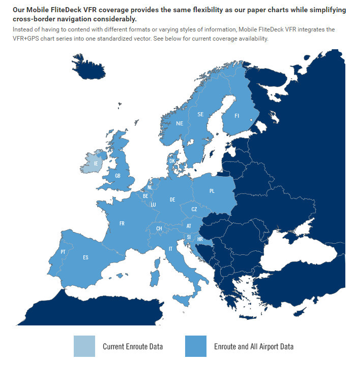
I had a 6 month trial of it in the early days and the poor coverage alone ruled it out, but then I need map coverage for everywhere I fly IFR, for Z/Y and emergency reasons (which need good topo maps which of the synthetic-map products only MFDVFR has) and while MFDVFR does now cover most relevant places it is still not quite there even now
What “paper charts” are they referring to? They dropped those in 2013.
They refer of course to the old VFR/GPS charts. My point is that JMFDVFR is the only product with realtime electronic “paper” charts. All the others are outdated on purchase. If we discount that advantage I like Garmin Pilot having grown up (?) with their presentation. Actually if you are going to use any of the competitors with “real” VFR charts from DFS or any other supplier by the time you buy the charts you might just as well go for the Jepp product, particularly if you fly to any degree in Germany. I suspect we will see an improvement in coverage within the next 3 – 4 months.
I believe all programs comes with + and -
For UK use I find very useful the Memory-Map as well.
A nice feature that I enjoy, is the option to easy calibrate and use your own charts.
When doing aeros is much easier to reposition your self with something so familiar like the CAA VFR charts.
Works well with PC-Android-Apple.
Looked at that Garmin Pilot. It’s not even available for download in Norway through Google Play. I can find it, but I cannot install it. So not all that “international” after all. EasyVFR and SD works everywhere.
Took a look at that Memory Map. Something like that for the M-517 maps in Norway would be great.
MM is a good way to run the UK CAA vfr charts. But otherwise a total dead end product.
I run them under Oziexplorer, along with vfr charts for all of Europe, but the sources for those are “interesting” at times :)
LeSving wrote:
You don’t have to press “Go Flying”, it does this automatically when you start flying
So why does it even exist? Superfluous and poorly thought out.
LeSving wrote:
Download manager poorly implemented?
Difficult to explain without a detailed write-up and comparison screenshots but in brief, GP has a far more robust system for reporting download availability, download sizes and expiration dates, and for queuing and retrying downloads. It’s a small thing which can take a huge amount of effort to do really well, or you can bang something out with a few hours development time which is what that part of SD feels like to me.
I guess it’s a bit like when someone posts a photo on here of a circuit board and Peter immediately sees lots of small things like connector and component choice which brings in to question the overall design and implementation quality. SkyDemon gives me a similar impression in many places so I choose not to trust my flying to it. In contrast, GP feels like a mini GTN/G1000 on iPad, which it effectively is in many ways due to a reused code base.
But I accept that SD is ahead in VFR mapping and NOTAMs for Europe, for now.
It’s actually a shame that SD isn’t stronger or that ForeFlight aren’t in Europe as we could do with some Garmin competition.
Peter wrote:
But otherwise a total dead end product.
Not at all.
Add Import 3rd party maps feature.
Use maps published by a 3rd party or self scanned maps Show contents.
It is easy to do and personal I did use it with jeppesen charts-maps.
To unlock this option you need about 15 USD.
Then you do the job on a laptop or desktop pc running windows with Memory Map software and when finish you just sending the map to your mobile device.Job Done.
Thank for all the comments!
Seems to be a combination of Garmin and SkyDemon. VFR for Sweden isn’t a problem actually, I’m not flying much up north.
If I start from my home airport in Sweden I’m almost in Germany already :-)
Another solution would be to just go with SkyDemon and use the AIP charts för IFR downloaded in SD. Then I can have them on two iPads.
But I’m eager to give Garmin Pilot a try, because a liked what I’ve seen so far.
The question is how good the Jeppesen Chart are? And if your willing paying all that money for it? :-)
Anyone know the cost for Garmin and the different add-ons they have?
I have to take a year with all of the apps and charts and try :-)


