@quatrelle There is a PDF about interpreting IR images on the manufacturers website IIRC, you might want to take a look.
Emir wrote:
This is how I interpret it (doesn’t neccesary has to be correct)
Emir,
Many thanks for your reply, I will try this out to see if I can understand it a bit more.
Can I add what a great piece of kit the ADL120 is.
@Emir
I tried the “tops” layer both of the ADL and in Autorouter/Telegram" (“tops”) on my last longer flight to the Netherlands – and the result was disappointing. On the way up “tops” and the ADL showed no cloud tops above 6000 ft for the whole route, while in reality I was on top in FL120 and the clouds were never more than 500 below me for the whole route. And that was a solid and thick overcast.
I don’t trust that data one bit, because it is almost never correct.
The problem with tops data is that there isn’t AFAIK any website which corrects the IR image colour temperature for any realistic temperatures aloft profile (e.g. from GFS).
There used to be a Spanish site (run by OGIMET IIRC) which did this but (we had a thread on it here) it apparently corrected it using the ISA temp profile which is obviously miles off during the summer (ISA+15 will result in the tops being thousands of feet higher than indicated, as well as creating hazardous conditions e.g. -6C at FL170 like I got last week, which preclude a climb to any enroute flight in IMC which might be ice-safe). I have access to a private site (no idea of the source) which does the same, and I don’t find it useful for cloud tops.
I am not sure if I follow the above but for sure a coincidence between radar and high tops does indicate bad wx. A lack of radar, and high tops, tends to be just a wispy cloud maybe at FL250+.
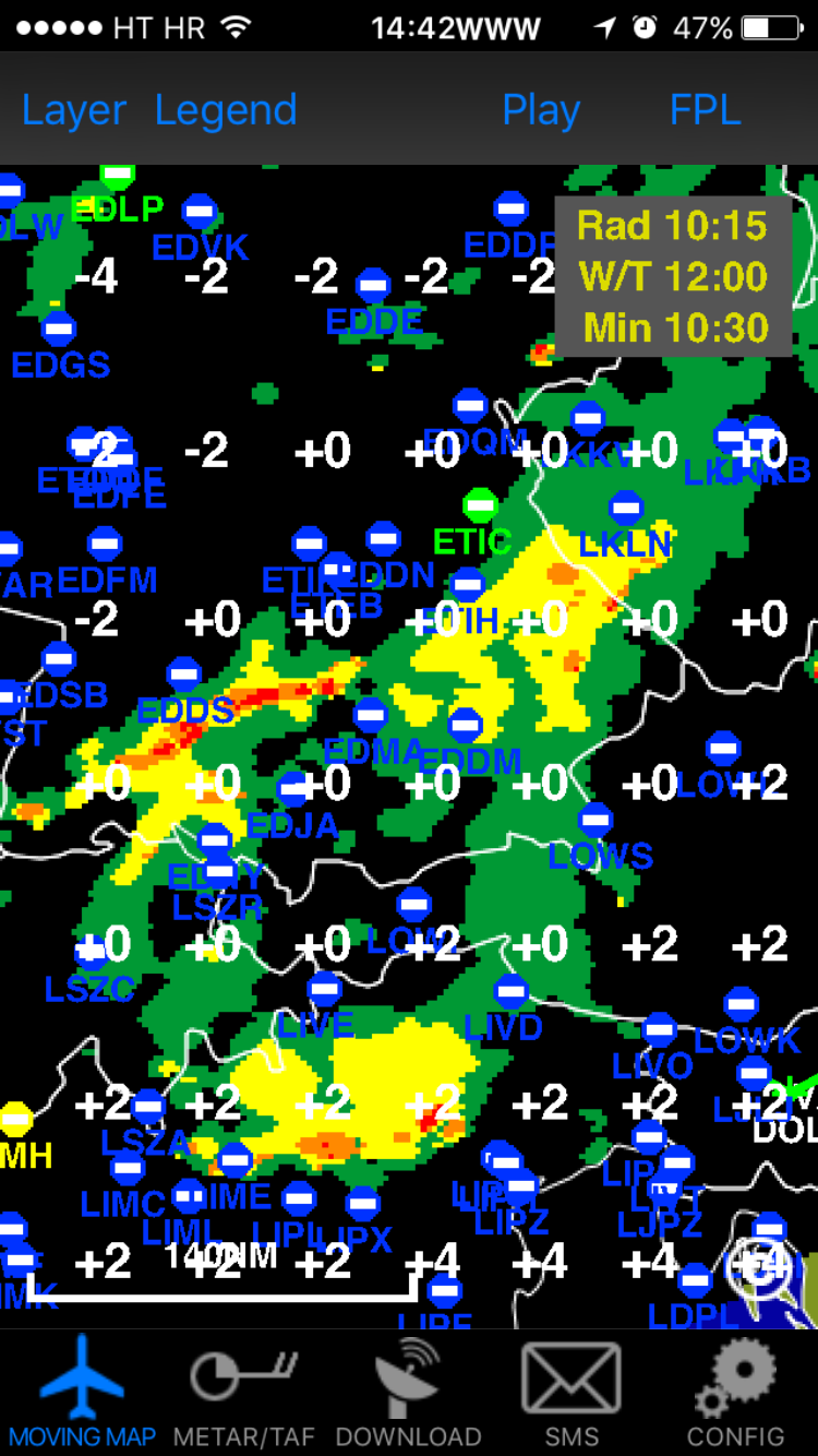
As an example
All layers on

Radar only
Infrared only
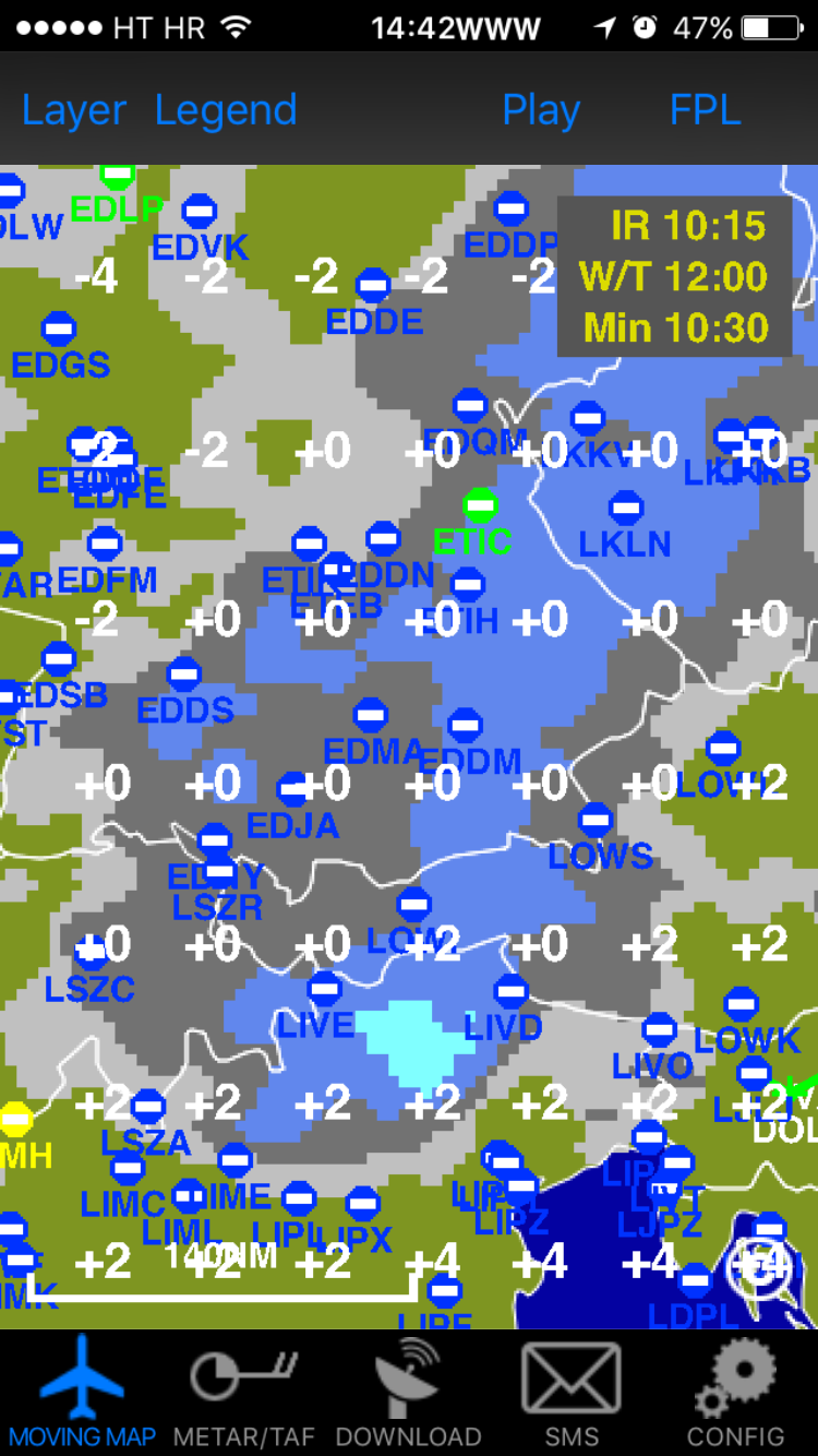
Radar and infrared

This is how I interpret it (doesn’t neccesary has to be correct) having the ability to FL180 (or maybe little bit higher).
Let’s say you see green and yelow on radar layer. When you turn it off (while having infrared on) you see in the same area:
- option #1 light grey – tops are low and precipitation seen at radar picture is at lower level so this could be overflown
- option #3 dark grey – tops are at mid level and maybe this can be overflown (to be visually confirmed) or you can fly through green area (of course checking OAT for freezing) or avoided
- option #3 cyan – tops can’t be overflown and this is probably associated with TCU or CB (although I would expect to see some orange and red at radar picture in this case) so you should circumnavigate this
Of course, there are different combinations, you’ll include strike in your analysis, depending on season different conclusions can be drawn and you should perceive it related to previously acquired forecasts …
Emir wrote:
Turning off radar layer can give you insight if something be overflown. Turning of infrared gives you better view on where actually cell is/was. Combining both pictures and previous conclusions should help in deciding on route and altitude.
I have tried this what Emir has described and cannot see how the cloud tops can be determined.
Maybe I am doing something wrong, could someone explain please?
What do you “highflyers” think of this http://feeloxy.com/shop/feeloxy-large-can-with-tube-and-mask/ ?
On top of solid IMC/icing, mountainious terrain…. aside, I think this can get me from say FL200 to FL130 in VMC in a few minutes and unlike the emergency O2-cans it is not permanent flow but has a push button to regulate.
This could be an option to an expensive second O2D2 to get one out of trouble without too much pressure of time, don’t you agree?
I have two O2D2 regulators (required for 3 or 4 people anyway) and a spare 1st stage regulator… IME one would need FL250 for relatively short periods only, though it does depend on your appetite for flying in really crap wx. Mostly it would be for crossing fronts, especially warm fronts. It is rare to see solid IMC even at FL200 for hours.
I think the FL250 capability you get with a turbo aircraft is great, though there is usually a price to be paid in the turbo engine life.
Interesting report, Stephan!
I’ve flown in similar weather and indeed the ADL is a very handy tool for finding your way through areas with weather. I don’t have onboard radar so need to stay visual when there are CB’s around.
Then Swiss Radar told me to descend to FL130 “at 1500 fpm or greater”. So dialed it in and kicked the nose over.
I got a similar request from Padova Radar when entering Italy over the Alps. I said “Unable” and got some headings instead.
For passenger comfort I always try to plan the descent with a 400-500fpm rate all the way down.
There must be an optimum (power setting / descent rate / IAS) to convert altitude into forward speed. I’ll start a separate thread on that…