Using FD cues, or flying the map, position yourself for finals battling the slashing rain and wind gusts, whilst configuring the aircraft… loads of fun in a very short time
You rarely get that much action going on  funny that Bale has both ENV plate & VPT plate that may not add up, need to send it to the consistency department
I recall at LeTouquet VFR circuit on VAC is north and IFR circling on IAP is south, makes some fun when you try to pull the 360 MVL in absence of ATC/AFIS without making a compromise !

Quote maybe in sophisticated FMS?
Well, don’t know about the biz jet world, but those are usually not included in the database. I’ve used Jeppesen, Aerads, and LIDO on different airliners, and we always, if so desired, programmed them manually.
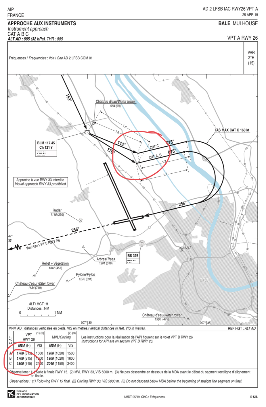
Below another good example, BLM circling for 26, as used in strong westerlies on wet runway (due to lower wind limitations on the Airbus for instance). These are not prescribed flight tracks, but recommended… The way it was done (small variations between crews are possible ), was to program the FMS with waypoints such as BLM/113/1.6 and name given to previous//255/1.7 for CAT C. This had them show on the ND, and the route properly drawn and sequenced (very important in case of GA, but I digress). So, the initial approach was either RNAV, or ILS, or VOR15, making visual contact with the airport latest at the MDA, switch to HDG or better TRK (yep, the birdie on the Bus) mode just prior BLM (or switch all automatics off, then ask the PNF for appropriate selection). Using FD cues, or flying the map, position yourself for finals battling the slashing rain and wind gusts, whilst configuring the aircraft… loads of fun in a very short time

The Jepp LFBD 19-11 visual does not have prescribed track just a no go zone to keep to one side (which is materialised by a DME/ADF), the Jepp LFBD 19-10 visual does have mandatory prescribed track to fly, you should overfly SOGBO at 5kft and stay along the GPS guidance within 0.3nm all the way on visual approach
The Go/NoGo zones under the IFR Visual are not consistent with the Go/NoGo zones in the VFR VAC, something to meditate, just like many places where VFR circuits is to the north and IFR circling is to the south, you don’t want to mix the two when doing circling/circuit mix


Peter wrote:
Which of the many charts here is this a reference to?
The LFBD ENV charts from AIP-France and the Jepp LFBD 19-11 and 19-12.
I always thought a prescribed track is a prescribed track, although in light GA one tends to fly well within it
Yes, but the lines on these charts are not prescribed tracks, so they are not prescribed tracks. :-) There is no mention at all on the charts of prescribed tracks, just that you need to avoid some areas which are delineated with certain lines.
It’s shame VPT (or some very policed visual circuits) can’t be loaded in GPS/HSI, maybe in sophisticated FMS?
Yes one should get as GeoRef plates in tablets with aircraft position (e.g. JeppFD) but you have to look at the tablet while near the ground rather than looking to your PFD (while doing that remember to look outside as the wing is likely to be kissing some mountains as in Annecy VPT)
For Cannes unfortunately, there is no loadable plate for the VPT
This is what Jepp have:

If this stuff is georeferenced and displayed on some kind of moving map, you could just follow the track on that. That’s how I fly VFR when required to route via some VRP; most VRPs are invisible except to locals.
For Cannes unfortunately, there is no loadable plate for the VPT with a mix of visual and gps although you mustn’t bust altitude or point, before the short final or the owner will receive an email or a call, if you have an ADSB transponder.
The main problem is that it mixes some visual references with gps (LUXUS and PIBON which are visually identified), and pure gps point (point À and B for the base turn) with altitude constraints. You have to start your base turn over a big round about on a highway but not cross them…
This is the worst VPT I have seen, and it’s often busted. I have sent them possible improvements, but they actually don’t really care
That’s about it,.but GPS makes things so much easier, I assume that as there is a plate, it will also be in the database on the MFD.
OK “prescribed boundary” makes more sense, how it’s flown you load something in FMS or navigator? you tune DME/ADF? or keep some building landmarks on your left?
It seems you will need to flyby SOGBO at 5kft for the visual 05 though?
A prescribed track VPT or as I wrote previously MVI (manoeuvre visual impose) is a circle to land for which there is usually a plate and it lays out the tracks you should follow during the circle to land. There are no options if the VPT says turn right and fly outbound heading 230° for 2.2nm that’s what you do. It’s often marked up with different distances and sometimes tracks for the different categories of aircraft. You do not fly inside that or outside, it is a prescribed track as opposed the MVL which you.can do the circle to land your own way.
It is a visual manoeuvre just as the circle to land is but the GPS can be useful otherwise you are making mental calculations or looking for certain visual points.