
What next
I can find a new waypoint much quicker on paper, sometimes
Quicker than tapping the search icon and entering the name on a mobile device?
The only paper I use these days is the one to clean the oil dipstick. Haven’t found a suitable app for that yet…
For new waypoints, I always use my “tactical” GPS which is a Garmin 695 on my yoke. I punch in what ATC told me, check how it affects the route, decide whether I want to protest and then enter it into the GNS430W which has the sole purpose of feeding my autopilot. If you have a whole string of waypoints, you never know where the new ATC waypoint fits in so I think it is very practical to a “tactical” GPS to first get an understanding. You can also use a tablet for that but I still like my military grade 695 brick 
I can find a new waypoint much quicker on paper, sometimes
This is what makes electronic “airway” (IFR) charts tricky. They all use auto declutter and you can get a scenario where intersections on your route are shown but nearby ones aren’t – or some nearby ones aren’t.
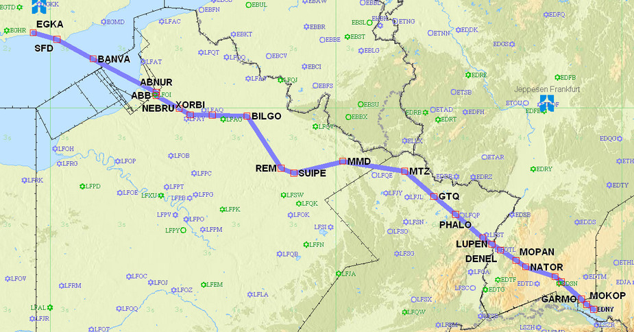
When I print off strip charts from Flitestar, I use 10nm=1" to get everything to show. For a flight of say 700nm you get about 5-7 A4 pages.
If the MEA is ok, then the terrain clearance will too, i guess, and that’s what i want to make sure.
Still, MEAs are often several thousand feet higher than the MSA. In places like Sweden, Norway, Poland, Italy, Spain etc., it is often 5000 to 8000 feet more. For real MSAs, I would indeed refer to the GPS or your VFR chart.
Quicker than tapping the search icon and entering the name on a mobile device?
Yes, most times quicker. I really don’t have to be convinced about using eletronic devices. I use them for practically all purposes. But in some situations a paper chart is fine. Looks like this is becoming a taboo.
I also have to check if the JeppView enroute charts on my iPad have a search feature ;-)
Also, the four-device Jepp subscription can be shared, ahem, four ways, but only one set of paper enroute charts comes with it, which means that approximately 74.99% of Jepp terminal chart users don’t get the paper enroute chart
Jeppview can search for a waypoint, etc, but it zooms you in by some huge factor and then you have to zoom out and re-orientate yourself.
I see, have to try that. Thank you.
Also, the four-device Jepp subscription can be shared, ahem, four ways, but only one set of paper enroute charts comes with it…
We have our JeppView subscription completely without the paper charts. Saves a four-digit figure over the year for the fleet.
And when sent directly to a waypoint, I don’t bother to look that up anywhere. Just type/dial it in and if the bearing and distance look reasonable, press “Enter”. Otherwise have it spelt by ATC and repeat the procedure.
The only paper I use these days is the one to clean the oil dipstick.
I must admit that I still print plates for starting point and destination, although I never use it since I have plates on iPad and iPhone.
And when sent directly to a waypoint, I don’t bother to look that up anywhere. Just type/dial it in and if the bearing and distance look reasonable, press “Enter”. Otherwise have it spelt by ATC and repeat the procedure.
I agree; I stopped printing out enroute strip charts (as an experiment) about a year ago. I just print off the whole route on one page, which shows most of the waypoints e.g.


