I think there’s more to it than simple mapping problems and/or failure to climb to the pass-crossing altitude in good time.
This guy read and posted on EuroGA, so was clearly absorbing information and learning. He had bought his own Arrow and while this may have been his first mountain flight it wasn’t his first venture into Europe. I think it’s unlikely he was flying with the <2,000ft UK PPL mentality.
Planning something like this the minimum safe altitude for the crossing would be etched on your heart and one wouldn’t fly lower for a while just because it looked ok.
I feel it is more likely that something unexpected happened.
Peter wrote:
Something else must have happened. I would bet on it involving a bit of IMC. Look at the webcam pic which shows some cloud around the peaks. There was AFAICT almost no wind (see the webcam pic, and the crash site pic) so little potential for downdraughts and such. And nobody who is awake is going to fly into terrain when they can see it. They might in a box canyon (it’s been done many times) but this one was plenty wide enough.
If you are not high enough you pull on the handle to take the attitude, so you lose speed and you finally stoll ! Several accidents have occurred in Switzerland in this way despite the very good weather and pilots for very experienced
Peter wrote:
There was AFAICT almost no wind (see the webcam pic, and the crash site pic) so little potential for downdraughts and such.
I think unfortunately this is very incorrect. Downdrafts are rarely caused by the apparent wind at altitude in the Alps. They are very often a very local phenomenon caused by the heating of the mountain on 1 side and the air being compressed and a accelerated downwards on the other side. I think this is something pilots not used to living or flying in the Alps forget, and they only think about the mountain wave effect (which is indeed caused by the relevant winds (usually from the N or the S). The real downdrafts (which hangliders etc know much more about) are not caused by altitude winds at all. btw not suggesting in any way this is what caused the tragedy to happen here.
Peter wrote:
Is that map in feet or metres (elevations)?The one time in my 18 years of flying that I think I could have got killed was flying with Swiss charts which had elevations in metres. Luckily I got any IMC out of the way over France, using the Jepp charts. Then changing to the Swiss charts, which mix feet and metres on the same bit of paper, I was in VMC but wondering why the cows look so big. Switzerland was not in the EU so with no farming subsidies the cows should have been normal size. I am certain many have died due to this (I am far from the only pilot who thinks that) but nobody would admit it even if the evidence survived the crash.
The ICAO Swiss charts are of all kinds! Thank you for not inventing anything.
If you had a map in meters it was definitely a glider map (which they use the meters in Europe)
That’s what SD would show you approaching the Simplon at 6000ft :
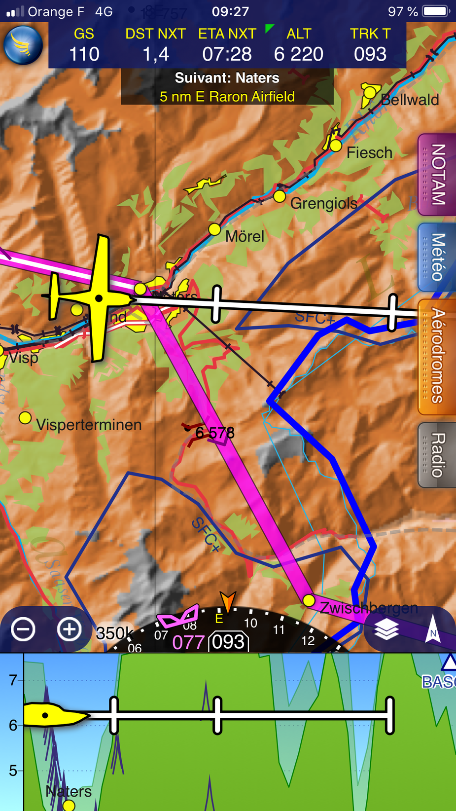
The profile view is pretty clear and the altitude of the pass is there in feet. And I hid all the cableway and antenna alarms popping.
Maybe he wanted to minimize their time above 6000ft for the baby’s ears, and expected to outclimb the pass in the valley. Risky.
Is it possible to configure SD to suppress some of that info?
Has anyone listened to the ATC sound track, posted earlier? I have listed to a bit and will do more later. The pilot is heard 9nm west of Sion 5200ft on QNH1021. Then there is call asking for the next frequency and he is given 126.35, and obviously he won’t appear on this recording any more. Can anyone locate the ATC track for 126.35?
Or, if you turn on terrain in SD, it will look like this. Pretty hard to ignore.
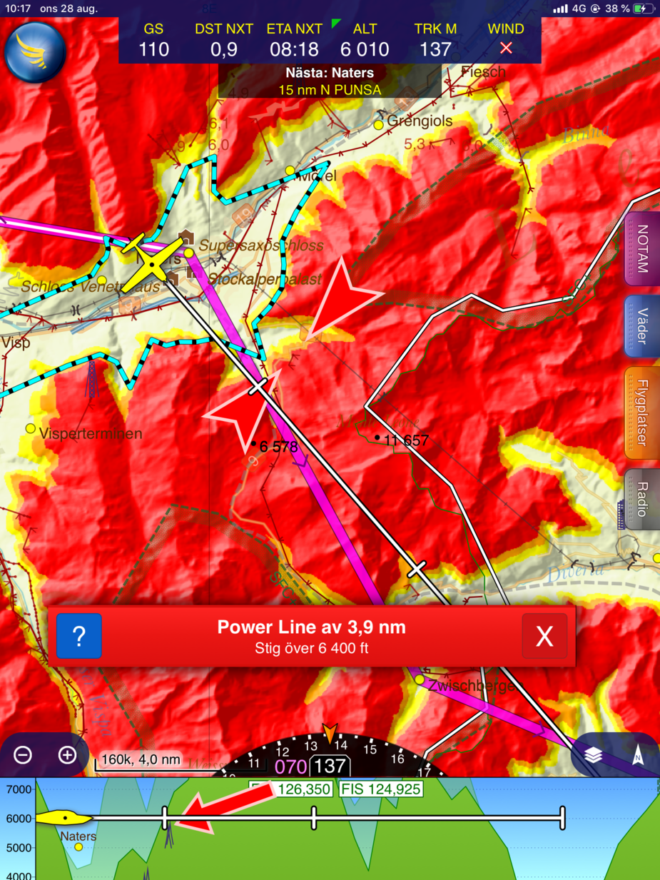
Flying at 6000 ft in the Alps is simply nonsense
It sure is (in most places there, not all) but ask yourself what information sources were reasonably accessible to this pilot.
I disagree very strongly, while defending the right of people who don’t hold an EASA mountain rating to express their opinions on the subject of alpine flying.
What is “nonsense” is to fly in terrain by reference to any baro altitude. We sometimes determine and set approximate local QNH at our destination by reference to ground features, but our primary en-route reference is those ground features.
It is also nonsense to speculate as to the causes of an accident when, as a spokesman for police in the Swiss canton of Valais told The Telegraph: “It’s far too early to say what may have caused the crash.”
I have listened to the ATC at Sion and it gives almost no information.
Some very woolly thoughts:
But these are huge jumps from very little information.
Peter wrote:
Can anyone locate the ATC track for 126.35?
126.35 is the flight information from Geneva.
I can not confirm that at 6000 feet Brig, we can receive it. In any case, in Sion at 6’000 ft impossible to get in touch with GVA info 126.35