I agree, seeing some of the smiling happy family pictures is heartbreaking. Whether I am over cautious or other people are more confident than me, I don’t know, but when I fly my young family it is on a local ‘burger run’ in good weather just for the fun of being airborne. The only way I’ll go near terrain or over water with family is down the back of an orange airbus drinking a coffee. I just can’t reconcile the hassle/stress/risk of using a light single for family travel [not in any way knocking those that do – it’s my personal take]
Peter wrote:
Is that map in feet or metres (elevations)?
That map is in meters, because it isn’t the aviation chart. I used it because it does a better job at showing terrain (altitude lines etc.).
That makes the crash site about 7000ft; not a lot.
Was the baby new born or just very young? If less than 6 months, it could explain he seeks for lower altitude. At this age, there is not only the eustache Tube being to thin to adapt the pressure; some french studies I have read did mention that it could be dangerous.
https://www.secours-montagne.fr/IMG/pdf/ALTI-age-rhem.pdf
I frequently bring children in around 11500ft to cure the whooping cough, but they are over 3yo.
it could explain this search for the lowest altitude.
Peter wrote:
t sure is (in most places there, not all) but ask yourself what information sources were reasonably accessible to this pilot.
A chart? Or even a road map (like the one referenced above)?
greg_mp wrote:
could explain this search for the lowest altitude.
Fair enough, but then why attempt to cross the Alps at all? You can fly across the lower parts in Austria or around them altogether via France.
Something just doesn’t add up here. I mean, seriously: you try to fly across some of the higher terrain in Europe and don’t plan your route including altitudes you need? I find this very, very hard to believe.
This one is a mystery to me. The weather here was severe clear around Lake Geneva (I live in the area) with a few puffs around some peaks in mountainous area south of Sion indicated by webcam shot by gigicr. But these puffs were very small as one can see from other webcams in the mountainous areas. They should have been absolutely no problem whatsoever to avoid. Even for a normally aspirated Arrow. Yes, DA’s were high that day, and it was hot (close to 30 C) but primarily in the afternoon. It was a perfect day for crossing the alps in the morning (returns can be tricky summertime due to CU/CB/TS build-ups).
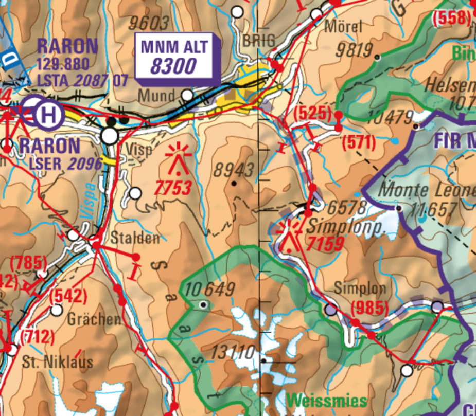
What strikes me is the vertical profile being stable at 6000ft for so long in the FR24 capture. Only very late a small increase in altitude. It only leads me to believe he as seen the approx 2000m somewhere (as indicated in one of the GPS shots earlier in the thread) the altitude of the pass and translated that to 6000ft and was sticking to that initially. The Swiss ICAO map below clearly indicates the alt of the Simplon pass is 6578ft. And recommends a MNM ALT on that route of 8300. Which is very good margin for the pass itself, but less so for the highlighted mast at 7159 ft almost on the route… Then it’s only about a 1000ft margin with the usual instrument / QNH / rounding error margins of about 150ft. From the ICAO map below (even if maybe confusing if never have seen it before) it is crystal clear that 6000ft will not be enough. There’s massive time to climb from Lausanne to required altitudes even in an arrow with 2.5 adults aboard a summer morning, but again FR24 clearly shows a stop at 6000ft.
So, remaining at 6000ft and then as closing in on the pass realising visually a climb is necessary, climb is initiated, maybe too late for a good margin to the pass (maybe due a puff of cloud or to the child as discussed earlier) but my guess would be he hit one of cables that are indicated on the map below by being too low in the first place. I just don’t see how one could go IMC into one of few (small) puffs that could be on the way to the pass with family on board knowing that already 6000ft would be ‘close’ to the (wrongly) understood level of the pass (6000ft) especially as there must have been plenty of room given the very few clouds to circle back to gain altitude if necessary. Guess we’ll have to wait and see further what the investigation says.
What else could there be? Mechanical problems? As an owner of his plane and an experienced long distance traveller I’m sure he was aware how to operate it (lean etc) to fly above 6000ft…
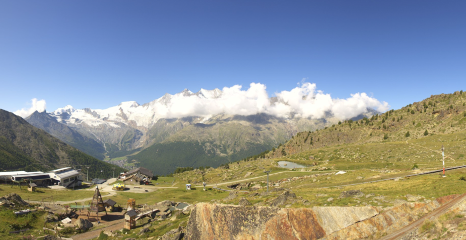
Here’s a screen shot below from a webcam (at 2400m) in Saas Fee ski area at 1040 local the same morning. It is located roughly at lower left corner of map above. Just to give you an idea of the size of the potential few clouds on the way. They were small and avoidable (higher even if orbits needed, or to the sides). Really. And I really only screenshot pasted in the 90 degrees of the round shot that have any clouds… the remaining 270 degrees of the full round shot have zero clouds.
Sad sad story on such a beautiful day.
Grassfield wrote:
What strikes me is the vertical profile being stable at 6000ft for so long in the FR24 capture.
The FR24 track suggests the lateral and vertical paths of the flight were on AP? I am not sure how wise to set GPS waypoints or altitude/climb profiles to fly on AP in the valleys?
One would either get hand on and fly it at 6500ft just inches from terrain with plenty of space/speed room to turn away from the ridges? or just fly it in middle or wherever you like at 8500ft above all of it on AP?
What a tragedy! :-( What about the winds on that particular daytime? The Simplon is quite famous for Föhn winds, but looking at the pictures, it seems not very windy?
Peter wrote:
I have always flown straight over the top, FL140+, even when VFR (and got a load of grief from Swiss ATC) but he could not have done that.Swiss ATC seems to guard their class C, as if it was class A. I’ve written a longer text about it, but I think its more appropriate to discuss that in an another topic.
I checked historical flights for G-BVDH and for the last 12 months there were no mountain flights.
It would be interesting to know if the pilot had any mountain flying experience. And if so, what was his modus operandi..
Since he was not a Swiss pilot, he was 90% chance not using the Swiss ICAO Chart.
Foreign Pilot mostly use either Skydemon (rarely with national ICAO chart overlays) or JMFDVFR.
Since he was a UK pilot, there is a 90% chance he used Skydemon.
As we all know, Skydemon (on their prorietary mapping) does not show terrain altitudes in the mountains very well.