
That’s very interesting – thanks. How much of this is autopilot-coupled? The +V portion obviously can be.
Which altitudes does the VNAV fly?
Peter wrote:
I suppose the basic Q is whether +V works only for laterally straight trajectories i.e. past the FAF, where (in GA context) you don’t have a curved path.
In non-SBAS box, APR is annunciated 2nm before FAF on intermediate segment (IF/FAF) then in the whole final segment (FAF/MAPt), before that you are on TERM/ENR
In SBAS box, LNAV+V is annunciated somewhere in the intermediate segment (IF/FAF), somewhere depending on linear CDI scaling from TERM at IF to LNAV+V at FAF, before that you are likely to be on TERM/ENR & VNAV, now you are asking the question on curved segments, I have no clue BUT you should always see LNAV+V at FAF-2nm, it’s obligatoire…
What I was saying before had to do with being able to see +V in the first place, if it penetrates obstacles surface Garmin will not show it, LGIO case is an edge one as +V GP does penetrate the OSC surface dead on the edge of the corner at FAF & 3200ft, something one should know about !
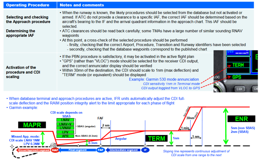
in LGIO the +V GP does penetrate the FAF & 3200ft dead on the edge of the corner of the OSC surface
The +V is not supposed to penetrate anything before the DH.

Peter wrote:
The +V is not supposed to penetrate anything before the DH
3200ft = Platform Altitude = SMA between IF/FAF, I am sure +V penetrates there 
Do you know other plates where platform altitude exactly matches the min segment altitude?
I know RNP17 at Cannes does it but no LNAV+V sadly, flown straight & level
You can’t afford to be -0.5dot bellow +V near FAF at LGIO 
Peter wrote:
That’s very interesting – thanks. How much of this is autopilot-coupled? The +V portion obviously can be.
According to the GTM650Xi AFMS you need a Garmin autopilot to couple VNAV.
Which altitudes does the VNAV fly?
It flies the altitudes given on the approach chart.
Airborne_Again wrote:
According to the GTM650Xi AFMS you need a Garmin autopilot to couple VNAV.
Are you talking about the Approach VNAV or Enroute VNAV? I think Garmin-only A/P was for the latter.
It flies the altitudes given on the approach chart
These ones?
Initially fly to YNN, at/above the sector MSA as usual.
Enroute to IO711, descend 9000ft.
Enroute to IO712, descend 8500ft.
Enroute to AMIVI, descend 7600ft.
Enroute to IO713, descend 6300ft.
Enroute to IO714, descend 5200ft.
Enroute to IO716, descend 4200ft.
Enroute to IO717, descend 3200ft.
and down you go as per the VS/GS chart, to the MDA.
You can’t afford to be -0.5dot bellow +V near FAF at LGIO
Is that actually true, relative to real terrain? This video ends with a landing at LGIO in VMC all the way
I don’t have the time right now to work out the trig of whether the 3200ft SDF (IO717) conflicts with 4200ft at IO716, and with the DH point at the other end. AIUI that conflict should not happen on a published +V glideslope, and Jepp are entitled to lift either end (IO717, and/or the DH) on a published +V.
arj1 wrote:
Are you talking about the Approach VNAV or Enroute VNAV? I think Garmin-only A/P was for the latter.
What’s “approach VNAV”? Do you mean +V? That would work with any A/P that can be interfaced to the GTN650Xi.
Peter wrote:
These ones?Initially fly to YNN, at/above the sector MSA as usual.
Enroute to IO711, descend 9000ft.
Enroute to IO712, descend 8500ft.
Enroute to AMIVI, descend 7600ft.
Enroute to IO713, descend 6300ft.
Enroute to IO714, descend 5200ft.
Enroute to IO716, descend 4200ft.
Enroute to IO717, descend 3200ft.
Yes.
Airborne_Again wrote:
arj1 wrote: Are you talking about the Approach VNAV or Enroute VNAV? I think Garmin-only A/P was for the latter.What’s “approach VNAV”? Do you mean +V? That would work with any A/P that can be interfaced to the GTN650Xi.
@Airborne_Again, on Garmin you can drive a GPS “glideslope” (VNAV for LPV or +V) from a GTN and many autopilots support it.
But GTN could also do “enroute VNAV” where you put the VNAV constraints for the normal route and it should bring you down as needed.
So my question was just to clarify which case you meant in your statement.


