JasonC wrote:
Ah Europe. Never found a simple thing it couldn’t turn into a two day process.
I couldn’t agree more.
quatrelle wrote:
JasonC wrote: Ah Europe. Never found a simple thing it couldn’t turn into a two day process.I couldn’t agree more.
:Really laughing a good one at that fellas!:
So I’m confused, I have live B737 & A320 ratings and have had the training to do the full gambit of GPS based approaches on these aircraft and now I need another qualification to drive my PA28 down an LPV gps approach using a GTN650 ?…………
A_and_C wrote:
So I’m confused, I have live B737 & A320 ratings and have had the training to do the full gambit of GPS based approaches on these aircraft and now I need another qualification to drive my PA28 down an LPV gps approach using a GTN650 ?…………
Don’t be ridiculous. Your fancy, schmantzy qualifications don’t enable you to fly an aircraft with the complexity of a PA28 + GTN650 on a GPS approach. I am surprised you can even get airborne without a copilot calling stuff out…..
Best you go to your local ATO where they can explain how to follow a localiser and glidepath down to a minima, fill in several forms and then, if you do well, sign you off. It is irrelevant that the person so doing has probably flown a fraction of the number of such approaches that you have already done. You were probably not doing them correctly. Until then you are a risk to yourself and more importantly others.
For the avoidance of doubt 
I do not want to be an apologist for the requirements, but there is developing a self righteous group think here that might be missing the wider picture.
There are two elements, flying an approach and TK.
It seems perfectly sensible that, if the majority of approaches are going to be RNP (RNAV, GNSS, GPS, whatever you wish to call them), then they should be demonstrated on a Skills Test and reval, just as it used to be a precision and non precision approach.
On the TK, it’s all very well to say “it’s easy to fly an RNP approach”, but that is when all goes to plan. So much TK (in all subjects) is about the weaknesses and limitations of systems. (My life was once saved by my digging out my long ignored knowledge of how the ILS actually works at a wiggly amps level).
So here, as a thought experiment, are a number of questions for people to answer in their own heads.
Please the rest of us don’t blurt out the answers. I know some of us know the answers, but my experience as both an instructor and of giving lectures on PBN to hundreds, maybe thousands, of pilots is that most people don’t know most of this thoroughly practical set of questions. The point is for people to actually muse for themselves whether they really know enough already.
I could go on, but I hope you can see that all those questions are purely practical and useful, yet I would guess that more than half the IFR pilots reading this will be unable to answer more than half the questions.
Please, for the moment, don’t show off by giving the answers.
Give people the chance to introspect as to whether they know them and whether there is actually some benefit in some kind of test. (I agree with the UK CAA that the test should be oral; actually, it may have been me who suggested it to them.)
I have just heard from the examiner who has been doing my EASA IR revalidation that he has had his PBN signoff qualification approved by the CAA but is waiting for his license to be re-issued so he can do it. So it is happening…
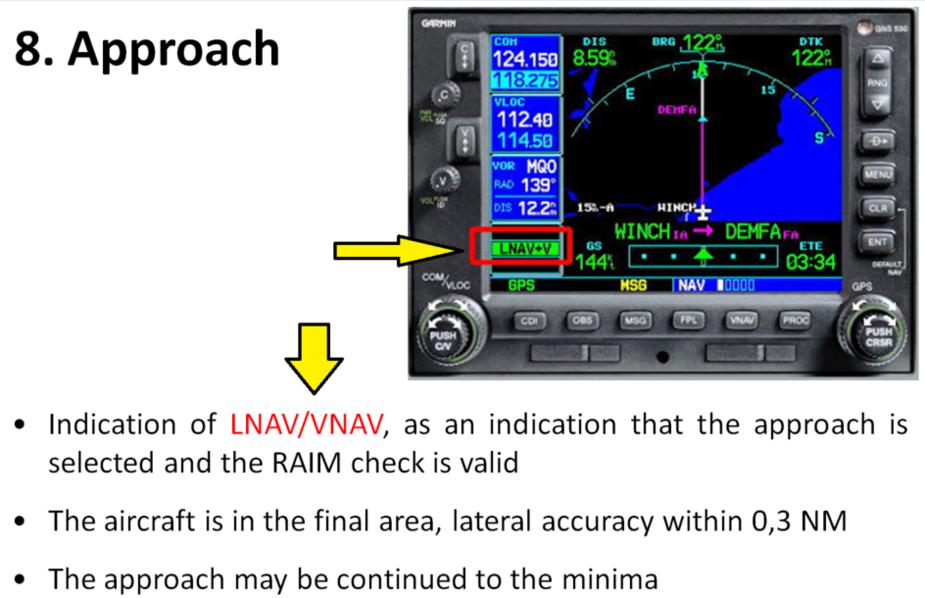
Yet, the atomic clock bureaucrats manage to produce this confusing slide…
Do they intent to talk about LNAV, about LNAV+V or about LNAV/VNAV?
achimha wrote:
Hmm… just yesterday I once again forgot to set the CRS pointer for an ILS on time and was wondering where my localizer was. Can’t happen with an RNAV approach.
I’m glad it’s not just me. On Friday I made an ILS approach where I had set the course on the EHSI, but then had to continue using GPS guidance to a waypoint. When the vector to intercept came, I flipped back to NAV but assumed the course would remain as previously selected. It wasn’t of course, it was the previous GPS course, which was more than 90 degrees off. It took a while to work out why the indication was showing “BC” and moving the wrong way.
I don’t know the answers to most of Timothy’s list though I reckon the answers to 15 and 16 are going to be, ahem, somewhat personal choices, with a significant “UK and G-reg” bias  They also vary massively by whether you are the only pilot of the plane and the only one messing with the GPS.
I can see that half of it is really a “WAAS GPS Class 101” thing which comes back to knowing the aircraft systems in huge detail. For example I have flown loads of GPS approaches but have never “activated” an approach. This stuff is massively box-specific. And you will struggle finding instructors who know anything about it. When I got my plane in 2002 I never found an FI who knew the KLN94 and I doubt I would find one today!
As regards mixing up ILS and GPS guidance… when I am heading for an ILS I fly in HDG mode until LOC intercept. What else should one do? Always use the simplest mode which does the job. And you have to know your EHSI e.g. the course pointer has to be set, not least because if the CP points more than 90 degrees off the LOC inbound you get a BC indication and the glideslope will be suppressed (because there is never a GS on a back course) whereas with the old CDI it doesn’t matter what the OBS is set to (well, you might fail your checkride ).