Airborne_Again wrote:
You know, if you from the outset had said that a reasonable interpretation of the lower limit of a CTA being expressed as a flight level is that it can never be lower than the transition altitude, then this discussion would have been very different. Instead you went off arguing about altimeter setting procedures which no one here have disagreed with.
Indeed. I can understand having different opinions and discussing about a reasonable interpretation of what “busting” airspace means, theoretically and in practice, as this is not trivial stuff.
But what really gets me is the guy giving his lecture from a sort of moral high ground with things like:
hazek wrote:
and deserve your license to be suspended, you are also being grossly negligent, irresponsible and dangerous.
hazek wrote:
it’s a matter of life and death.
hazek wrote:
you could literally die if you don’t understand
hazek wrote:
I mean c’mon. Do better. You owe it yourselves.
While he has repeatedly shown that he lacks basic understanding of fundamental altimetry concepts.
Graham wrote:
For the record, I have no idea how to establish TL/TA at any given point in the ludicrously complex UK environment. My work around is that I use altitudes unless (a) FLs become relevant due to proximity of CAS with the base defined as an FL, or (b) an ATCO to whom I’m reporting my level makes it clear they want to talk in FLs.
I do the same:
- close to CAS ceiling – in the same units; or
- check ATIS on departure (if depart into the “airways system”); or
- “ask someone” (meaning ATS) :).
Yes Peter, France does have a lot of CAS and Resticted Airspace.
However, the original question is really more academic Tthan practical here.
OCAS above 3000’ AMSL and outside of mountainous areas we would automatically switch to 1013 on the altimeter. So the situation of flying at 4500ft QNH 964 doesn’t actually enter the equation as we are already flying at flight levels. Base of CAS FL055 not a problem :we are flying at FL045 no calculations needed.
But unlike Graham we do use a lot of mental arithmatic during training for PPL and even more for the IR. I bought 2 whizzy wheels 1 for PPL and later 1 for the IR for my training plus a flight calculator/computer and I can count on my fingers how many times I actually used them, other than to see how to.
Inside CAS TA/TL is usually a moveable feast and is set IIUC with the actual recorded pressure (QFF/QNH?) as a reference.
Flight levels/altitudes/heights are all taught mainly to avoid running into each other by us all working to the same reference.
But they are only one part of the obstacle avoidance strategy. For that you need True Altitude especially when you are flying from a high pressure area to low pressure and low temperatures area.
The altitude of Mont Blanc or any other major obstacle is a measured or true altitude which does not change. So to make sure you don’t hit it you must be aware of what your true altitude is and that needs knowledge of your QNH plus the temperature and how to calculate it. Another good reason to have 2 altimeters 1 at pressure altitude and the other on standard. But that is off topic.
The height/altitude of Mont Blanc like any other obstacle might change which is why ordnance survey teams do regular checks.
( this is for the anoraks on here)
Be careful with GPS altitude. It is a virtual altitude(point.in space), calculated by trigonometry and superimposed on a chart which based on a WGS 84 (format with its own rules/ calculations)
Ordinance survey is physically measured and the charts made up from those measurements. They can give very different results. You might want to try a little experiment. Find an obstacle that can be seen both on your GPS and on an ordnance survey map and look at the Lat and Long of that point. Sometimes you would be surprised at how far apart they are. The same applies if you were to climb to the top of that obstacle and do the same again.
It is for the coherence of the virtual world to the real/physical world that WAAS and EGNOS are really all about.
Try it for yourself. I did it at the Greenwich Meridian, for a programme I was making, and was quite shocked at the result.
Yes, but if I am going to publish a video of flying above the summit, +500ft being the law in CH and probably FR too, and the video has the GPS altitude in the subtitles… 
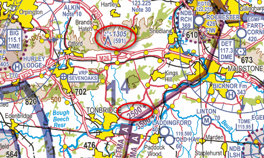
In reality, in this context (enforcement), terrain clearance doesn’t normally come into it. The one aspect where it does is when e.g. flying below the 2500ft UK LTMA base, two things are fairly obvious when you look at the map:
The other thing aside to altimetry, in the context of this thread which is mostly about VFR busts in VMC you stay safe not by looking at the altimeter, but by looking out the window. The technical discussion on alitmetry is all about where airspace boundaries will be defined (and enforced in the UK by CAIT) which cannot be seen with the naked eye, not about running into transmission towers or hillsides which are clearly visible by looking out of the window.
I wasn’t referring to legality more to safety in the case of true altitude.
I’m not sure what you are referring to in flying semicircular levels is mainly impossible.
In the areas you circle it seems that MORA is 1400ft set to QNH but you need to pass that obstacle 150m(?) left or right.
I don’t see anything there which enforces a FL. Unlike other countries it seems that the advice in the UK would be to fly in this area somewhere between 1400ft and 2300ft on a QNH given by, I can only guess,at London Information or London Control. There would be no necessity to fly semicircular rules at these altitudes.
150m?
Yes I did put ? because offhand I couldn’t remember the exact phrase.
Translation from FFA memo VFR
“500ft minimum, beyond the summit of all isolated obstacles in a radius of 150m around the aircraft”
I do not know whether the UK operate this rule.