The preliminary report is out for Getjet Malta A320 at Paris on May 23rd 2022, which descended below safe height on approach twice.
The swiss cheese really lined up that day. Something to bear in mind for those with Instrument Ratings and flying an RNP/LVP as they are based on the QNH you put in the dial. Hate to think if this was a SEP without Radio Altimeter. 6ft from hitting the deck!!!!
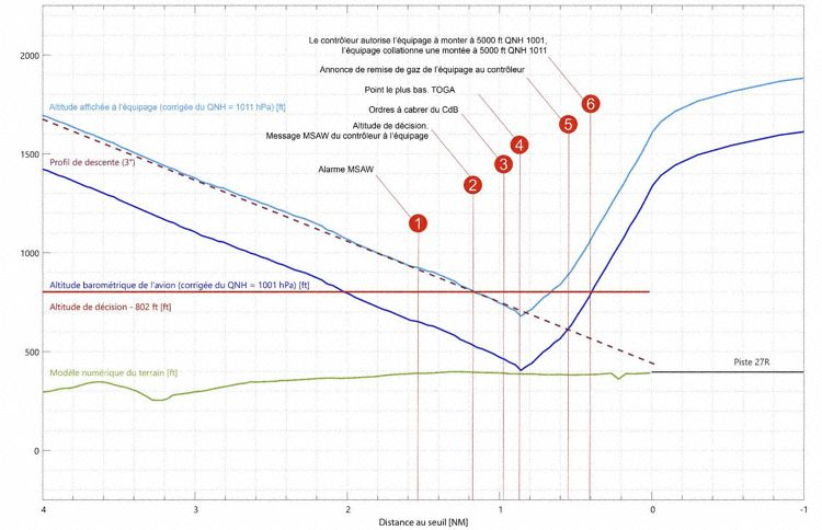
Flight Trajectory of first approach (Graphics: BEA):
Hate to think if this was a SEP without Radio Altimeter
Sorry, but you will not hit terrain on RNP LNAV & VNAV no matter what QNH you put in your altimeter as geometric glidepath comes from your GPS
RNP L/VNAV minima can be flown on BARO or SBAS, in the former you are subject to QNH error and temperature correction, in the latter, pressure and temperature are irrelevant
The minima to continue approach bellow descison height relies on your QNH input but usually in SEP while on glidepath you should see runway lined up in front of you bellow DH if you stay on SBAS L/VNAV glide path and you are protected (you may not see runway at all after crahsing on it if ceiling is 0ft & visbility is 0m but you are unlikely to make an RNP approach on those conditions)
Sorry, but you will not hit terrain on RNP LNAV & VNAV no matter what QNH you put in your altimeter as geometric glidepath comes from your GPS.
RNP L/VNAV minima can be flown on BARO or SBAS, in the former you are subject to QNH error and temperature correction…
Sounds contradictory.
Sounds contradictory.
Maybe, but that’s how it works… lateral and vertical guidance is acquired thru GPS, but the minima is being set on the altimeter.
Unless some new stuff I’m not aware yet came out recently 
I think only SR22 G5 and PA46 have BARO-L/VNAV in SEP? the majority of SEP flies SBAS-L/VNAV where glidepath is safe (irrespective of temperature & pressure) and will always plant you on runway first bellow DH
The geo stationary satellite may be able to differentiate the signal of the satellites for ionospheric refraction but it doesn’t know the temperature and humidity of the atmosphere that the aeroplane is flying through :) GPS vertical guidance therefore doesn’t match published profiles if not on a nice ISA day.
Temperature correction error to produce this kind of near miss would have had to be Siberian, so GPS vertical guidance should have alerted the crew as @lbra suggests.
Weather brief should have alerted them to the ATC error. The pilot carrying out the descent brief would have briefed, and written down, the ATIS QNH, and ideally this would have stopped the first swiss cheese hole in the first place.
Finally radar altimeter should have been out unless the aircraft edit airport is on a rising plateau.
I like the fact that Part 121 will go for an ILS when available over other approaches.
Ibra wrote:
RNP L/VNAV minima can be flown on BARO or SBAS, in the former you are subject to QNH error and temperature correction, in the latter, pressure and temperature are irrelevant
The A320 did use BARO-VNAV! Of course a GA aircraft is likely to use SBAS.
Anyway, the mistake was primarily by the controller, but the pilots really should have questioned a QNH value that differed by 10 hPa from the value given by the ATIS.
Maybe, but that’s how it works… lateral and vertical guidance is acquired thru GPS
Depends. Quick google shows Airbus/Boeing only have baro vnav while some GA gnss units calculate vnav using WAAS/EGNOS/SBAS.
Doesn’t ICAO regs suggest that QNH should be questioned if there is a difference of more than 3hpa?
For an LPV approach doesn’t it have to be a published approach and in the database as such? Otherwise even with WAAS, GBAS or SBAS equipment in the aircraft it is not an LPV approach. IIUC this approach was in poor visi and would normally be carried out with radar altimeter for vertical guidance. I think Swiss Cheese sums this one up.