I am not sure how “free” and “rip-off” coexist.

Especially since FR24 doesn’t provide any monetary compensation to MLAT sites, generally run by individuals. (They do give them a free business level subscription).
FR24 has some huge and curious gaps. This gap is much bigger than the usual one over… Albania!
I have found something interesting.
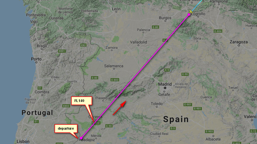
Yesterday I did a flight EGKA-LDSB and intentionally flew a 3500ft level bit after departure, to see how FR24 displays this.
FR24 shows it as 3200ft.
The QNH was 1024 and temp +14C.
What does this mean?
Clearly altitudes displayed on FR24 are not pressure altitudes (which is all FR24 can get from Mode S or ADS-B) corrected for local QNH.
Peter wrote:
Yesterday I did a flight EGKA-LDSB and intentionally flew a 3500ft level bit after departure, to see how FR24 displays this.FR24 shows it as 3200ft.
3200 would be the pressure altitude which is sent by the transponder. 3500 – (1024-1013)*27 = 3203. That is the only altitude FR24 can display unless it has access to the current QNH from all over.
If you flew 3500ft altitude @ 1024 QNH, your transponder would be reporting 3200ft pressure altitude (3500-11*27). So maybe they simply display what planes report.
Peter wrote:
Clearly altitudes displayed on FR24 are not pressure altitudes
FR24 calls it a “calibrated altitude” so presumably they (attempt to) use the local QNH to calculate what that should be based on the transponder’s output. How good the QNH data is for a given flight we don’t know.
I think my above quoted statement is wrong. FR24 does simply use the pressure altitude.
I just never previously looked at my own flights on FR24, in any detail. It’s other people who are doing that 
It would be “interesting software” to correct the PA with local QNH (and temperature), and be doing this for GA only since airline traffic (probably the most watched thing on FR24) is nearly all at FLs. I can’t see them bothering.
What do you mean by “local QNH from temperature/pressure”? In theory it could be the one measured at your position height or your position surface but obviously you need the QNH from local ATC altimeter screen (hopfully they have a good altimeter sitting outside for the physics to match up)