Howard wrote:
Does anyone know why Garmin are holding out on this?
It will never happen (my educated guess). Garmin has the G3X-system (full glass incl GPS) that can display charts of any kind really (but nobody bother doing that), and similar systems comes from lots of manufacturers. Certified GPS is only needed for IFR. A certified VFR GPS system from anyone will never happen. There is no market for it and no use for it either. There is no way Garmin can compete with SD, EVFR and so on, not even with the G3x-system. People typically get a G3X-system (or similar) and pad/SD for VFR and GTN for IFR.
A pad + moving map is the new paper chart (incl protractor, ruler, analog “computer”). It simply cannot be replaced by a panel mount thing because most of the practicalities will be lost. It is a replacement for the paper chart (first and for all), not a replacement for navigational panel mounted instruments (although the functionality of those instruments are made redundant).
A certified VFR GPS system from anyone will never happen
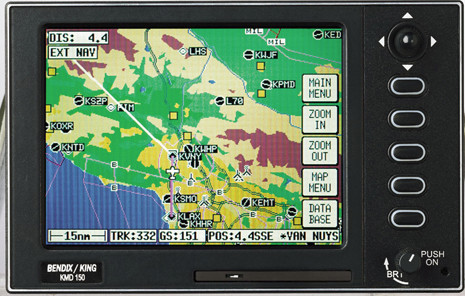
KMD150
Nothing prevents a VFR GPS being certified, to facilitate installation in a plane with an ICAO compliant CofA.
In the same way as you could certify a fitted DVD player (the Socata TBM one is €6000) 
The market is negligible today; that’s all. The KMD150 is dead, along with the Skymap 3C (same hardware) and the company as a whole when it comes to relevance (Skyforce). The KMD550/850 ended up with the same mapdata though, by some historical accident, and you can still get updates from Jepp.
But it’s a tricky Q if GPS was ever introduced into PPL training formally. Curently, any school which wants to totally avoid it can do so. Then, the schools will have to either sort out a dispensation for using Ipads (and make everyone buy an Ipad and one of the Ipad software products) or install certified GPSs (which they absolutely won’t want to unless already installed). The thread on that is here
mh wrote:
people like me enjoy flying with just paper, pen and the aviat
mh, +100 for that comment – There is something amazingly rewarding about sitting at the dining room table the evening before flight planning; and for the sake of example, working out you should see a church steeple after 9.5 minutes flying 320 Deg… and the next day you start your stopwatch, wait 9.5 minutes and see the church steeple from the cockpit window :)
The GPS generation will never experience that feeling of achievement and reward.
@LeSving I don’t get it. Certified machines don’t fly VFR or what? If I have a perfectly good display in the panel, why can’t I get proper VFR data? They could just support data from say PocketFMS (at least in their non-certified line), just like Dynon and others do, or Jeppesen. Leave it to me whether I want it or not. It’s not like it doesn’t exist and they would have to create it.
@Peter IIRC Becker has a certified MFD (not sure as what it’s actually certified), i think it has an integrated GPS receiver and it does have VFR data from Jeppesen. It should also support data from PocketFMS.
Well, use of GNSS is in the syllabus, just like use of ADF. I don’t think the intent necessarily was for everything to be taught. E.g. syllabus mentions carburetor heat. I don’t think it means that a school needs at least one bird with a carburetor. And it’s just an AMC. So it’s up to NAAs what they approve and require. And I as a customer can choose where I spend my money. I don’t see this as that big of a deal. I can read a manual and play with a simulator if need be.
OK, it will never happen again
All our club C-172s (used mostly for PPL training) have a Garmin thing (396 or whatever they are called, with a rudimentary low pixel moving map) “installed” somewhere on the panel, or on the yoke. I’m not sure how exactly they are used in training (I got my PPL ages ago, before GPS), but they are perfectly capable of setting up routes, waypoints and so on. There are courses also, specifically minted towards navigating with GPS, but I have never attended one of those (why would anyone need a course to follow a line?). One of the microlights have a mini iPad attached on the panel. I never use any of those, I bring my own Android pad with EVFR/SD, and so does most everyone else.
Martin wrote:
Certified machines don’t fly VFR or what?
The point is that nothing can beat a moving map on a pad. Everybody flying got one, so the market for more “professional” equipment (certified stuff or not), simply is not there.
Peter wrote:
and make everyone buy an Ipad and one of the Ipad software products
Frankly, this is already sort of happening. I remember that in one school iPad was part of the package with all the materials, I think access to QB, some planning tool(s) and who knows what else.
LeSving wrote:
The point is that nothing can beat a moving map on a pad. Everybody flying got one, so the market for more “professional” equipment (certified stuff or not), simply is not there.
Well tablets are killing the MFD market from what I heard. Which is understandable (and where an MFD is necessary, e.g. weather radar display, you have boxes like the GTN750). But in a small cockpit (think tandem two-seater) I consider a tablet a backup equipment (I don’t want to be using it unless I have to). And it still doesn’t explain why it shouldn’t be possible for me to get data that exists (even from a supplier they already use) for a display I have. Also, I prefer to integrate map with weather or traffic. That can be done on an iPad, but it’s not that easy (it severely constraints both the hardware and software choices). The end result is that there I have a map (running on a quite expensive box) staring in my face which is useless for VFR so I need another device just for that. I don’t find this funny. Even if I had a tablet always with me, it would interest me just for the sake of redundancy.
tablets are killing the MFD market
Probably a number of factors are in play here e.g.
etc
I don’t buy the Ipad explanation as a major factor because that device is not reliable enough for serious usage. You never know when it will shut down due to heat, or just crash.
Peter wrote:
I don’t buy the Ipad explanation as a major factor because that device is not reliable enough for serious usage. You never know when it will shut down due to heat, or just crash
Do you seriously believe that??
Peter wrote:
don’t buy the Ipad explanation as a major factor because that device is not reliable enough for serious usage. You never know when it will shut down due to heat, or just crash.
Sorry, Peter, but that’s just nonsense. Your pet hate for Apple products is well known (heck, you make no attempt at hiding it!), but let’s stick with the facts, shall we? iPads are now used as EFBs by airlines. I know, I know, the pressurized climate controlled cockpit is a different environment from a spam can, but still. At least here in the US there are tens of thousands of pilots flying with iPads day in, day out. And guess what – they don’t fall out of the sky because their iPads aren’t working.