Peter wrote:
an IFR flight knowing it is in Class G can descend without reference to ATC
I will just make sure to be on “procedural service” before doing that in class G
The last time I did it on “radar services” in class G (does this even make sense?), ATS just went ballistic on how I did it (my bad: it was after I asked for help with vectoring to intercept the localizer while in IMC but then changed my mind and went straight/down to the runway once VMC)
My feeling is that for many UK airports with ATC & ATZ but in class G, not knowing which ATS service you receive creates a whole bunch of confusions even for CAT/Airliners let alone a GA aircraft, in France by default you are in the “best service” you can have from ATS, problem solved 
Gallois describes the normal way of doing this. Peter had a bad experience.
Everything is clear
In the UK, going from Southend to Sywell I was under ATC instructhaton. The final instruction from ATC was a heading which would take me direct from the airway to Sywell, not at an intersection. I calculated that I would need to start my descent and requested it. The response was bacally that I could do what I want as I you are now outside CAS.
When flying IFR in France, I try to use English where possible as I would like to move from level 5 to level 6 at my next revalidation.When going from Brest to La Roche sur Yon a similar thing happens to what happens in the UK. The only difference is that Nantes will usually tell me when I am you leaving controlled airspace either horizontally or vertically. As I said before the service is very much seamless as it is if I re-enter CAS.
When descending outside of CAS to La Roche sur Yon they tell me that I will be leaving CAS at FL 55 if I remember correctly, but they will continue to warn me of traffic etc whilst I make my way to the NDB YN or the IAF for the RNAV approach. They will have already given me the QNH and runway in use etc.On the approach or in the hold if using a NDB approach, and before I descend below 3000 ft (although you can usually have contact with FIS well below this, reception of course cannot be guaranteed) they transfer you to the AFIS or at least the Aerodrome frequency as sometimes the AFISO is not present. I either then follow the AFIS guidance or the approach as in the AIP. Of course one has to be more aware of maintaining your own separation when no AFISO is present. If this doesn’t clarify things I am not sure I am understanding your problem. I admit that there are occasions when maybe in switching back and fore between French and English and between IFR and VFR slips in phraseology can be made but are any of us perfect? If you don’t understand something just ask, I have usually found ATS services very helpful whether in French or in English. If I am totally misunderstanding I will need to look out my big dictionary, not a euphamism :)
I think the issue is judging where the 10nm Class E width extends to, when not actually shown.
But in any case, on an IFR flight, I would expect clear ATC instructions. If they can’t give a clearance, they should say something clear like “descend at your discretion” or whatever the standard terminology would be.
I’ve seen quite a lot of funny stuff around Europe but imagine a properly foreign pilot trying to do this…
Are you talking about the class E on the airway (line shown on the map and 5 nm either side of it) from the minimum altitude/level of the airway up to FL115? Otherwise the airspace classes are usually shaded and marked somewhere in the area, usually next to the radio frequency.
Below the minimum altitude in a non shaded areanis usually class G unless it is notified as P R or D.
In class G, IFR begins at 3000 ft minimum and unlike UK demands 2 way communcations with an ATS service.
Usually ATC will tell you that you are leaving CAS just like in the UK but often the same person will continue talking to you as FIS sometimes on the same frequency to the IAF which could of course as in the case of Laval be an NDB.
In the case where there is no AFIS on duty one normally carries out the IAP followed by a circle to land taking into account any other instructions that are in the text of the IAC plates.
Of course if you are under an FIS or AFIS they can not give you clearances, they tend to use words like approved (approuvé) as opposed to authorizée (cleared) or “at your own discretion”. Both FIS and AFIS will usually be providing a radar, traffic and if requested a deconfliction service along with airspace warnings and weather on request.
I hope you might find some of this useful.
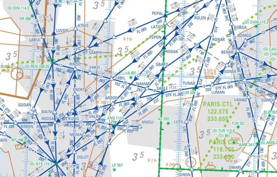
OK; I have seen these. Like the old Jepp airway (“low level enroute”) charts, these are airway maps, which are of negligible use during flight. For one thing they don’t show the lateral extents of Class E, which I believe was Bosco’s main drift (i.e. an IFR flight knowing it is in Class G can descend without reference to ATC)
I think Gallois meant
https://www.sia.aviation-civile.gouv.fr/dvd/eAIP_31_JAN_2019/FRANCE/AIRAC-2019-01-31/html/eAIP/Documents_AIP/MIA/ENR/ENR-6.1/ENR%206.1%20-%20CARTE%20CROISIERE%20ESPACE%20INFERIEUR.pdf
https://www.sia.aviation-civile.gouv.fr/dvd/eAIP_31_JAN_2019/FRANCE/AIRAC-2019-01-31/html/eAIP/Documents_AIP/MIA/ENR/ENR-6.2/ENR%206.2%20-%20CARTE%20CROISIERE%20ESPACE%20SUPERIEUR.pdf
(these links will cease to be valid with the next AIRAC cycle)
Gallois, maybe you are referring to the free VFR charts. These have been around for some time.
Another thread is here.
I can’t find the charts. The SIA website doesn’t show an AIP Enroute section.
If the SIA charts were online, that would be quite useful because they show some stuff which the IGN charts (which have been online for some time – in above linked thread) don’t show. In France, I fly with the IGN charts running on a tablet.
I haven’t a clue what you are talking about, not being IT literate.
It’s just an IFR map of France,(actually 2, one for Upper and one for lower). You can get them on the SIA website by going to AIP en route section. There is also an AIP France App you can get free from Google play(?) which gives reasonably quick access to these charts as well as to all the VAC and IAC plates etc.
Are these georeferenced image (raster) charts? Or is it something for a particular app?
I have access to Jepps for the terminal charts. I used to get the Jepp airway charts also but never found them useful because ATC doesn’t really operate the “airway system” by airway name; they route people within the 10nm or whatever wide corridors.