
Does anybody know how the G1000 defines and calculates MSA? I cannot find it in the manual, and as I understand it there is no ICAO definition for Minimum Safe Altitude (only for Minimum Sector Altitude, and MOCA, MORA etc). Is it +1000/2000ft from highest obstacle +/- 5nm off your active leg segment? Does it consider the full active leg, or even into your next active leg? Does anybody know?
This is from another Garmin IFR navigation device manual. It should be valid for the G1000 as well:
Minimum Safe Altitude (MSA)
MSA is calculated by taking the Maximum Elevation Figure (MEF) from the sectional chart grid that corresponds to your current position.
In areas below 3,000 feet, 1,000 feet is added. In areas above 3,000 feet, 2,000 feet is added.
In the example below, the current aircraft would be considered to be at 7,000 feet. If you are within 5 nm of another grid with a higher MEF, the higher MEF will be used. The MEF on the sectional chart is derived by taking the altitude of the highest obstruction within the grid, rounded up to the next 100 feet, and adding 300 feet. For example, if the highest obstruction is 4,728 feet, the MEF would show as 5,100 feet.
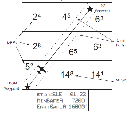
Minimum En Route Safe Altitude (MESA)
Minimum En Route Safe Altitude is the highest MSA for every point between the aircraft present position and the “TO” waypoint with a 5 nm buffer around the course.
The value will be replaced with dashes if there is no valid GPS position, the TO waypoint is blank, or the current position is outside of the database coverage area. In the example shown above, the MESA for the present position of the aircraft would be 16,800 ft. The mountainous terrain would add a 2,000 ft. buffer to the 14,800 ft. Maximum Elevation figure indicated from the sectional chart.
That makes seems to make sense. Thanks!
It does indeed make sense. I am however always surprised about how much higher the MSA computed by G1000 or GNS430 is compared to the MEA or MORA indicated on the IFR en-route chart.
Aviathor wrote:
It does indeed make sense. I am however always surprised about how much higher the MSA computed by G1000 or GNS430 is compared to the MEA or MORA indicated on the IFR en-route chart.
That could be because Garmin uses a definition of “high terrain” which is different from what (most) authorities use. In “high terrain” the separation from obstacles must be at least 2000 ft rather than the usual 1000 ft. Garmin apparently takes “high terrain” to be above 3000 ft, while Jeppesen (and, I believe, most authorities) use above 5000 ft.
That could be because Garmin uses a definition of “high terrain” which is different from what (most) authorities use.
Should not make any difference at FL150 or 190. I need to take a closer look at that.


