For ILS you have the very nice Yaesu 750 but why doesn’t someone do LPV?
The GPS box needs the hex data block which is published in the national AIPs, and there are not enough LPV approaches in the world to make storage an issue.
Somebody ought to tell the programmer of the GPS-ILS app to look into this. I tested the app at some UK ILS airports and while the LOC was spot on, the GS was nowhere near the real one (it was totally off scale at EGHH).
I have written to Yaesu with the suggestion.
You never know… 
Would you hand fly to LPV minima?
Or how do you envision flying the approach?
These solutions are for emergency use mainly. Yes one would have to hand-fly; there is no possible autopilot connection.
How hard would it be to build your own LPV GPS and drive an autopilot with it?
Let’s say the aircraft is a homebuilt so you can do this legally.
Most autopilots will take analog lateral and vertical signals and just follow them, once switched out of HDG or NAV etc mode. The signals required are fairly basic. It’s all been done before; for example there is a US product (discussed here a few years ago but I can’t find the thread right now) which will auto-land an Experimental aircraft in the event of an engine failure. There are control loop stability issues which need to be sorted for a particular aircraft and the loading/speed envelope but the autopilot itself should take care of those provied you supply it with the correct signal range.
Perhaps there is a handheld GPS which has this capability? I don’t think there is one which does LPV, but there are some which will fly a synthetic glideslope, mostly IIRC down to 500ft-1000ft AGL.
An LPV GPS will make use of the hex data block which is published in the AIP for that airport. So you get a properly surveyed trajectory.
Hi!
I will start off with a big disclaimer, I know what I am asking about is both illegal and foolish, however if I get a full electrical failure and there is only low imc in range, I would like to know my options.
Is there anyway to get an LPV glide slope on an iPad?
With a waas equipped gps like the gdl52 the technology is there if I am not mistaken. But is there any software, like Garmin Pilot etc, that could display the glide slope?
Post moved to existing thread
Not as far as I know. It is certainly doable, especially to airports which have LPV because for those the data is published in the AIP so anyone could construct the approach.
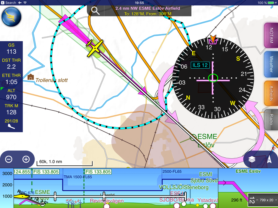
There is also this which constructs a glideslope from nothing. Well, as far as anybody knows, it is done as a straight line from the FAF to the start of the runway.
It may not actually be illegal. It certainly isn’t in the UK, for private flights. The “navigation method” is not legally controlled. Only equipment carriage is.
SkyDemon can emulate ILS using GPS. Of course it is not an approved approach of any kind but it might get you out of a hairy situation.
Just had a run in the sim to see what it looks like. The GS goes away at 800 feet GPS altitude, I assume so people don’t use it for real ILSes.
Dimme wrote:
SkyDemon can emulate ILS using GPS. Of course it is not an approved approach of any kind but it might get you out of a hairy situation.
Do not try. it. The GPS altitude is not very precise on the iPad. Also WGS84 altitude can be different from MSL etc. I think in a worst case you are much better off flyng the vertical part on the altimeter like a non precision approach.