I wouldn't launch without a physical chart. If something goes t*ts-up, your avionics all die, etc., I prefer to have an 'out'.
It just isn't worth the embarrassment. Aviation is full of people giving you dire warnings, and always ready to say "I told you so". I don't like to give them that chance.
I'm a fully paid-up member of Peter's Evangelical Church of GPS. However, I still like to make sure that at any point during any flight, if I lost the GPS, I could continue the flight using visual navigation (or RNAV if in IMC).
Peter 22-Oct-12 08:24 #09 The last time I was ramp checked in Germany I was told that the preferred chart was the DFS chart, followed by the Jepp charts ( updated with hand amendments ) and that a handheld moving map gps was acceptable providing the database was current and spare batteries were available. They also agreed that a hand drawn map would fit the bill if it was correct in every detail.
Gosh that sounds like he made it up on the spot.
Tell him to hang out at Frankfurt and see how many US airliners landing there are carrying a DFS chart
to be fair we were vfr
I always print out all stuff needed for a trip (simply because it is sunlight readable and never needs a backup) but what gets you is when you have to replan something.
On long trips, I used to carry a little printer
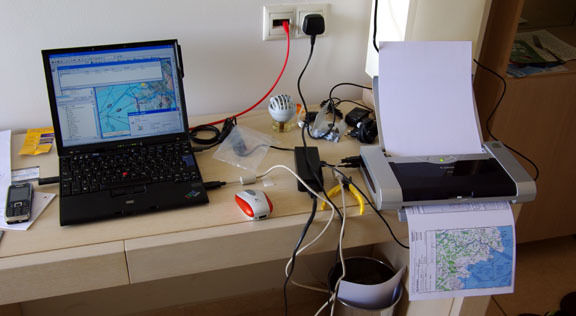
(above pic taken in a hotel room on Crete) which while not very small is lightweight.
However, on recent trips, I moved to using the Ipad, which works OK if you can print stuff to a PDF, which can then be viewed on the Ipad.
However, I would still email the waypoint list (example) to myself and pick up the email on my phone 
One always needs two ways to do everything
The Jepp CD seems only to work with FliteStar - and that has reched the end of it's life.
I can see that Jepp have for a long time been working towards getting everybody piled into Jeppview, but while JV can be used to draw a route (pretty crudely) it cannot generate a plog.
Does this mean that the Raster Charts product will be abandoned?
From EASA OPS Part NCO: NCO.GEN.135 Documents, manuals and information to be carried (a) The following documents, manuals and information shall be carried on each flight as originals or copies unless otherwise specified: (10) current and suitable aeronautical charts for the route of the proposed flight and all routes along which it is reasonable to expect that the flight may be diverted;
Yes, but don't miss the AMC/GM proposed along with it:
AMC1 NCO.GEN.135(a)(10) Documents, manuals and information to be carried
CURRENT AND SUITABLE AERONAUTICAL CHARTS
(a) The aeronautical charts carried should contain data appropriate to the applicable air traffic regulations, rules of the air, flight altitudes, area/route and nature of the operation. Due consideration should be given to carriage of textual and graphic representations of:
(1) aeronautical data including, as appropriate for the nature of the operation:
(i) airspace structure;
(ii) significant points, navigation aids (navaids) and air traffic services (ATS) routes;
(iii) navigation and communication frequencies;
(iv) prohibited, restricted and danger areas; and
(v) sites of other relevant activities that may hazard the flight; and
(2) topographical data, including terrain and obstacle data.
(b) A combination of different charts and textual data may be used to provide adequate and current data.
(c) The aeronautical data should be appropriate for the current aeronautical information regulation and control (AIRAC) cycle.
(d) The topographical data should be reasonably recent, having regard to the nature of the planned operation.
GM1 NCO.GEN.135 Documents, manuals and information to be carried
GENERAL
...
(b) The documents, manuals and information may be available in a form other than on printed paper. An electronic storage medium is acceptable if accessibility, usability and reliability can be assured.
(c) The aeronautical data should be appropriate for the current aeronautical information regulation and control (AIRAC) cycle.
Well....if the aeronautical data must be appropriate for the current AIRAC it looks like we are forced to abandon the annually issued ICAO charts! (Or we are illegal if we haven't updated them by hand).
Will we see these being issued every 28 days now?
Presumably not, so we need to manually update them by hand or technically we are illegal.
In the days before iPad approach charts, I had printed out the wrong approach plates for an airport (because there were two airfields with the same name). The pattern altitude of my chart turned out to be below airport elevation for the one I was going to and it took me a while to figure out the mistake. With the iPad, I carry approach charts for all airports in Europe.
Achimha, what program are you using to store the approach charts in? And where did you buy them from? I have Air Nav Pro on my iPad and Sky Map on the Galaxy Tab, prefer the later but am miffed about the apparent lack of availability for approach charts of airfields outside of Germany.....
Achimha, what program are you using to store the approach charts in? And where did you buy them from? I have Air Nav Pro on my iPad and Sky Map on the Galaxy Tab, prefer the later but am miffed about the apparent lack of availability for approach charts of airfields outside of Germany.....
Steve, I have a Jeppesen VFR Europe subscription and use JeppFD on the iPad (don't really use JeppView on the PC). JeppFD is quite good and includes a free vector enroute moving map that is always up to date. It costs about 300 € a year. German VFR approach charts cost money so I decided to pay a little bit more and get all of Europe in one format. For IFR, Jeppesen his priced prohibitively (ca. 2000 €/year for Europe) so I use the free Eurocontrol charts using RocketRoute's Aeroplates app on the iPad. Sometimes they're quite bad though, made by non pilots for non pilots.
Steve, I have a Jeppesen VFR Europe subscription and use JeppFD on the iPad (don't really use JeppView on the PC). JeppFD is quite good and includes a free vector enroute moving map that is always up to date. It costs about 300 € a year. German VFR approach charts cost money so I decided to pay a little bit more and get all of Europe in one format. For IFR, Jeppesen his priced prohibitively (ca. 2000 €/year for Europe) so I use the free Eurocontrol charts using RocketRoute's Aeroplates app on the iPad. Sometimes they're quite bad though, made by non pilots for non pilots.
Thanks, Achim, I thought as much, but I was looking for (eg) a european version of the DFS Approach Charts which could be incorporated into Sky Map or ANP with as much detail as the German AIP contains because (eg) the UK VFR plates don't show traffic circuit directions nor show any recommended circuits to limit noise, nor do they give you recommended joining instructions, so before I could import these plates into the programs, I'd have to manually add this info and that would be a pain in the proverbial.....
as an instructor i never fly outside the ceases on my map.
i have a win ce device running skydemon - hopefully i can replace that with an android one in the not to distant future.
i insist that my students have an upto date paper chart (and make sure that they give me there out of date copy)
as further back up i have a very old clpyof memory map running on my phone.
approach chart wise i carry copies for couple of local airfields.
When skydemon comes out on android i Will carry a wider range of icap charts in pdf Format on that device too
A friend who runs a pilot shop in the US says that paper chart sales are down 30% in a year. He attributes this to Foreflight and other iPad apps. And this in a country where the charts are cheap, conveniently folded, readily obtainable and of consistent quality.
However, paper charts are not quite as reliable as some authorities claim. There's the one that was almost sucked out of the unfastened C182 door shortly after takeoff from North Las Vegas. The ones that dissapeared under the seats in the huge pile of loose paperwork that accompanies any substantial European trip. Not to mention the ones that might have been left in the back (never actually done that, but heard stories...).
However, I would never fly trusting iPad, or 430, or any other gizmo alone. I always carry paper charts, and draw lines on them. Just in case.