5 per sec? that’s really good. is that with cloudahoy? That’d work though I am 100% sure not as much fun as filming it :)
datapoints should be of the order of 5 per second – good enough for me.
when I bought my PA28 Arrow, I spent a whole day testing it with a few friends of mine on board as “ballast” to simulate max weight.
Instead of using GPS, we attached a go pro camera to the tail tie down ring and visually checked the take off point down the runway against the known distances on the runway. Results were very accurate. It is difficult to measure take off distance using gps/software because the data points are not frequent enough to precisely know where you lift off the runway. When you film the whole thing with an external cam strapped to the underside, you get very precise measurements by watching the video and noting your location on the runway from a known point where you started to roll. We then carried on with landing distance measurements the same way. I used GPS data though to calculate best climb, best glide performance.
Yep FF and Google Earth work well. That CloudAhoy thing allows for a more detailed analysis of the data. Then again, it costs money…
DavidJ wrote:
Using gps, I wouldn’t have expected the accuracy of the aircraft on the vertical plane would be anywhere near good enough
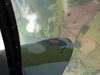
Using Foreflight Track Log generated data worked fine for me. You can see a number of data points at the same elevation, then one that’s higher, followed by more that are higher still. Lift off occurs between the two obvious elevation change points and the take off run could be estimated between them. IIRC I exported the data into Google Earth, with graphics like that shown below, and measured point to point distance on the screen in the usual way. It was not rocket science.
I thought about using a skiing app for this but you’d need your passenger to hit the stop/start at the right points.
You could write a script to do it from the logs after the fact.
Better still would be to use the logging feature of something like a Garmin G5 since that also includes values seen from the pitot/static system as well as GPS.
Using gps, I wouldn’t have expected the accuracy of the aircraft on the vertical plane would be anywhere near good enough, considering the tolerances required. IIRC, the accuracy is ‘only’ 5m on the horizontal, so due to the location of the satellites in orbit wouldn’t expecting anything approaching this on the vertical plane be optimistic?
a_kraut wrote:
It worked perfectly well with the Garmin 496
A while back I walked up a couple of flight of stairs with an old 496 but didn’t see any change in altitude?
Any GPS app which can record data at time (not distance) intervals can do this. Set it to say 1 second intervals. Then the data (GPX, KML, etc) can be plotted and the distance measured. Not exactly convenient though.
For landing distances, it is not easy to do this, because small geoid errors will prevent the software detecting the touchdown point accurately. This is the problem I always get on my flying videos (which usually have a GPS position+altitude) subtitle). Correcting the geoid error at the start of the flight is easy but the error can be 10-20ft different after a long flight.
There is an App / website called Could Ahoy (must have some Czech backers / software guys…) that translates the data coming off ForeFlight into a comprehensive flight debrief. It’s great for IR training (I discovered it a bit late, alas). It can also read your GPS data directly, IOW you can log your flights directly in the App, although I’ve never tried that. It’s a subscription based thing, about $ 60 p.a. and a free one month (?) trial.