
CATHY is a useful one ;)
This one reminds me of some 100kg peasant woman, like the one here, walking up the Albanian mountains carrying a goat under each arm
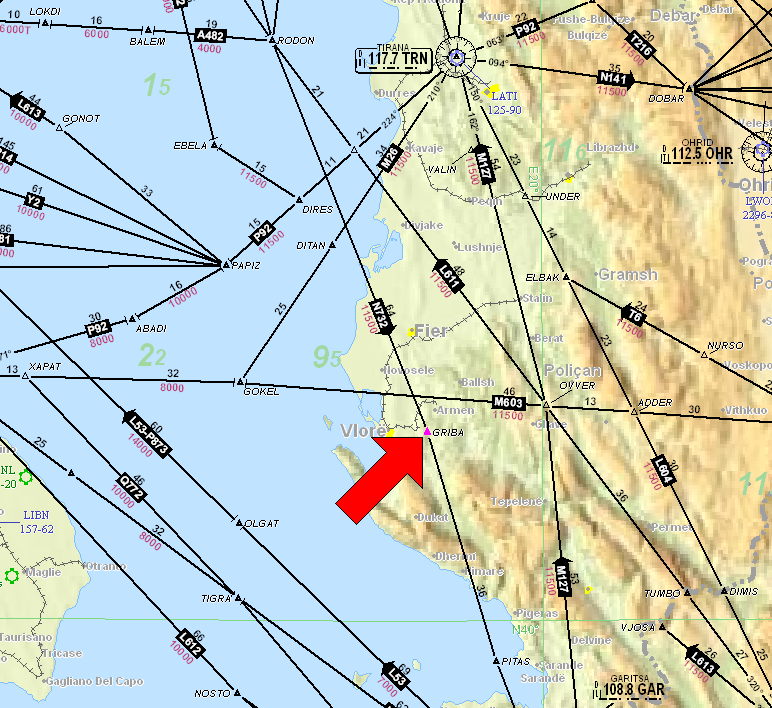
The one to the right of it, ADDER, is also quite accurate. May also be descriptive of some of the local business community 
And yes I used to fly down there VFR, 2004/2005, and the IFR waypoints are used universally, as they are in Greece where you file VFR flight plans on the IFR routes e.g. A14.
I always wondered what is the standard for VFR/IFR Flight Plan routes but it seems country dependent?
I only put airports and nav aids and fly close or just do direct , town names did not fly high to describe the route when I tried to file by phone in France (spelling GPS coordinate would be more fun)
My answer to the original question is : Yes, you can.
As you noticed, Navaids are too rare to describe a route using only them.
As said above,
I didn’t dare using them when I first read EuroGA but since I started, I didn’t look back. And I feel like a big boy now
For zone crossings, do not file waypoints inside the zone, just put a direct route through it, and expect to be given some VRPs (on SD too).
In France, using city names works (if the city is not too small), but as you noticed, if you use a city as a waypoint, SD fills the FPL route with coordinates, not the city name.
One more reason to only use Navaids/waypoints.
Feel free to ask if you have other questions like these.
I’ve always used IFR waypoints principally because they’re in the GNS430 database and visual reporting points aren’t. This way I can have exactly the same route on the GNS430 as I have on SkyDemon.
I don’t really like VRPs anyway because unless they are very obvious, or you’ve been there before, then identifying them visually can be a bit of a guessing game.
Most LARS controllers know where the IFR waypoints are and are happy for you to use them. London Info sometimes struggle, but then they are FISOs and are covering a large area. They are fine with the frequently-used ones like ORTAC, ORIST, etc.
To go France to Corsica, you have funky ones. LONSU is a corsican sauvage, MERLU is a fish, OMAR is a lobster, TORTU is french for turtle, COPPA is another sausage, MOULE is east side corsica and means mussel. i would really enjoy fly these:).
And yes, apart from these specific routes, atc is not really fond of vfr using 5 letters points. My school told me not to do that as good practice.
By IFR you probably mean the routing using IFR waypoints. That is not to be mixed with an actual IFR flight. But regarding use of waypoints and planning VFR: I think any dislike from “IFR waypoints” must come from old days as there are no good reason not to use them VFR too. They are just a point on a map and with todays GPS accuracy its much better than referring to some weird visual point that is pure guesswork and potentially hard to pronounce.
I use mostly 5-letter waypoints in VFR flight planning if going from A-B. It is usually much easier to plan a flight that way and to enter it into a GPS too. Usually there are also these waypoints on the borders between countries which will give ATC/Flight info a good idea about where you expect to enter and leave FIRs. If weather permits I like to get up around FL 85 or FL95 which usually separates one from the VFR traffic below just cruising around or doing airwork. This is also a good crusing altitude for non-turbo aircraft.
Mostly I find ATC very helpful when you have a flight plan taking you from A-B using these points. In many of the eastern european countries they will treat you like IFR traffic clearing you to a waypoint far away taking you through various terminal areas and then just handing you off from one controller to the next like in IFR flying. Last week I did a VFR flight from south Romania to Denmark using probably 25 waypoints in flight planning and ended up flying in straight lines using probably only 5-6 waypoints.
However in VFR flying one must always have a plan B should you not be allowed to cross an area or cloud show up at your cruising altitude. This uncertainty and responsibility makes VFR flying much more stressfull than IFR I think.
BTW: Germany fx has a very VFR friendly airspace structure considering the number of people that live there. You can easily cross large distances VFR with only an occasional class C/D terminal area going all the way up to FL95. Other countries have widespread class C/D areas from up high going down very close to ground, Italy and Croatia being such examples. Even worse in areas like around Amsterdam and London its Class A down low where VFR is not allowed.
I use combination of VRPs and IFR waypoints when building my VFR routing on Skydemon. The VRPs are being used for CTR crossings and departures/arrivals as VFR departures and arrivals are much different than IFR departures and arrivals and VRPs around airports are there to separate the VFR traffic from IFR traffic. Bigger airports typically have VFR arrivals and departures separated from IFR arrivals and departures and are most likely based on VRPs. Enroute it is much easier to use IFR points and there is no problem for the ATC to separate you from IFR traffic as you typically fly much lower.
Tried it a couple of times, but saw no advantage, just more to remember of the abstract kind.
If you have a panel mouted GPS possibly connected to an AP with GPSS then you’ll learn using IFR waypoints as route points fairly quick. I’ve done this for the duration since I have my GNS430 (now W). It’s not particularly difficult to do in planning programs like Easy VFR and it makes generating the flight plan in your GNS so much easier. Apart, in some countries you will fly waypoints if you want or not.


