
@Sebastian: Can you use Weather Underground as data source instead of DWD (or as complementary service) to expand coverage for rain radar?
You mean @Sebastian_G
Can you use Weather Underground as data source instead of DWD (or as complementary service) to expand coverage for rain radar?
For the ADL weather we already use a combination of sources. The central European part is licensed through DWD. The data comes from all the differnet national weather services but DWD is the one selling the combined data at the best price. But we also add coverage from other national provider who provide the data free of charge.
I did have a look at the weather underground data which they display on their website and I am not conviced. Just have a look at the screenshots below:
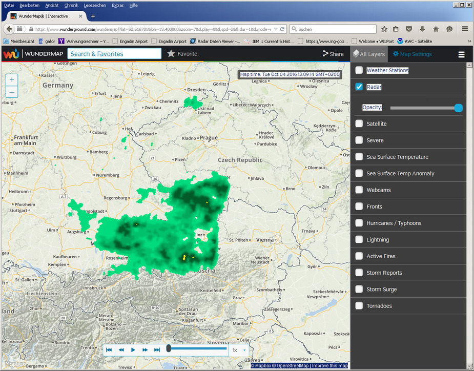
Seeing this image I might be temped to route a flight via Vienna. But then the ADL radar image shows this:

Some might think different but I think an aviaiton radar product has to indicate the current coverage area.
Just to give an example this is the current radar image from Norway. They have two radar station in maintenance. How is one suppose to work with that data without the coverage information?

And another example. Imagine flying from Brest to Portugal. Looks good so for on the Weather Underground map:

Now have a look at the ADL radar images:

You already see there is a coverage gap on the ocean and there is some light echo on the Spanish radar also. So the Weather Underground signal is missing the coverage information and the Spanish radar coverage as well.
Finally to confirm we overlay the satellite infrared image. We can see this front extends much further south than the initial radar image suggested. It is almost certain there is weather further south than initially assumed which should be avoided:

It is annoying that all the sat phones providers are neither transparent about their service plans or about their data rates in my experience.
In a different world I have Fleet Broadband which from a usability point of view provides stable streaming services just about any where in the world that arent noticeably different to home services but the service plans are frighteningly costly. The majority of services fall a long way short of streaming and are painfully slow and it is often difficult to work out the true cost of a call be it to or from the handset.
AFAIK Wunderground shows you the radar sites only for the US, Canada and Australia.
Wunderground also has an augmented radar mode offering lots of additional information that would normally be outside the scope of radar coverage. Wunderground covers the US, lower part of Canada, Caribbean, Europe, Australia and some odd places in the Pacific ocean connected to the US, but best to check the Wunderground / Weather Underground website for that.


Does that augmented mode appear in your app?
this is real interesting can someone give me some feedback or eve better real experiance about the sat phone costs for hardware and useage thanks


 thanks for correction

