Ibra wrote:
I still think there is a lot of confusion among pilots on what “GAFOR weather/routes” actually means?
It’s not random at all, it is a pretty precise forecast for a clearly defined route. Nothing ‘random’ there. As has already been discussed in this thread, there is a difference between the Austrian and Swiss GAFOR and the others. In Austria and Switzerland these routes are extremly useful for Alpine crossings when the the flight is either VFR only or in case of icing in the wx above.
In any case, it’s not pertinent to this sad accident, as it happened on a gin-clear day. No GAFOR required.
It seems we have a bit of a consensus that this unfortunate pilot did these things
I’ve taken off, nil wind, one up, half fuel, at 7600’ in a Pa28-161, with density altitude higher. (Gunnisson, Colorado.) No problem, although due to a C182 on circuits I took off towards the hills and had to turn 180° at lowish level as ground was rising at climb rate.
I find the suggestion that he failed to notice rising ground unlikely, with his wife on board to monitor.
I prefer to fly below the mountain tops, unless crossing the ridges.
Ibra wrote:
I still think there is a lot of confusion among pilots on what “GAFOR weather/routes” actually means?
I now personally think it is just a random weather forecast that is attached to a random valley route and cannot be relies on for “serious planning”
I attended a seminar organized by the austrian CAA and the person in charge of GAFOR held a presentation. A lot of (meteorological) effort goes into GAFORecasts and they are the backbone of non pressurized piston flying in alpine areas. Obviously the codes D (only for pilots trained in visual navigation) and M (only for pilots very well trained in visual navigation) mean exactly that. My homebase has an MSA of 8000+ feet, flying here always involves terrain, and still I’d never fly a GAFOR route in a fast(ish) tourer under those conditions. It’s difficult to identify valleys when you follow along on a moving map when there are perfectly clear conditions fromm 2000ft above, let alone anything less down low. You either know the topography or stay away.
While I don’t have hundreds of hours in the exact plane type like Bosco, I do have 300+ hours in other PA28s, so I’ll offer my datapoints.
Of course a downdraft due to convective weather or mountains changes the equation significantly for all variants, the positive 3-400fpm you had a second ago become negative despite swiftly applying full power and Vy.
Neither POH make any mention of a Vy or cruise-climb IAS varying with altitude or weight, even though in practice you quickly notice it is a necessity (with the risk of stalling in the back of one’s head, so a target number would be nice to have).
Mooney_Driver wrote:
Maybe someone got chilly in 6000 ft and they put it on without realizing it was emitting CO?A PA28 is a greenhouse in the sun. This summer I have flown with all the outside vents open (and the heater off, obviously) when OAT was -4°C to maintain 20°C in the cabin. I also like the idea of flooding the cabin with fresh air for that very reason, but I never needed long pants or a sweater.
WarleyAir wrote:
Anybody else had an iPad ‘shutdown’ in flight ?I run an iPad Mini 4 in a RAM support in front of the right front seat, with the RHS outside vent blowing straight up, and it has never happened to me. I regularly check the temperature on the back of the case and it does not get hot to the touch even if it’s in the sun.
Peter wrote:
misread some altitude reference number on Skydemon (is there a clear screenshot showing this?)I find SD pretty clear with the pass’ altitude and showing the powerlines:
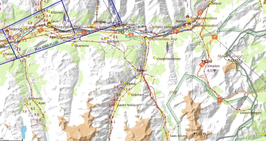

What might be getting missed here is the nature of the valley floor topography for this route.
We have no idea what has actually happened.
But following along the possible lines of CFIT, the route from Lausanne passing Sion to the pass is very straightforward. The valley is wide and with clear skies, calm winds, and weak updrafts/downdrafts wouldn’t be that challenging. The valley floor elevation is +/- 3000ft all the way to Mund.However it starts to climb very quickly from there, the valley tightens and begins to twist and turn.
Based on hearing that Alpine flying is not easy, its possible by Raron (coming from Lausanne), to be wondering what all the fuss is about.
However within 5 miles you need circa another 4000ft.
If this wasn’t fully understood it would be a problem.
In those conditions an Arrow isn’t going to achieve that, and it’s getting tighter for a 180.
A turn is available but if already under pressure may not seem like it.
Coming the other way, kinda starts out a little more hostile sooner, and sort of gets easier after Simplon.
I have no idea what happened but if we’re not talking aircraft failure then this would be my guess.
RIP
Snoopy wrote:
still think there is a lot of confusion among pilots on what “GAFOR weather/routes” actually means?
I now personally think it is just a random weather forecast that is attached to a random valley route and cannot be relies on for “serious planning”
I attended a seminar organized by the austrian CAA and the person in charge of GAFOR held a presentation. A lot of (meteorological) effort goes into GAFORecasts and they are the backbone of non pressurized piston flying in alpine areas. Obviously the codes D (only for pilots trained in visual navigation) and M (only for pilots very well trained in visual navigation) mean exactly that. My homebase has an MSA of 8000+ feet, flying here always involves terrain, and still I’d never fly a GAFOR route in a fast(ish) tourer under those conditions. It’s difficult to identify valleys when you follow along on a moving map when there are perfectly clear conditions fromm 2000ft above, let alone anything less down low. You either know the topography or stay away.
I’m all agreed (at home the MSA is + 12’000)
GAFOR is very reliable to know the conditions on a route.
GAFOR is a forecast on an identified route and a given altitude.
The GAFOR can be indicated as M or X and the road is still feasible at a higher altitude or by another nearby pass. But do not go into this game here
Another thing, GAFOR is not necessarily a mountain route. For example, in Switzerland the route Geneva – Montreux is not at all in the mountains. The Montreux – Sion road is in the Rhone Valley but it is not at all mountain flying
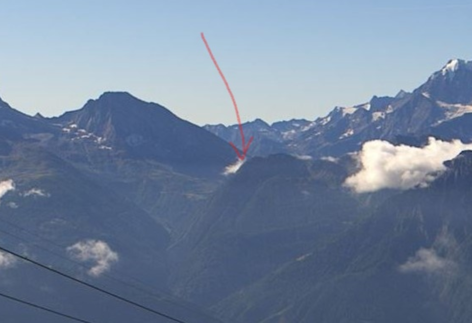
At the last recorded position in the FR24 log the apparent azimuth and elevation of the sun were 116 and 40 degrees (JPL Horizons output; Suncalc.org link). The azimuths for the final five track segments were 110, 118, 124, 130, and 135 degrees (GeodSolve output based on FR24 log).
So he had the sun shining straight into his eyes as he was flying into the canyon.
That Skydemon config is pretty subtle. I would bet on 99% of SD users not knowing this stuff. Certainly none of those I have met or flown with would have done.
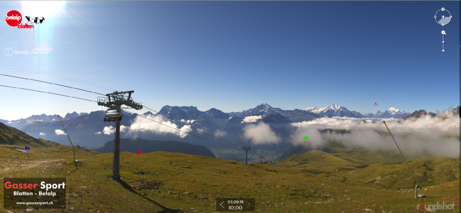
https://belalp.roundshot.com/hohbiel/
(the cam is about 8,800 feet)
I don’t think the sun should bother him