
Yes, but can you make user-defined waypoints “fly-over” rather than “fly-by”?
No, just tried it. Yes, you could define the whole arc (a bit like using Bezier curves, though for LFMD rather than LFMU). But it’s all a bit painful. I think switching to SDVFR (or other VFR app) at PIBON is the answer, and just focussing on staying outside the nimby zones.
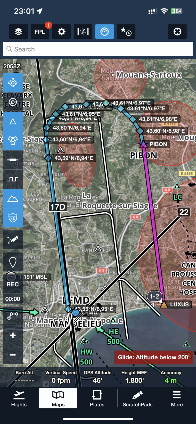
LUXUS PIBON 43,603/6,982 43,606/6,979 43,61/6,974 43,611/6,967 43,611/6,959 43,61/6,95 43,608/6,946 43,607/6,944 43,604/6,942 43,6/6,941 43,594/6,942 43,547/6,951 LFMD
There is one other thing which gets forgotten when people invent such “precision visual maneuvers”.
We are talking about VMC and VFR maneuvers which means, you need to be OUTSIDE with your viewpoint watching for traffic.
What this kind of stuff does is get people to fly pseudo instrument procedures following either ipads with geo maps or some magenta line rather than watching outside if they are about to hit anyone.
When this discussion was going on about Hangelar it was clear to me that I would NEVER visit a place where a circuit has to be flown to ILS precision, mainly because it would be dangerous as hell when all the pilots are staring on their GPS’s rather than see if there is anyone else in the circuit doing the same.
We should never forget in such discussions that NIMBY’s will NEVER be shut up by airfields giving in to their demands until the airport is closed. It’s NOT about “gentlemen’s agreements” (most NIMBY’s do not qualify for that term by the very fact that they are NIMBY’s) it is about extinction. Hence, creating such precision flight tracks to satisfy NIMBY’s is an exercise in futility when it comes to pacifying them as well as a shot in the foot of the actual airport by giving them something without getting anything in return.
VFR/VMC maneuvers have to have a certain degree of tolerance to be reasonably safe, trying to force them onto magenta line tracks is imho a very unsafe thing to do.
We are talking about VMC and VFR maneuvers which means, you need to be OUTSIDE with your viewpoint watching for traffic.
Yes, but in the case of LFMD, you are in Class D, and they separate the VFR traffic in the circuit at 1000’ and only IFR expected to follow the track at 2000’, so you are separated.
Yes, you could define the whole arc (a bit like using Bezier curves, though for LFMD rather than LFMU). But it’s all a bit painful.
I found one of the difficulty of this approach for me is to set up the FMC with the approach, the points, etc. I use a G1000, and I somehow struggled a bit initially to just get it to add/follow LUXUS/PIBON, I can do it now given I went a few times, but I can’t really picture myself getting the point from foreflight or a saved flt plan while you fly the approach, and while you are separated, you still need to look outside to check mougins, highway intersection etc…
So in practice, i think having luxus and pibon then doing the turn visually after pibon works well for me.
Mooney_Driver wrote:
We are talking about VMC and VFR maneuvers which means, you need to be OUTSIDE with your viewpoint watching for traffic.
We are not talking about a VFR manoeuver. A VPT is an IFR procedure, so you have no greater need to look outside than you do in other phases of IFR flight.
We are not talking about a VFR manoeuver. A VPT is an IFR procedure, so you have no greater need to look outside than you do in other phases of IFR flight.
This neatly brings the discussion back to the original post – Point A and B are not defined by reference to RNAV waypoints or ground based navaids. You should have to be looking outside to identify these.
This of course is a farse because all of the bizjet crowd flying this regularly are going to find a way of constructing the approach in the FMS by whatever means necessary.
Point A and B are not defined by reference to RNAV waypoints or ground based navaids. You should have to be looking outside to identify these.
Quite apart from the difficulty of doing so with any degree of precision, Point B isn’t identified in any way that would LET you identify it by looking out of the window. The closest thing is a “big white tent” which (a) was only ever somewhere nearby and (b) isn’t there any more.
You know it’s on the runway axis, but neither Jepp nor the AIP tell you what distance it is from anything.
This is what Google Earth shows when I import KML file from my landing there. It’s not about the ability to fly precisely or not, it’s about refusing to precisely define the points in space and the inconsistency of overflying corridor distance with EASA rules: A is defined with visual clues and altitude between 2000 and 1700 feet, B is defined with visual clues, DME distance and precise altitude of 1700 feet.


