Peter wrote:
The data has to come from somewhere and there is only one public source – he NASA SRTM data.
Where does Google Earth get its data? Its terrain elevation resolution is not worse than 1 foot. At least not where I live…
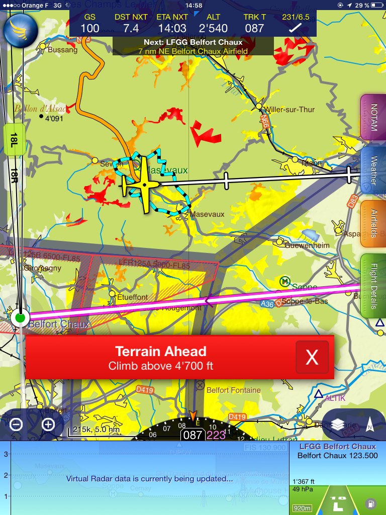
I’ve tested Terrain Safe Mode in Skydemon today for the first time. I have an iPad mini (first generation). It doesn’t work usefully. You could believe that it works, because it paints some red and yellow bits, but most of it is clearly missing. There is plenty of terrain around the plane at that position, yet it shows in “standard green”. At no moment did I get the “whole picture” about terrain. I find this is a quite dangerous failure mode.
Rwy20 EasyVFR/PocketFMS has quite a good terrain awareness/airspace vertical and hazard display. Will try and get a few screen shots next time am near the mountains.
This has nothing (or not much) to do with SV. It is a reply to the posts about SkyDemon and other terrain databases, which still appear on this thread. If they got moved to a new thread, this one can be moved as well. Otherwise I won’t open a new one because it would be out of context there.
The point was that failure modes are manifold and not always obvious. It is not only about shutting down or losing GPS reception.
And no, I haven’t contacted SD about it as I only just got home and posted this image before going to bed. But so what – they may fix this bug and it’ll be the next one that kills you.
Of course the area is red in Easy VFR, we were flying inside the valley! And yes, I chose that image with the Ballon d’Alsace and the “Terrain Ahead” warning to clearly show what’s wrong with that feature. I have more screenshots as well. DB was updated today before the flight.
And I hope our fellow pilot wouldn’t mind us having this discussion, if it can help enlighten those who are still alive. So I don’t want to see your point about being “disrespectful of our colleague” by discussing these issues, even if they are unrelated to his flight.
I have to say GP with terrain on works very well and the external GDL39 GPS. But in real terrain I would have the MFD on the TAWS-B page without a doubt. But I would certainly not use it to thread a needle in IMC.
As I wrote before:
If the X-Plane worldwide database is say 50GB, and it was when I bought it some years ago for my son’s sim, you cannot possibly get a European database that’s any good (say within 100-200ft) in a few hundred MB.
And what needs some GB in a tablet will equally need the same in a panel mount product.
So I wonder how good this stuff really is, for emergency terrain avoidance.
Interesting Q about google maps – they are indeed quite accurate in elevation. But we can’t know their database size. It could be 1000 terabytes, for all we know… The maps don’t load fast even on a 30mbits/sec ADSL connection and that is just one 1600×1200 screenful.
A lot of their data comes from survey flights, usually done at 5000ft AGL. They survey companies sell this to various customers e.g. satnav vendors.
No app will have a 50GB database, but on the other hand they don’t need as detailed information as X-Plane.
X-P isn’t anything special in terms of terrain accuracy. Flying it around known local area it merely shows “what there is”. For SV purposes you would want nothing less.
The Garmin Pilot worldwide 10 arc second terrain database is a 929MB download.
My worldwide G1000 terrain database for the G1000 is 4.9 arc second. Garmin G1000 SVT won’t work without 9as or better terrain.
This page explains the translation to meters: http://vterrain.org/Misc/usgs_data.html
This 50GB figure for x-plane that keeps getting mentioned is meaningless.
X-plane’s worldwide scenery is indeed 50GB+ but that includes visuals, not just terrain.
Rwy20 wrote:
I’ve tested Terrain Safe Mode in Skydemon today for the first time. I have an iPad mini (first generation). It doesn’t work usefully
The SD terrain safe mode is superb and I was baffled when I saw your screenshot. Took me a minute to figure out what was going on.
Try changing to SkyDemon 2 chart format where things look as you would expect. Or turn off the ‘trees’ layer.
Also, in case you haven’t noticed, you can tap the settings cog and ‘Download high-resolution terrain’ when in planning mode.
I’ve reported this.
The Garmin Pilot worldwide 10 arc second terrain database is a 929MB download.
My worldwide G1000 terrain database for the G1000 is 4.9 arc second. Garmin G1000 SVT won’t work without 9as or better terrain.
This page explains the translation to meters: http://vterrain.org/Misc/usgs_data.html
Many thanks Jason for that very useful post.
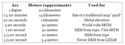
So, 10 arc seconds is a horizontal resolution of 300m (1000ft). I wonder how big a mountain peak could be contained within that?
Even the 4.9as resolution puts SV into a category which I am sure would surprise most people, some of whom believe you can do a zero-zero landing just with SV.
OTOH, as I mentioned in my earlier post (was the OP in this thread, before I had to move over a load of OT posts from the TB20 crash thread) there must be some “blending” around airports which are surveyed much more accurately, otherwise SV would look terrible there.
BTW the Garmin 496 European terrain (the TAWS function) is just over 300MB. I have tested it and it is pretty good but the algorithm is sometimes prone to generate false warnings, and if in IMC one wonders what one would do about that. For example I got one on an ILS to St Gallen and any “terrain” was a good number of miles away.
I’ve reported this.
And you Steve are a SD expert, one of the beta testers! Imagine the normal user. I’ve flown with a few…. There are too many features in that app and that is far from being just my view…