GA_Pete wrote:
30ft per millibar. 27 in ISA.
QNH of 1000 is 13 below 1013, so effectively 390ft
difference from a Flight Level.
If you fly at 4700ft Alt, on QNH below a FL50 TMA you’ll bust it by 90ft vertically.
Hence the advice from many instructors to fly on a setting of CAS you are flying under (QNH, if the CAS above is ft AMSL and STD if FL).
It’s all a cockup since
In the case of #1 when I call up the ATC unit, I ask them to verify my TXP return and I get all that on the mp3 recorder.
alioth wrote:
I suspect that most moving map GPS software won’t warn you either, because it won’t know the QNH and will just take FL55 = altitude 5500.
Gliding navigation software use the proper pressure reference in accordance to the controlled airspace when fed barometric altitude (typically from FLarm or vario).
You can enter QNH or it automatically derive QNH from your take-off elevation.
Peter wrote:
He said yes it should be just 1013 but lots of people do it using some QNH method and get it wrong, which is why he put the QNH based method into the exam!
Which is completely absurd – it’s codifying and encouraging the wrong procedure! Instead the question should be asking why is calculating from the QNH a bad idea and will increase the risk of a vertical bust. Such a terrible take. It’s really frustrating because in some ways the CAA is doing the right thing (recognising the value of and encouraging the use of moving map GPS products that depict the airspace, instead of using “traditional methods”).
Then again, it doesn’t really surprise me given that at the moment we can’t get any new BGA inspectors because the BGA (British Gliding Association) basically said the question bank for the now-mandated CAA test is simply not fit for purpose, and the BGA has no confidence in the CAA’s oversight.
alioth wrote:
The trap for the unwary is now that next section of airspace – the FL55 bit – is now almost a full thousand feet lower than it normally is due to the low pressure system and is no longer a “step up”.
What trap?
The transition layer is always required to be min 1000’. Therefore you cannot be at FL55 if you have not passed the published transition altitude. If you pass the transition altitude you should set your altimeter to 1013 and then ensure your flown flight level is appropriate. Don’t forget that the transition level is not fixed and changes as air pressure changes. If FL55 would “eat into” the transition layer’s min 1000’ then FL55 would not be available and cannot be flown. A higher flight level would be the transition level. As long as you maintain an appropriate altitude with a correct setting in your altimeter you can’t bust any CAS limits.
I don’t understand what the issue is.
The issue is that with a QNH of 965 you can fly from 4400’ altitude underneath a 4500’ base of CAS laterally into adjoining CAS at FL55 at FL57.
No one controlled will be at FL55 because as you rightly say the transition will have been moved up, but I bet you still get busted for it.
Yes you get busted regardless of traffic – because of the +5000ft -5000ft artificial cylinder, 5nm diameter (or radius – NATS pubs vary on this; see previous posts) which is placed around any infringer, and which ensures most busts are “serious” because +5000ft puts you next to some airbus at 9000ft. I got sentenced to gasco for one of those.
Interesting video.
I didn’t know this bit:
eurogaguest1980 wrote:
Interesting video.
The video didn’t make any mention of the real issue. The airspace limits are based on barometric altitude, not real altitude as provided by GNSS. Depending on temperature the two can differ substantially. Even with the highest GNSS accuracy the difference may very well be large enough to cause an infringement if you depend on GNSS altitude only.
It’s a bit worrying if pilots are not aware of this – particularly pilots making a video about infringement and GNSS altimetry. I know for sure it’s in the PPL syllabus.
The two don’t differ much at typical UK GA altitudes i.e. SFC to 2000ft  What atmospheric conditions would you need for say a 200ft error at 2000ft? (the UK CAA man will bust you for 200ft into CAS – plenty in the MOR summaries I get).
At say 15000ft you can see 700ft easily.
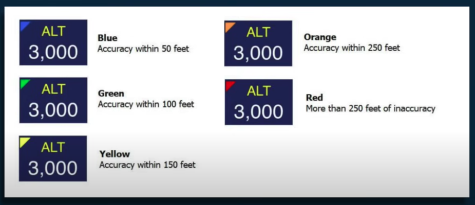
That colour table is weird. I have done tons of software for GPS and have never seen anything giving such an estimation. They might be doing some calculation based on VDOP i.e. purely on the geometry of the constellation.
Normally you get way better but also the Ipad can do funny stuff, reportedly.