I’m training for the MEP rating with a DA42 (maybe my next airplane). I’m looking for a Skydemon aircraft profile file, so that I don’t reinvent the wheel.
The problem with the Italian TMAs has been solved.
First, about two years ago, they finally understood how they were intended to work and how the information was published. (Still took them way too long it was a disgrace). They then started to show the TMAs more or less correctly.
Then, finally, last year, Italy totally changed the design of their two big TMAs which used to have those dreaded VFR sectors, thus making life even easier for Skydemon. First Rome, and more recently, Milan. You will find threads which discuss both of them in more detail. These changes were probably triggered by SERA, too.
SkyDemon still has “errors” (some in France), but all in all, it’s now a program I use, like and recommend.
Autorouter (router.euroga.org) has a DA42 template. Create your aircraft using this template, then create a route, then download the Skydemon file for that route. When importing it into Skydemon, the aircraft profile gets imported as well.
When I plan a route in SkyDemon I see all TMAs. When I fly however and there is a TMA above me (e.g. I fly at 4000ft and TMA starts at 5500ft) it is not depicted on the chart. Is there a way to show the TMA and it’s limits in flight even though I am outside of it? Do I assume correctly that it will show up if I am close to it?
Yes, when you are climbing you should get an alert and a frequency to call to obtain clearance to enter the airspace.
Maybe Check
Setup, Mapping, Map Layers, When Flying, Hide features higher than setting
It is all in your options. It will show up when you are close to it (because in your options you have to define what distance you want to see. For example: everything 2000ft below and 4000 ft above you – you can change it easily)
What is important: SD doesn’t know the QNH and it will not adapt (that can be a difference of several feet) . You have to see the border of the TMA and zones yourself, because sometimes SD will show you are inside or outside, but you are not (if your altitude settings are correct). So don’t rely only on your SD, the borderlimits are correct, but the flying plane is not adapted to the QNH.
I think there is a topic about this here on EUROGA
What loco said….you can set the upper and lower cutoffs for airspace dipiction for both planning and for flying…I always show everything by setting the limits >25,000ft… And as James says, even if you have the limits set so that the higher airspace is not shown, you will still get an alert provided you have enabled alerts in the settings.
Vieke, good point…I think the problem is when flying in the Flight Levels on 1013 your true altitude may be off by several hundred feet as you say, whereas SD depicts the vertical limits as height above sea level (altitude)… So yes, it is important to be aware of this trap when flying in the FLs…
Thanks a lot, found it.
Skydemon corrupt data
I have this problem every time I go flying with SkyDemon:
When I am on the ground with Wifi connected, SkyDemon downloads and interprets all data successfully and doesn’t have any errors.
When I am in the airplane with 3G/4G connection, SkyDemon gives me these error messages:
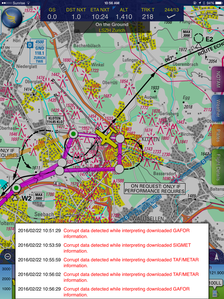
They pop out all the time until I lose connection which is unpleasant and distracting. Any idea what causes them and how to get rid of them?