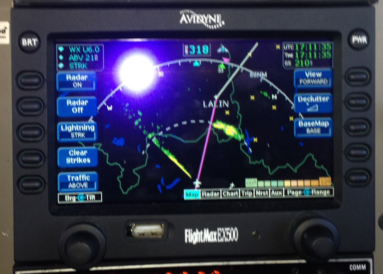
Yes we also have on board radar. It works white well up to 40NM but will not go any further. Here is a picture which shows the soutern two cells of the weather system shown above at the 40NM line. But the radar can not see behind those cells (the echos on the left side are from the prop and must be disregarded):
Sebastian_G wrote:
the echos on the left side are from the prop and must be disregarded
So your radar pod is under the right wing?  How did such a bad installation happen? Was it added later? The prop changed?
How did such a bad installation happen?
Explain how you would avoid that in a SET. Lengthen one wing with a 50m boom?
Problem is, the obvious spot in a plane for the weather radar is already taken by that useless ventilator in a SET
How did such a bad installation happen?
The radar on the PA46 is a factory installation by Piper:
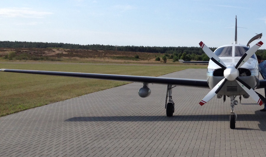
Having it on the wingtip like the PC12 or at least further out like the new Piper M600 would probably help reducing the noise on the left side of the screen.
An update today on the app store for ADL Golze: support for infrared images 
Looking for help to interpret this ADL WX image
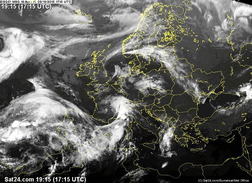
Places with a lot of sunshine tend to have a different type of bad weather. Around Barcelona (LELL, LEBL) there were a lot of TCUs and CBs during the last few days. I am looking at today’s weather as a learning exercise. This is what the current ADL image looks like:

The corresponding METARs are:
LELL 031600Z 23005KT 200V260 9999 FEW020 22/13 Q1015
LEBL 031600Z 23011KT 9999 FEW020 22/16 Q1014 NOSIG
Field elevation at LELL is 485’. That means the FEW020 comes to about 2500 MSL. Their very high traffic pattern is at 2000 MSL.
There are a few webcams available and I can see the FEW clouds there. They look like some remnants. I’m on the other side of the hills in Barcelona (south of Sabadell) and what I can see from my window is a very high overcast and here and there a few remnants of rain clouds. There has been rain earlier and I would guess that came from some TCUs going through.
From where I am it doesn’t look too bad for a VFR takeoff and picking up the climb clearance east of Sabadell while staying at or below 3400 MSL. What disturbs me and is the reason for this question is the blue area on the ADL image. According to the ADL documentation blue means tops between FL250 – FL350. The question is what type of cloud is it? What I see from the window is a high overcast but nothing bad. The METARs don’t report it as it is too high to be of concern.
So I think a blue area doesn’t mean anything bad unless there is rain and strikes in it. Am I right?
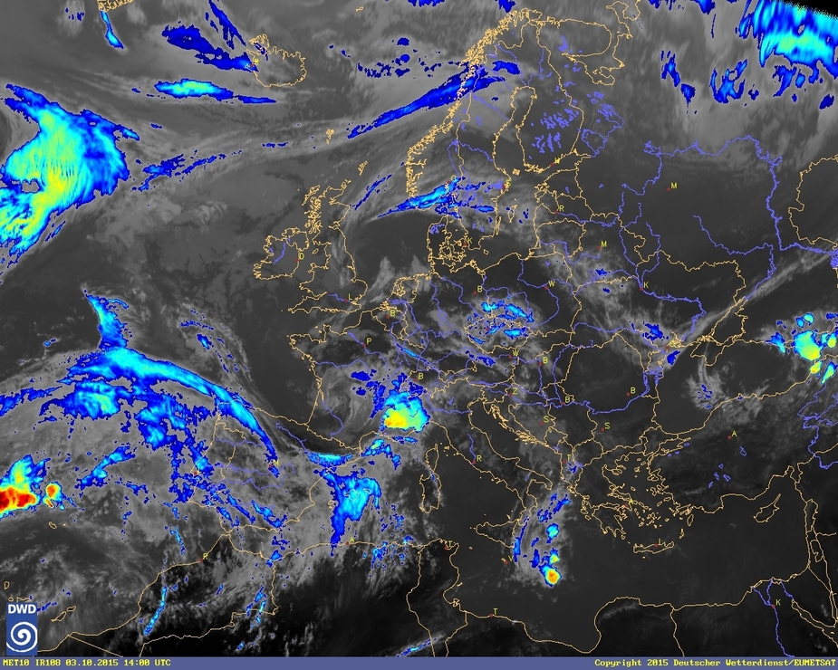
Why do you base your on-the-ground weather interpretation on a tool like ADL which is extremely condensed for in-flight satellite transmissions? Rather go for the original sources like the IR image to get an idea about the type of clouds.
I like more the color version!
achimha wrote:
Why do you base your on-the-ground weather interpretation on a tool like ADL which is extremely condensed for in-flight satellite transmissions? Rather go for the original sources like the IR image to get an idea about the type of clouds.
I want to understand better what the image tells me. I’m on the ground and can look up and see the actual situation. Being in flight I need to rely on the ADL and should understand what it shows. How the different colors relate to actual phenomena, etc.
As I was talking about departing and what I see from the ground I may have given a false impression of what I’m looking for. The two IR images (grey and color) need to be interpreted as well. I would have to ask the same question.
The other reason for my wish to understand this better is when I approach the area coming back. I noticed already that sometimes FEW is being reported but it turns out that it is in fact a BKN layer. On one occasion I talked to the Tower person and the answer was like “yeah, it does change and now it’s probably BKN”. That was 20 minutes after I landed with a METAR talking about FEW and almost would not have been able to descend through the clouds. It appears that the ground observation distributed as a METAR can be totally wrong and misleading. That’s odd and I would like to equip myself with more tools and knowledge how to use them properly.
But then I remember also that in a METAR nothing above 5000 AGL gets reported. As the mountains around here are quite high and so is the minimum altitude they let you descend IFR down to, you may end up still in the clouds and they won’t let you descend any further except you see the ground. The airfield is at less that 500’. So apparently METAR reporting stops at 5500 MSL. The minimum IFR altitude without seeing the ground at SLL (the VOR at the Sabadell airport) is 6000 MSL. I guess that’s why they always ask “do you see the ground”. All that means you cross over from France and descend somewhere around Girona to 8000 MSL (the lowest in that area) and expect to get under the clouds shortly after. But no, you are held up right in them and then cannot descend and land despite a METAR talking about FEW and nothing else.
In the case of the picture above, is there any way to guess how low the clouds in the blue area might be? The METAR is supposed to provide that information, but it might be wrong. Is there another way to, at least, make a reasonable guess?
in a METAR nothing above 5000 AGL gets reported
5000ft, or the MSA, whichever is higher. At some airports, possibly with automatic wx reporting, you get info to FL200 or so anyway.
I have a couple of writeups here (search for “tops”) which may be of interest.
The IR images need to be viewed together with sferics, MSLP, tafs and metars, and radar, to get a reasonable picture.
For low level wx, say below 5000ft, tafs and metars are the best guide, because the European wx offices all keep their 3D models commercially confidential, and GFS (which practically all free wx sources use) has poor data for such low level cloud depiction.