The reported lack of internet access prevents Webupdater doing anything.
I will have to revisit this matter if/when the 660 needs a firmware update 
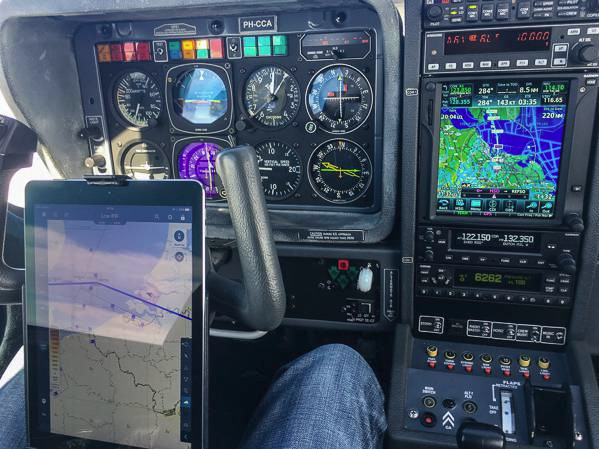
My next job is to dismantle the power + audio-out cable to create the connection to the aircraft, replacing the Garmin 496 connections.
Peter wrote:
I got exactly as far as above, but then (after pressing Next) it says there is no internet connection.
Could it be looking for a particular machine on the internet which is not available and then assumes the reason must be lack of an internet connection?
It returned that error message immediately, which doesn’t look like it is waiting for some server to respond.
The reason I did not persist trying to get Webupdater to work was because the 660 found the available database updates by itself (via its wifi) and offered to download them. It didn’t look like it needed a firmware upgrade for any of them.
I’m coming to this thread late, but here is my experience with my Garmin 795 which is yoke mounted and connected by bluetooth to a GDL39. The 795 is one generation behind Garmin’s 660. The 795 has no wifi connectivity, but it has bluetooth.
I use Webupdater on a Mac and it works seamlessly for my 795 and other Garmin kit that I own for other activities. I also use fly.garmin inside the Safari browser on the mac and that works well too.
The 795 is great for most things but it struggles with some controlled airspace for reasons that confuse and annoy me: when flying under the London TMA (i.e. below the 2,500 start of Class A airspace) time and again my 795 tells me that I am inside that controlled airspace. Why on earth does it do that? (I am one of those sad souls who keeps the whole system with all its databases up to date so it should work properly for all current airspace.)
I love Safetaxi. Very helpful indeed.
I used to have an audio feed from the 795 into the plane’s intercom, but when I went from Zaon XRX to Powerflarm for traffic warnings, the 795 became separated from my plane’s audio system because the Powerflarm connection harness to the 795 (for graphical depiction of traffic) simply doesn’t have as many wires as the old Zaon connection harness, and the audio from the 795 is no longer carried along the harness so can’t get to the intercom. I hate that, but there is nothing I can do. Powerflarm make the harness, not Garmin. (Thinks: perhaps I can connect the 795 to my bluetooth headset….hmmm. I’ll try that.)
The GDL39 provides a fantastic backup in case of a vacuum failure (as well as showing ADSB-in traffic, of which there is almost none in the UK.) When the GDL is connected by bluetooth to the 795, the AI on the 795 3D screen works very well indeed – a bit like having a Garmin G5 mounted on the yoke, but not certified of course.
I would love to sort out the false airspace warnings I get from the 795 and to get the audio to work again. The 795 is simply my favourite piece of kit in the cockpit in terms of situational awareness.
I have discovered that the Aera 660 will update its firmware over WIFI, and it works, so the Webupdater thing is not required at all, for anything.
There is some “unofficial” stuff on the net about loading custom georeferenced maps to these Garmin units, and Webupdater is then used to load them. This is kind of interesting, except that
I have had too many projects to do so will install the Aera during the “TKS Annual” in Jan/Feb
Interesting info @Howard . I looked at the 795 but it is too big for yoke mounting, without hitting something, usually my legs. This Dutch TB20 popped up for sale and shows the biggest piece of madness in terms of yoke mounted obstruction:
Clearly he (she?) flies only in a straight line and spreads the legs wide the rest of the time 
This is fun – just arrived on email:

They rolled out 3.10 a couple of weeks ago, so “interesting timing” to announce this well afterwards.
One more data point for this unit: battery life, screen 60% brightness, is 5hrs.
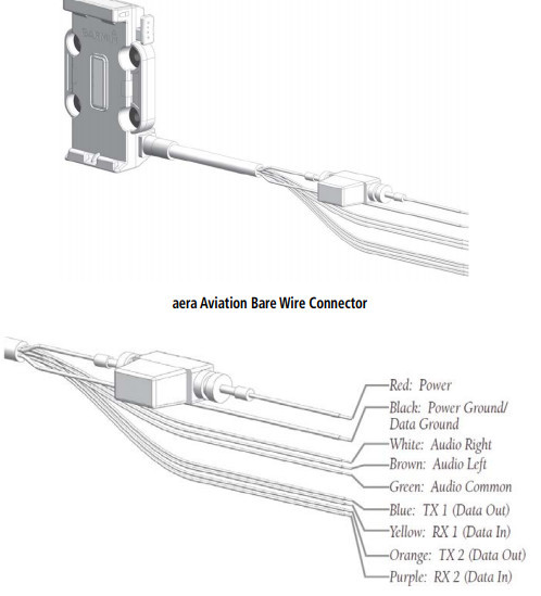
Being a rainy Saturday, I have just opened up the cable which came attached to the yoke mount (which terminates on a cigar lighter plug and a 3.5mm audio jack socket) and with a scope I determined that if you cut off those connectors, the wires you need to connect to are
thick black = gnd
thick red = +12V/+24V
brown = audio out ch1 (gnd=ref)
purple = audio out ch2 (gnd=ref)
yellow = unknown (has +2V on it)
orange = unknown
The last two were not terminated in the cable anyway. I tried configuring serial 1 and serial 2 for NMEA OUT and nothing came out of either of these two, so if you want data out you need to buy the proper 50 quid Garmin cable which has the lot
Current consumption is 0.4A at 14V and 0.2A at 28V, while charging and running the unit.
So, to get terrain and whatever other warnings, you just connect the two power wires and pick the audio off the brown one. It is around 500mV level. I think it is intended to drive a speaker, so there is plenty of power there – it isn’t a 600 ohm Zout output.
Yellow might be an input. The 660 has various options for TIS IN (US traffic data).
The two ch1 and ch2 audio outputs appear to output identical signals. They are identical on a scope at least. I don’t know if the 660 has any feature which would generate a stereo signal.
The 660 audio out differs from the 496 in that the latter appears to have a balanced output for a speaker, comprising of two wires. That is better because it avoids ground loops but I suspect Garmin had trouble with installers who grounded the other of the two outputs and blew the unit up
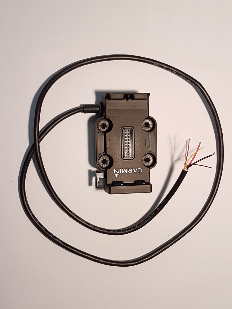
This is what you extract from the Garmin “Russian combine harvester” yoke mount which comes with the unit, after undoing the four screws and cutting off the above mentioned connectors:
I bought the Aero 660 from Peter Mundy here. Great service
Curiously, the Aera 660 user manual has just disappeared from the Garmin website… maybe they are re-organising it or maybe they dropped the product?