
At the OCA/H, a NPA has a margin to obstacles of at least 246 ft. The “undershoot” margin for a CAT I ILS (also taking into account altimeter errors of up to 93 ft) is 130 ft for CAT A aircraft and 142 ft for CAT B aircraft.
I see no reason why the expected undershoot when going missed from a CDFA should be larger that from an ILS approach. Since the resulting minimum obstacle clearance even for CAT B (246-142 = 104 ft) is clearly higher than what you can expect after going missed on an ILS, there should be no safety problems with using the MDA as derived DA without adding any extra margins.
Well, possibly in cold weather if you forget to adjust the MDA properly for low temperature, but even so you would need extremely low temperatures and/or an unusually high MDA to use up the remaining 104 ft.
Hence the question. I don’t believe IR examiners are aware of this more liberal interpretation, and not sure the original approach designers had this in mind.
It doesn’t take an electrical engineer to work out the NAV accuracy of an NBD DME approach, do you really want to be deciding at a CDFA ‘decision height’?
RobertL18C wrote:
However I read A1 above to still require a minimum height, unless the published approach procedure has a DH (A3 above), which presumably only applies to ILS and LPV with GBAS?
That is a rather strange way to read it. Paragraph (a) explicitly mentions “a non-precision approach (NPA) flown with the continuous descent final approach (CDFA) technique”.
(a)(1) just means that if e.g. the ILS has a notified limitation that it may not be used below 300 ft then your DH cannot be less than 300 ft. (a)(3) means that if a DH is published then your DH cannot be less than the published value. Typically, (a)(2) OCH or (a)(4) system minima will be limiting.
This is from the EASA Part NCO IR page 13.
NCO.OP.111 Aerodrome operating minima — NPA, APV, CAT I operations
(a) The decision height (DH) to be used for a non-precision approach (NPA) flown with the continuous descent final approach (CDFA) technique, approach procedure with vertical guidance (APV) or category I (CAT I) operation shall not be lower than the highest of:
(1) the minimum height to which the approach aid can be used without the required visual reference;
(2) the obstacle clearance height (OCH) for the category of aircraft;
(3) the published approach procedure DH where applicable;
(4) the system minimum specified in Table 1; or
(5) the minimum DH specified in the AFM or equivalent document, if stated.
(b) The minimum descent height (MDH) for an NPA operation flown without the CDFA technique shall not be lower than the highest of:
(1) the OCH for the category of aircraft;
(2) the system minimum specified in Table 1; or
(3) the minimum MDH specified in the AFM, if stated.
Currently on an LNAV or other NPA (non precision) you would look up at MDA plus 50 feet, or possibly more depending on inertia of the aircraft, so as not to penetrate the minimum descent altitude. I understand there is a school of thought that this new description will allow you to use the MDA as a decision altitude on an NPA if you have used a CDFA technique. However I read A1 above to still require a minimum height, unless the published approach procedure has a DH (A3 above), which presumably only applies to ILS and LPV with GBAS?
The exam limits for CDFA with DME are plus/minus 100 feet, and minus zero at MDA, at reference DME altitude. It might reasonably follow that a CDFA does not give you the required protection to treat an NPA MDA as a decision altitude?
In the same vein what are the requirements for an LPV to be flown to a DA in Europe? I am sure there is an answer in another thread but this seemed the most appropriate thread to repeat the question.
@AnthonyQ , not all countries allow SBAS (EGNOS) to be used for LNAV/VNAV. That’s the reason why I got LNAV/VNAV indication at EDDE Erfurt but not at ESTA Ängeholm. Yet, both show as LNAV/VNAV on the AIP plate. (Neither have LPV)
Germany is one of the few countries that explicitly allow EGNOS for LNAV/VNAV.
Thanks NCYankee…I’ll take your post as a “Yes” to my question in post #79! 
From a pilot’s perspective, LPV and LNAV/VNAV when using SBAS for the vertical guidance, are flown the same to a DA. The LNAV+V or LP+V appear identical to the pilot, but are flown to an MDA and the vertical guidance is advisory only. The TSO C146 navigators provide the exact same outputs to the HSI and autopilot for any of the approaches that provide vertical guidance, be it official or advisory. The LPV and LP procedures are based on SBAS. The LNAV/VNAV uses the same lateral guidance as LNAV and is designed to be used by aircraft that have Baro-VNAV for vertical guidance. The TSO C146 GPS is permitted to be used in lieu of the Baro VNAV for the vertical guidance on LNAV/VNAV approaches as accommodations limiting the FSD for the vertical CDI have been made. Of course if you are outside of the service volume of the SBAS, then these approaches may only be flown by aircraft with Baro-VNAV. The advisory +V vertical guidance for LNAV or LP procedures is an aid to descend to the MDA using a manufacturer constructed vertical path. In the US, this path is not a part of the procedure design and provides no obstacle protection below the MDA.
When the US was at its early stage of development equivalent to where Europe is now, most of the RNAV procedures available with vertical guidance were the existing LNAV/VNAV procedures and a few LPV procedures. As time went on, almost every runway that had an RNAV approach with LNAV/VNAV has had an LPV added, with the vast majority offering a lower DA. We are at the point now, where finding an approach with an LNAV/VNAV and not also having an LPV with lower DA is a rarity. I tell my students to ignore the LNAV/VNAV line of minimum as there will almost never be a case where it will be used with a WAAS GPS. I expect you will eventually get to the same situation in Europe.
LNAV/VNAV gives a glideslope. The autopilot shouldn’t see any difference between LPV, LNAV+V and LNAV/VNAV and happily fly all three glideslopes. (Maybe there could be some small difference how the autopilot navigates laterally on LPV vs LNAV+V and LNAV/VNAV. LPV becoming more sensitive as you come close to the threshold.)
This is going to be a dumb Q but what exactly does LNAV/VNAV give you, in terms of vertical navigation, autopilot coupling, etc?
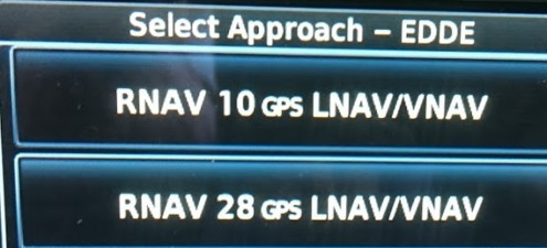
It isn’t LPV because no “GS” is shown on the Jepp chart (EDDE)
This is LPV (EGTE) where the converging dashed lines indicate LPV
and I know what +V is.
Finally. At the third attempt. RNAV approaches looks as expected.
At my the first attempt to look at RNAV approaches and what minima I would get, the aircraft was in the hangar with a Loss of Integrity warning that removed LNAV+V and LNAV/VNAV.
At my second attempt someone had disabled WAAS, EGNOS and MSAS. And even though I re-enabled them, I did not wait long enough for the GPS to pick-up EGNOS. (I only got 3D NAV) So, once again – no LNAV+V and no LNAV/VNAV.
At the third try.
I made sure that I had “3D DIFF NAV”.
I get LNAV+V at Roskilde EKRK.
And LNAV/VNAV at EDDE Erfurt.
And LNAV at Ängelholm ESTA. (ESTA has LNAV/VNAV minima but it is not approved for EGNOS glide slope only BARO-VNAV)
One conclusion is that I should have read the manual for the GTN 650.
One consequence of Loss of Integrity, LOI, is that LNAV+V and LNAV/VNAV is removed.
And “3D NAV” means that EGNOS has not been acquired and that LNAV+V and LNAV/VNAV will not show.
But from a user perspective I find the Garmin software implementation inconsistent.
If there is a LOI, why show LPV but not show LNAV+V and LNAV/VNAV. The argument is that LPV has been approved/tested and therefore WAAS and EGNOS is assumed to be working and that for LNAV+V and LNAV/VNAV the criteria are more dynamically checked. But I would find it more logical if LPV, LNAV+V and LNAV/VNAV were handled in the same way. After all, based on where an approach is located geographically, it is known whether it is inside the WAAS or EGNOS service area, so just by looking at a map you know if you can expect “3D DIFF NAV”. The GTN software could do the same.
And then I find the GPS signal names to be badly worded.
One could easily think that “3D NAV” is good enough to provide a glide slope. But it isn’t.
And “3D DIFF NAV” does not say outright that it uses SBAS. Only that the GPS is in “differential” mode.


