Peter wrote:
Interesting – thanks.
You are welcome. In editing csv or similar I am always jumping between regular expressions and spreadsheet tools. I agree that technically everything is possible, but not always sensible.
Peter wrote:
In this case I got a colleague to write a converter in C++ in about 2 hours which did exactly what I wanted, including subtracting 1 second from the label end time and adding the “,999” to it.
Well OpenOffice/LibreOffice does this if you use standard spreadsheet calculation (I am not 100% sure about the english function name, as they are translating them):
=B1-TIME(0;0;1)
If you want the ,999 just use
HH:MM:SS,999
as the cell formatting.
I guess Excel should do the same again.
Peter wrote:
(we did assume no flight will pass through midnight )
I know how these things start, once you have the whole process running and make great use of it, you want to use UTC and cross the Atlantic. ;-)
Going back to the moving map insert in a flying video, somebody has done it here using a rather roundabout process.
I am moving towards a view that playing back the Oziexplorer track (which I am sure happens accurately in real time) and running some sort of screen capture tool (to mp4, or to a long sequence of jpegs) will be the way to do it. Even capturing the whole PC desktop is OK because it’s trivial to pan/crop a track (Track Motion in Vegas).
There are loads of screen recorder programs – example
Peter wrote:
Going back to the moving map insert in a flying video, somebody has done it here using a rather roundabout process.
Is routeshoot any help for you? It looks like they are taking a log input and creating video with map side by side. Not sure if that is of use for selfproduction afterwards.
Peter wrote:
However, there is a subtle issue because one needs to do stuff in a specific order1) colour etc correction and lens correction and rotation
2) rendering any subtitlesotherwise the subtitles will get distorted
Why don’t you work with intermediates then? First create the finished video, export it in a high quality MP4 format, or even lossless if you like (if you have enough HD space). Then you can add titles later, in a separate project.
Peter wrote:
I’ve used Pinnacle (buggy crap), Adobe Premiere Elements (less buggy crap)
Have you tried this: Dashware http://www.dashware.net/
Telemetry Data Overlay on your Videos.
One of their video’s is from a guy in a Wingsuit, so the data must come from simple sources. Pretty cool!
First create the finished video, export it in a high quality MP4 format, or even lossless if you like (if you have enough HD space)
That’s what I do. Except Vegas has no “lossless” option. Well, not according to the various video forums where I asked. The best one can do is select 1080P 50FPS (to match the input format) and a really high bit rate e.g. 50mbits/sec (the camera is normally doing 25). On the LDLO video
that file was 100GB.
There is a number of “telemetry overlay” products out there. I think the automotive business uses that a lot, hence the “speedometer” presentations. Getting basic textual data is easy enough (once you know how, and have got somebody to write a GPS track to SRT or whatever converter) – example
A moving map is a bit harder but I think I have got it. I will just play back the Oziexplorer track log and capture the screen region to an mp4. Dashware (thanks for the link) does seem to have some sort of basic map here but it doesn’t look like it is a moving map.
Peter wrote:
Dashware
I found a much better product since called RaceRender. Dashware seems no longer supported and video did not work on Windows 10.
Peter wrote:
I am thinking of a movie in which the video frame has a section down (say) the RHS in which various textual data is displayed, and this data comes from a text file which is in (say) CSV format, with the first column being the date/time.
RaceRender will do exactly that. And it’s basic version is free. I’ve played around a bit using data logged on my iPhone through their TrackAddict app (which is also free), logging lat/long, speed, heading, G-force multi-axis, elevation etc. Looking forward to try it on my next flight.
By the way, if your video needs more processing after you’ve added the gauges, a trick is to use a Blue background behind the gauges and then Chroma Key the blue in your video editor app replacing it with the processed video.
You are right that a moving map isn’t supported, however it will be possible to add a still map image behind your track. Would be nice if they added some OpenSource maps.
I have just installed MOVAVI. It works brilliantly. 23 quid well spent.
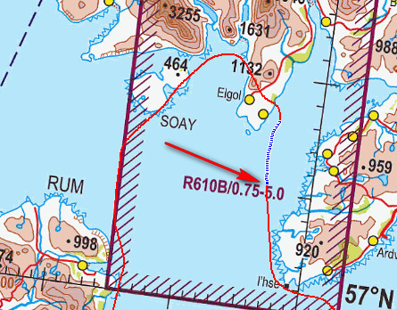
Getting Ozi to continuously scroll the map (as one gets when running it as a GPS moving map) is more tricky… currently it scrolls it only when the plane reaches the edge.
I will need to use a different map playback method, having converted the Ozi track to KML or whatever.
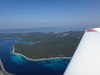
The best Ozi can do is this
What I need is something which displays an always-centred moving map, with an “aircraft” symbol in the middle, pointing the right way, when it is fed a GPS track. It should be possible with Google Earth.
There is a further issue: Oziexplorer doesn’t log the track points in equal time. It has options only for equal distance, say every 100m. This scuppers this whole method of playing back the Ozi GPS track. I need to get a GPS app which logs every X seconds, accurately. Probably, will look for something to run on the phone…
Peter wrote:
I need to get a GPS app which logs every X seconds, accurately.
I highly recommend OSMAnd+ for android.
Offline Maps means they are alway available everywhere you go, with or without an internet connection.
Also, the offline driving directions are a little dicey, but work great in 3rd world countries where internet access isn’t always available (or in the mountains in some areas that are too remote for cell service).
I log most of my airline flights with this, so I have a pretty cool “trail” all over the place. It also helps to keep my personal flights separated from my commercial ones (SD for personal).
In some places where SD lacks ground detail, OSMAnd is great because it shows the entire civilian network. I’ve had to use it more than once when SD acted up, and I wanted to be precise about where I was flying (VFR, of course).
That’s neat but isn’t so good on a raster map 
I have this app for GPS track logging. It logs KML, GPX and NMEA all concurrently. I am just testing it to see if it is accurate in time (no cumulative errors) which is obviously necessary if it is to be dropped onto a movie timeline.
IMHO, for a movie inset moving map, one needs north-up, and a plane symbol which points according to the instantaneous track.
The track playback needs to be done on a PC, into an mp4 file. That bit I have working really well now.