Neal wrote:
But you can hear it.
Maybe, but the “eyewitness” said he saw fireballs….
Gigicret wrote:
Flying in the Rhone Valley can be destabilizing for someone who is not used to it …Definitely, I can confirm that! Landed once at Raron during strong Föhn winds in the afternoon. That was quite challenging, despite my preparations. Especially due to the narrow valley at Visp, which results in even more stronger winds. Another time, I experienced also heavy turbulences at Martigny, where several valleys come together, plus the classical valley winds and warm/cold air flows. Not a joke if you didn’t flew with an experienced pilot or instructor in the mountains before. There are definitely easier valleys in the Alps to collect first mountain experiences.
I can not confirm that at 6000 feet Brig, we can receive it. In any case, in Sion at 6’000 ft impossible to get in touch with GVA info 126.35Good to know, never tried that below 8.000 ft in the Rhone valley. Above 8.000 ft, Geneva Information is really good reachable east of the Pfynforrest.
Maybe helpful when starting to look at possible routes: The Swiss ICAO-map (available online at no cost) shows minimum altitudes along the “recommended” / “usual” pass routes…Some of those minimum altitudes are also shown by Skydemon, but not on all routes. They display it on the Gemmipass (unfortunately, not in each zoomed perspective), but not on the Simplon. I will send an e-mail to them.
No relation to the accident …
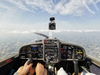
This photo was taken by a friend pilot at the Sanetsch Pass on 28.07.2018
1 day after the loss of a friend pilot of our club of Sion at the Durand Pass (27.07.2018)
A few days before the death of Reto Aeschilmann (Pilatus chief test pilot) and his family, at Rengg Pass. (04.08.2018)
Just days before the JU-AIR crash (04.08.2018)
Less than a year after a crash at this location (20.08.2017)
All these accidents happened with perfect weather and visibility!
He had an incredible chance!
He turned around, passing 50 meters from the ground (160ft)
Then he was able to climb again and pass the pass.
On board it was a Swiss instructor, with his pupil !
no other comments…
To add a small bit to this tragedy. I was driving past Lausanne at approximately the departure time and saw a PA28 departing north from the airfield. I suspect it was G-BVDH as the timings are just about right. I’d left the Val d’Anniviers and driven past Sion earlier and the weather was benign with blue skies. When I fly from Sion to the UK I can’t contact Geneva from the area of Bex if I’m lower than around 7,000 feet so there’s virtually no chance that he’d been in contact with them after Sion. Regarding the witness seeing two fireballs and then a bang after a few minutes, the time difference will be down to the significant speed difference of sound and light. A very tragic outcome and my condolences to family and friends.
Bloody hell indeed… This just proves what most of us knew already: no country in Europe has a monopoly on pilots doing crazy things, or crazy instructors.
… probably anywhere in the world 
gallois wrote:
I will stick to crossing the alps at a minimum of 2000ft above the highest point on my route
That the MSA definition 8km near mountains/terrains that are higher than 5000ft 
Does not help if you are mistaken about how high the highest point on the route or in its vicinity actually is, which is (together with “missing” a planned climb en-route) IMO the most likely reason for this accident.
The reported height of mountain peaks are highly reliable and obvious (anything with a name on it will be at FL100) and can feed straight into your own min height calculations
The MSA calculation is a bit route specific but +2000ft is still a good margin if you confuse the top of a valley and its saddle point or if the map elevation data is crap (less the case of Switzerland but this business as usual somewhere else ), still nothing prevents you from reading the valley saddle point ground elevation as your MSA?