Peter wrote:
The challenge is to download the map tiles from these sites and combine them into a single graphic file, so it can be run offline, as a GPS moving map. You may safely assume it has been done but not by anybody who posted about it on EuroGA
We have probably all tried that already and unfortunately there is no viable solution. But we can keep on dreaming but at least Openflightmaps seems to go the right direction and might get where openstreetmap is, which has even overrun Google maps in some features. I don’t like to fiddle around with the ICAO Map Viewer as it has too many useless options for me. But having all of Europe’s maps stored in PDF or JPEG format is technology of yesterday and I believe raster charts are the way to go.
We have probably all tried that already and unfortunately there is no viable solution
It’s been done but isn’t discussed openly as to where you can find the maps.
I don’t doubt it is legal to download for your own use blah blah blah… after all it is on an open website and if you had a huge monitor you could display the whole map and press PrtSc 
What is less legal is generating whole maps from other stuff, but that goes on too. Anything that can be displayed on a screen can be captured and joined up.
Then one has to georeference it. This is where you find a rather limited range of apps, if you want to handle aviation maps in Lambert Conformal Conical projection. Only Oziexplorer can do it (windows and android only) AFAIK. But the public online maps are Mercator (rectangular projection) so they could be run under a range of apps including some IOS ones I recall somebody messing about with.
But we can keep on dreaming but at least Openflightmaps seems to go the right direction and might get where openstreetmap is, which has even overrun Google maps in some features
It’s never going to happen in aviation. The data changes too fast and there is the “liability”. Also OSM has a lot of emotion/motivation behind it, to screw the stranglehold of terrestrial map providers, and Google.
I believe raster charts are the way to go.
I think you mean vector charts. All the maps in existence today are done in CAD and thus exist as vector data. They are not released as such, IMHO mainly for anti piracy reasons. But also it is much easier to debug a raster display client (Oziexplorer, Memory Map, etc etc) than a vector display client which has to deal with loads of objects such as text labels and also dynamically declutter according to rotation (Jeppview, MFDVFR, etc).
Peter wrote:
I think you mean vector charts.
Yes you are right. My mistake.
Peter wrote:
It’s never going to happen in aviation. The data changes too fast and there is the “liability”.
And we are far less populated community than the OSM mappers. But can Jeppesen be and stay the only provider of somewhat confidential charts covering the world?
But can Jeppesen be and stay the only provider of somewhat confidential charts covering the world?
That discussion is the world’s second oldest profession
All the time they have 10k-20k commercial customers each paying some 5k/year, the answer is YES. Nobody will want to take on the massive task of generating approach plates from the national AIP charts.
For VFR enroute charts there are other options but again the current tablet apps seem to have the market sewn up pretty well. What keeps that business going is the lack of machine readable national charts. The charts mentioned in this threa are all raster charts and no tablet software provider can just read them in and generate a vector representation which (with stuff like auto declutter) is the current fashion for tablet software. Jepp are not involved in this business except via the MFDVFR app.
Vladimir wrote:
ermany, Austria, Switzerland and new maybe even Czech Republic here (login required, then go to Flugvorbereitung → VFReBULLETIN and check ICAO at the top right).
MedEwok wrote:
Wow thank you for that. I have an AIS account for DFS and use it for flight planning but never realized you can see the ICAO charts there also.
Can you get a DFS account even if you are not a German resident/have a license issued by the LBA?
Airborne_Again wrote:
Can you get a DFS account even if you are not a German resident/have a license issued by the LBA?
Sure. All you need is fill in a registration form. I did it yesterday.
Now, the question to DFS VFReBULLETIN users: can you only view the charts online, or is there a trick to export them (other than making multiple screenshots)?
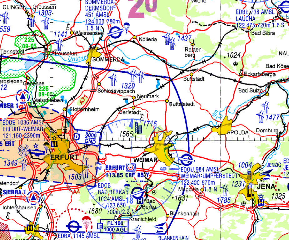
Is this the DFS chart? It has heavy (deliberate) jpeg compression artefacts