if your software map does not have a city and you are asked to do something abeam it, how would you react? Ask ATC for another landmark?
ATC are not supposed to require traffic to fly via VRPs (visual reporting points) unless they appear on the ICAO VFR charts.
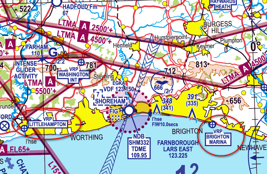
UK style:
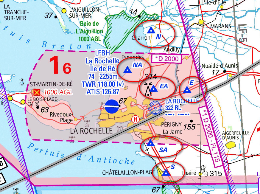
Jeppesen (2013) style:
We did this here
I will never forget the La Rochelle ATCO yelling at me to report at “Silver Point”, which was probably “Sierra Point” i.e. the one to the south of the airport which by convention is marked “S” i.e. called “Sierra” but that guy didn’t know the aviation English for “S” is “Sierra”… the locals based there who I spoke to afterwards heard the exchange and didn’t understand it either…
Actually, a visiting pilot often has no chance of finding the official VRP either, which is why this can be a real issue when flying VFR. The solution I have always used was a moving map GPS which shows the VRPs. A couple of years ago I checked all the Garmins in a local pilot shop and they all showed them.
The solution is a moving map GPS for VFR, and an IR for everything else  But even if you file IFR, if you have to go to an airport which is VFR-only, you still need to potentially be able to instantly find the VRPs.
achimha wrote:
ATC feel most comfortable with waypoints
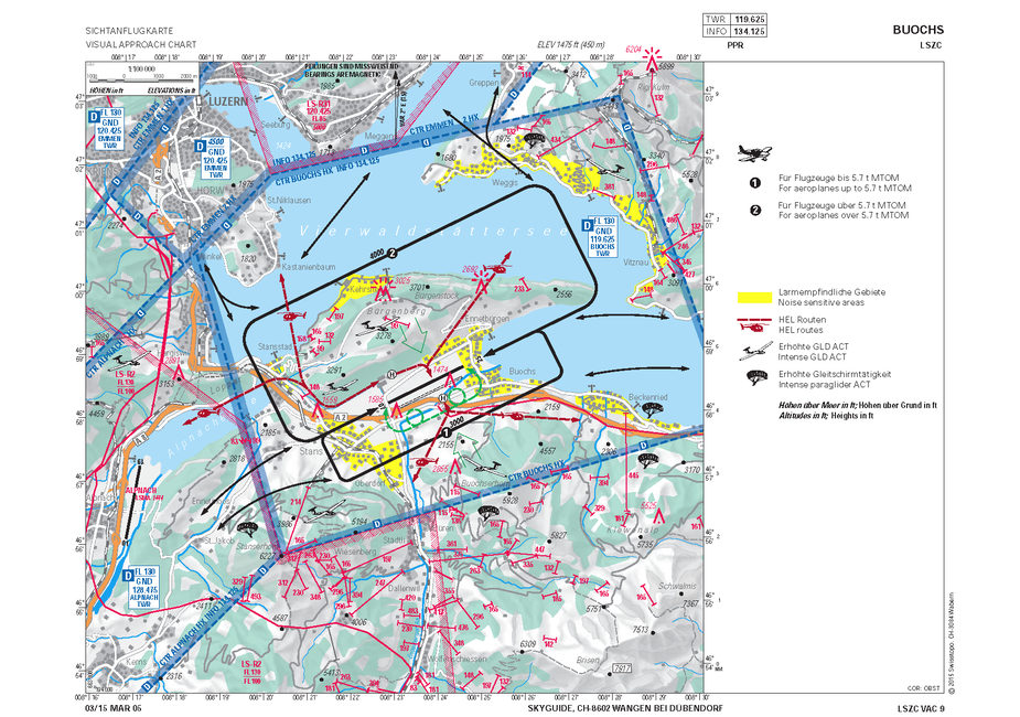
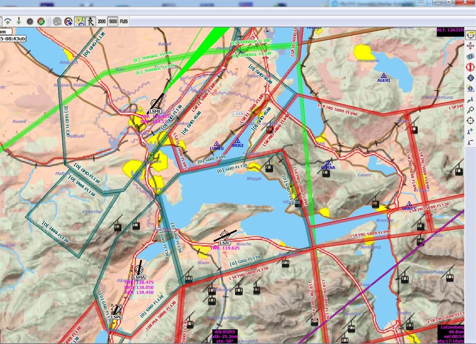
I can see your point but is it practically possible in all cases? Have a look at the official chart of Buochs – it is a takeoff, no waypoints. My clearance was “Cleared for takeoff runway 25 with right turn out, report abeam Weggis”.
By the way I’ve never heard anyone flying VFR in Switzerland quoting IFR waypoints by the way, neither ATC nor pilots, although I now know people do it.
Vladimir wrote:
My clearance was “Cleared for takeoff runway 25 with right turn out, report abeam Weggis”.
“Unfamiliar with the area, don’t know Weggis.” I really don’t have time to comb through maps, when VFR you have to see and avoid. ATC will figure something else. In this case they would say “report when on the north shore of the lake” and all is fine.
In this case Weggis is on the official AIP map which I would of course have flying there and it is just at the exit point of the traffic pattern so of course I would be able to comply with “report Weggis”. It’s hard to overlook…
By the way I’ve never heard anyone flying VFR in Switzerland quoting IFR waypoints by the way, neither ATC nor pilots, although I now know people do it.
It tends to work in the UK if the pilot uses it (and I often do, because it can dramatically abbreviate a CAS crossing request) and you are speaking to a radar controller (who will know where they are located).
I have found that elsewhere in Europe, if flying VFR, and you refer to the five-letter IFR waypoints, ATC will usually ignore the radio call… they are entitled to do that.
As I keep saying, if you get an IR and use it, 90% of this crap just falls away 
Airborne_Again wrote:
In fact SkyDemon also includes the airfield Skogn (between Frosta and Henning) which is not on the EasyVFR chart!
Hmm, that is both impressive and a bit scary. Skogn is hardly an airfield. More like an extension of the lawn of the farm building. Up until recently you could only land and take off in the same direction. If you landed just a tad long and hesitated a fraction of a second, you would end up flying straight into the farm building at the end of the runway. Today the runway is moved to the east and some buildings have been re-organized as well together with power lines. Since when did Skogn come on the map? The airfield has been there (in several improved versions) for some 20 years.
achimha wrote:
Anyway, my obligations to AFIS are very limited.
Yes, but that is not the point. The AFIS is there for information purposes, but the airfields are still used by commercial regular traffic, and they fly IFR with no clue as to where you are unless someone tells them. It is in everybody’s interest that traffic is done safe and efficient, and it is the pilots responsibility that it happens (all the pilots). Flying there without a proper map so you can communicate your position is not very responsible.
AFIS airports do not as a rule have VFR waypoints.
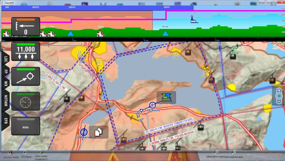
Easy VFR
Pocket FMS (Desktop).
Weggis is a reporting point for Buochs and it is on the Approach Chart. So yes, they are absolutely correct requiring you to know where it is. Apart, whoever lives in Switzerland must have come across that particular place :)
In fact, I remember FIS telling me they do NOT have all the IFR waypoints on their screen but a large number of city names. I’ve had them query me once or twice when I reported my position as an IFR waypoint or stating I was going towards one. That surprised me too. I try to fly via IFR waypoints for the very convenience that I can use them in the GNS430W as well, which in turn drives my autopilot :)
Easy VFR has quite a lot of detail, lots of town names. Pocket FMS (desktop, I never used it on a portable) is a bit more detailed at first glauce, but I believe they have the same database.
Frankly, I prefer the map of PocketFMS for flying and sometimes print out some segments of it as a reference.
I wonder why i keep hearing so many things about Ipads going bad. Never had a problem with any of my Samsung Tabs.
Mooney_Driver wrote:
Weggis is a reporting point for Buochs and it is on the Approach Chart.
I beg to disagree. Weggis is on the approach chart but is not shown as an official VRP. Neither is it listed as a VRP in the Swiss VFR Guide. It is simply a village/town shown on the map. The VFR guide lists no VRPs for Buochs
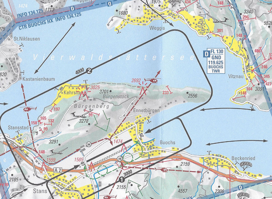
You are right Peter. It is not an official point.
However it is quite well known as a village, there is even a song named after Weggis. So most Swiss pilots would know the place even due to that. And of course it is quite visible on the approach chart.
EVFR has the village and it is selectable as a point in a flight plan.
reporting VFR is always tricky. In general, only villages/town/other points from the ICAO 500 000 chart should be used (apart from VAC points) but the number of local variations is very high. Noise is also inserted by local pilots knowing all the small suburbs by slang names and ATC/AFIS playing the game. The stranges is simply lost.
There is no point in trying to capture the variatio or to argue. Simply ask them for guidance or fly IFR ;-)