Silvaire wrote:
For the cost of the upgrade from Pro Plus to Performance Plus, I’ll continue to use Google Earth for airport 3D viewing – I’ve been doing that for years.
Exactly, same here.
@Josh_Tahmasebi_ForeFlight wrote:
Just an update that ForeFlight 11 was released today so I’ll share the release notes here:
Hi Josh,
let me quickly comment on the new release:
Airport 3D View > a pity you spent money developing it, my view . totally superfluous . but nice to see you put it in the list to people paying extra for it! ; Breadcrumbs > in principal nice, but a permanent trail may not be the best choice, have to check it in flight, I usually prefer a 5 minutes back trail in flight, complete trails are for ground work, not flying, my 2 cents opinion; Expanded Coverage > Yes, that is very welcomed and it is nice to see progress there, hope Poland and UK are soon available too (with graphical NOTAM just behind of course); KMZ File Support > adding a zip function to the .kml file handling, hm, anybody need that? ; Settings Filter > ok, we’ll see, may be handy with the long list; Social Channels > if it is an add on for those addicted to it fine, just keep in mind there are loads of pilots not using social media at all
As we talk now a request for change. If you long-tip on the map, it shows this nice Add to Route selection. Unfortunately if you hit Airports, Nav or Waypoints it won’t show these on top of the list, as I would expect it, but have to scroll down – always. Would be nice to see this changed into the selected items on top of the list. Thx for forwarding to the development.
It also would be nice to have all VFR charts under one selection. Yes, I do understand you want to keep the pay2fly DFS charts away from the rest of the world, but for cross border VFR a seamless navigation would increase safety, especially since you decided to not make obvious the selection in the top left field, both say ‘Aero & VFR’ if both selected: 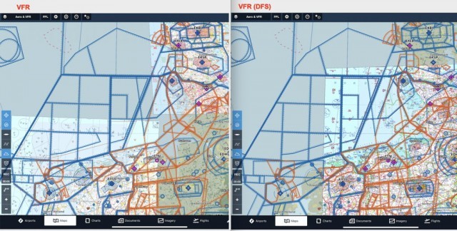
Hi @Silvaire, @172driver, @dejwu,
I will take all the feedback back to the team.
@172driver – not at this time, but I will make sure this gets the right team.
@dejwu – Appreciate the comments on the release. Yes Poland and the U.K. are on the list to come as well as additional features like Graphical NOTAMs. I’ll make sure to note your feedback on the Add to Route view and VFR Charts. On VFR charts there is the potential for some of these to get a bit tricky since there are both included and add-ons for the same country. I will do some thinking on this one.
Thanks again.
Josh
Hi Josh,
it’s really awesome to see you guys iterating and improving the product so quickly. I’m more or less tied to Garmin Pilot, a vastly inferior product, because of the Database Concierge feature which is excellent. Is it something that Garmin would realistically let you guys have at some point?
Hi @Denopa,
I don’t have an answer for you on this one. I will pass it up the chain to the team here that works with Garmin though.
Josh
dejwu wrote:
Airport 3D View > a pity you spent money developing it, my view . totally superfluous . but nice to see you put it in the list to people paying extra for it! ; Breadcrumbs > in principal nice, but a permanent trail may not be the best choice, have to check it in flight, I usually prefer a 5 minutes back trail in flight, complete trails are for ground work, not flying
I’d say the exact opposite. Wouldn’t know what to do with ‘breadcrumbs’ (what’s that supposed to be good for ???), but going into challenging, unfamiliar fields (mountains, etc), the 3D preview is great. As noted earlier, I use Google Earth and X-Plane for that and will, alas, continue to do so.
Hi Josh
I really like the pace things are moving forward with FF however I feel like that the priorities are on the wrong features. 3D preview, breadcrumbs, etc. for me are “nice to have” features but graphical NOTAMs, decluttering, flyby waypoints, etc. are much more essential. I generally feel like that at the moment we (Europeans) are getting much less for our money, for example the logbook is not really usable since it is very much FAA tailored, imagery for the USA is much more advanced, etc. you get the point.
Jonas
Just an observation. Different teams work on different features, so just because a particular feature is released first, it does not necessarily follow that delays the work on other features, because the teams generally work independently on the areas they specialize in. In other words, those that work on logbook are not going to affect the team that works on filing, and so on. On the other hand, In cases such as flyby waypoints, multiple teams may be involved and the work of some of these teams such as performance, routing, and filing have dependencies on one another, and long before the final product feature is released, the infrastructure has to be added, so you don’t see the progress that is being made until the full feature capability is released. Progress is being made on many of the items discussed, but until they are available, it may seem as if nothing is being done on them or that the focus is elsewhere, but this is far from the truth.
Another thing to consider is the release velocity of ForeFlight. It is almost monthly and many of the projects getting released have been many months and in some instances a year or more in the making. ForeFlight used to release on a schedule that was more closely tied to major updates. Currently the product updates are more periodic (monthly) and what is ready to release is released closer to it being completed, QA’d and beta tested. A quick review of recent major releases since version 10 in April of 2018, 10.1 was released in June, 10.2 in July, 10.3 in August, 10.4 in October, 10.5 in November, 10.6 in December, and in the first week of February 2019 version 11.
After experimenting with GarminPilot for almost a year I’m using ForeFlight for several months now and personally find it more user-friendly than GP.
I like the ongoing new developments and feel that FF is really making an effort to invest in the program for European pilots.
For my VFR flights, I still prefer Jeppesen Mobile FliteDeck VFR though. The main reason for that is the Graphical Notams on the map and the great way the airspace information (including radio frequencies) is presented by a pop-up menu. If FF adds this as well I see no reason any more to use separate tools for IFR and VFR.
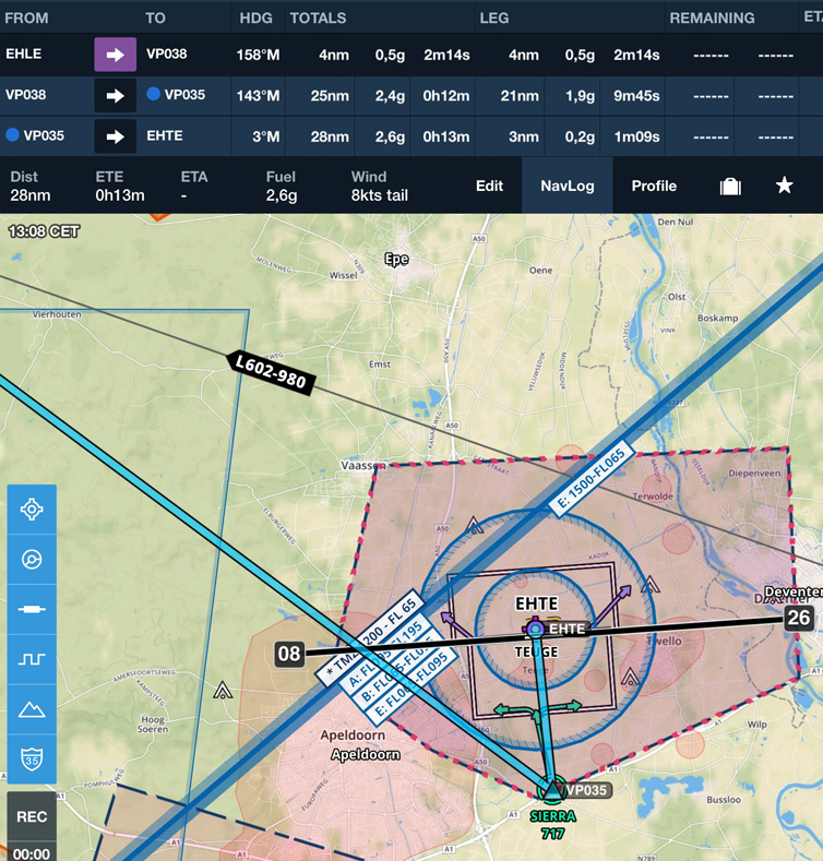
I wish FF would make VRPs useable. In this example the VRP is correctly labelled on the chart but on being selected for a route it gains another identifier and it is the second identifier which is used in the navlog. Here VRP Bravo at EHLE becomes VP038 and VRP Sierra at EHTE becomes VP035.
Until this is resolved I feel FF is not usable for VFR flight. Perhaps one of the many FF Teams can fix this.