
I often use skyvector.com for rough planning, the DWD account on flugwetter.de for met briefing. Depending on the weather, I look at the reports, METAR/TAF, Meteograms, Low Level SWCs, Cross Sections, sometimes SkyView, very seldom GAFOR and if its marginal, I look at the radar pictures and give the Met Office a call for a weather briefing. I check Notams with the DFS AIS site. If we have severe CAVOK, this routine takes about 5 Minutes, in marginal weather this can take its time, though.
Then I do my flight planning on the paper charts and a plog, although I seldom use the plog itself. I wite courses, distances and times (estimated) on the charts.
If I have a panel mounted GPS, it's usually of the useability of a Garmin 100 or something like that, so it gets the destination tuned in.
Then I tend to use the FLY IS FUN App on my Galaxy for GPS support. It has a nice HSI page and some sort of GPS based ground proximity warning, with is more than enough if you stay in VMC conditions, and can help keep up situational awareness, when encoutering personal weather minima.
My father just bought skydemon, but I haven't tested it, yet.
For most such flights, I check weather and NOTAMS, and check again in the cockpit before booking out. I carry a chart, and a Garmin Etrex with user waypoints, but seldom use either. I have a kneeboard sheet with previously measured tracks/distances on one side and radio freqencies on the other. On booking out, I give a longer duration than expected, then fly to avoid shower activity, below cloud and usually below the summits, which are often in cloud. For flights into unfamiliar areas, I enter the route in the Etrex, and use a chart with marked lines. I always use the Etrex for difficult-to-find fields, unless very familiar with them. (I've done an approach, with a late go-around, to a strip of cabbages, runway shape and length, and parallel to the field with the runway) My aircraft has no A/H, DI, nor VOR. Course on compas only.
...back in 2008 I purchased Quick plan-which was old even that time. But still the most straightforward way to have a quick overview of route to be flown. And print navlog - if not left in printer or at home together with GPS (a la Dar pilot). Tablet with pocketfms or skydemon is nice and handy, but much slower... Generally up to an hour away from my base it's local knowledge backed with A3 color copy of current chart somewhere on the floor. The folded original chart in the bag just for the case.Luckily enough only limited number of restricted areas around. Notams by aisview - graphical display of notam by our kind ANSP.
Longer routes primarily with panel mount GPS backed with paper map and tablet. Order of primary and secondary nav device might be case by case, place by place.
About fuel calculation - unless EET is somewhere60%+ of endurance (actual endurance, not the published one) or an really isolated destination I do not care too much. When above treshold quickkplan used to calculate 10-15 kts headwind to get an idea. For VFR I do not care about profile and various fuel flow, for IFR at FL100 I should be doing a better job...
MSA- I am strict on this for night. It would be great to stick to MSA in marginal VFR, but when it came to scud running, you can't follow MSA. During CAVOK there is no reason to care about MSA and I doubt IAm the only such careless pilot on earth
Look at map, decide optimum route , ideally straight line so its a choice of go through or avoid airspace. Draw wind on chart, eyeball heading, use thumb to measure time. Calculate fuel, navaids that may be of use and who to talk to. Fly track using 6 minute fix points. Equipment required:
Map
Protractor
Felt tip
Met forecast
Notams
Knee pad
[edited for text formatting - see here]
how many of you guys are using fix points on map mentioned by Tumbleweed ? I was somehow using them years ago, now it´s replaced quick checks of ETA calculated by GPS....
I've restrained myself (no kidding  ) from commenting, because Cookie is trying to do a survey of nav methods.
But I do think that one can get away with a lot of stuff if one
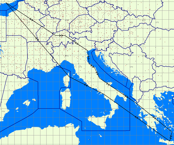
If you are trying to do a long trip (example of one of my first long post-PPL trips) then the "old" methods are going to make a lot of work. Even 11 years post-PPL, I would simply give up flying if I had to use visual nav and nothing else. It would be too much hard work. GPS has transformed the enjoyment of going to places.
Lines on chart using recognisable features as turnpoints, flight planning on Skydemon, weather info from the met office.
If the area is new to me check turnpoints on Goggle earth and use Easy GPS to transfer flight plan to simple Garmin 96 GPS which, when in use, normaly hangs on my straps for a quick cross check.
It works well for me, but I do fly very slowly
how many of you guys are using fix points on map mentioned by Tumbleweed ? I was somehow using them years ago, now it´s replaced quick checks of ETA calculated by GPS....
Rarely. I think the last time I did, there was a NOTAM'd GPS Jamming exercise, so I thought it prudent to mark where I have been. However, I think if I was lost, sitting there looking at the map where I was 10 minutes ago I wouldn't consider a huge amount of help. I would either identify where I was based on what I could see right now, or if I was really unsure I'd call 121.5 for a position fix. Hasn't happened yet, but I cant say it wont.
Cookie, I use GPS primilarily. There is another GPS for back up and I also tune the VOR/DMEs as well.
Nobody should fly long distances to unfamiliar places by just looking out of the window and using nothing else.
How many airspace busts were due to mis-identification of visual features?
Skydemon for planning and flight here on an Ipad3, backed up by Skydemon on a HTC One. Autopilot flies off the certified GTN750 - abandoned paper charts. Airfield charts in JeppFD
Considering PowerFlarm Core for traffic on Skydemon


