
Considering PowerFlarm Core for traffic on Skydemon
Me too, then I can get rid of my little Zaon Mrx and the NATS aware unit (which I have already stopped using) and have everything integrated in the iPad. My only qualms are having total reliability on devices running through the iPad (and the power they demand), and whether to get the portable or the core version of the device. I think I'd like to see it all in action (not just on a YouTube clip) and hear some reviews from people. There probably are some if I looked a bit harder :-)
Check weather via
Aeroweather Sat24 Orbifly And maybe ogimet .. But usually not for a 1 hour flight
Notams via Notams HD
Route will be by memory and gps or by echart.. The only really complicated piece is the belgium airspace south of EHEH. Skydemon and Skymap electronic charts .. Backupped by a paperchart.
W&b by knowing your configuration.
Just before takeoff load the latest skydemon information .. And dowload the latest weather in sky-map.
Jeppfd for the airfields
VFR Half mil with route marked showing track/distance - use clock code for heading Met office for Wx - metars, 214/215, rainfall Notam map for UK Garmin 196 back up
IFR Plog/low level airways chart Met office or Austrocontrol - SigWx chart Austrocontrol for Notams Program relevant BRNAV
Even areas I know well can look quite different depending on season/light/time of day, and flying VFR in the SE UK I try and discipline myself to flying a planned/calculated heading with a line drawn on the map.
Thanks everyone for your responses. It is much appreciated, and will hopefully help to shape future training and testing.
Cookie
For areas I'm familiar with - check NOTAMs on skydemon, take off, look out the window.
For longer trips, plan flight with Skydemon and also draw a line on a paper chart, and fly with Skydemon running. My ancient aircraft has no navigation instruments apart from the wet compass and equally ancient WWII-era directional gyro, so if Skydemon should fail it's back to pure dead reckoning and pilotage.
(Old fashioned VFR navigation shouldn't be something to be afraid of - when I owned the Cessna 140 in the US, I flew coast-to-coast using a map, timer, and looking out the window. However I prefer to have Skydemon available in Britain since the airspace is such a mess, especially in the south of England where the chart clutter can mean it's too easy to miss some odd irregular airspace polygon that could wreck your whole day).
Check weather radar..if a flying day, plan in SD and print plog. Keep official chart with me and look at waypoints out of curiosity. Usually play with VOR or DME for something to do during flight.
So here's my million dollar question: since the CAA/EASA are kicking and screaming to technology out of the cockpit (think how long it took to remove IFR screens), if we were asked by an examiner in a skills test how we navigate, how many could tell the truth? It must be tempting to tell them about slider rule, protractors and pencil sharpeners...
DMEarc
if we were asked by an examiner in a skills test how we navigate, how many could tell the truth? It must be tempting to tell them about slider rule, protractors and pencil sharpeners...
I don't know why one would bother. The examiner (that you are having a casual conversation with, outside any test scenario) cannot ground you even if you told him/her you navigate with a rubber duck floating in a bucket of water (the duck gives you the heading to fly).
At the debriefing after my initial JAA IR test I happily told the examiner I fly 100% on GPS, with VOR/DME as a backup. I think most of the real experienced geezers have nothing to prove anymore and are actually very realistic. It's the ones who never fly anywhere who still think the old slide rule etc is the correct way. Unfortunately the CAA initial IR test has a specific syllabus and you could get a load of NDB holds and an NDB approach, so you do need to train them.
This is how I navigate ;-)
Today on a short hop from Landshut to Straubing …
That’s SkyDemon on the iPad mini
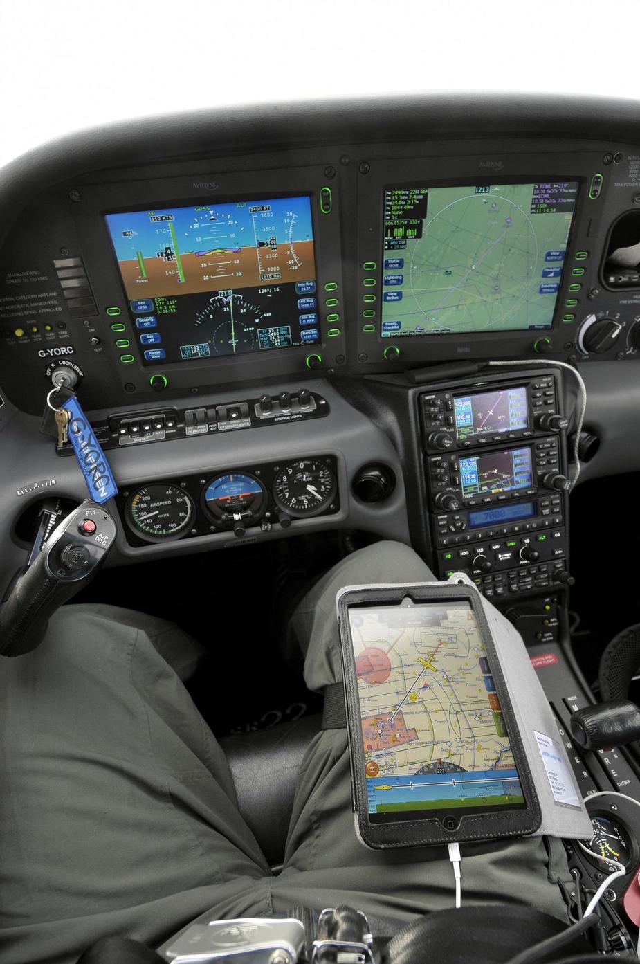
Alexis, how come you run SD as well as the Avidyne and Garmin 430s? Not a criticism, just interested – as a backup?
No matter how I navigate, I need my displays in "Track Up” mode. Four charts around me all showing my aircraft going top right corner to bottom left corner would get me lost within two minutes…


