
That’s why the Jepp plates have the morse dots & dashes on them.
knowledge of Morse code isn’t actually required in the syllabus any more
You don’t need to know morse and I haven’t done it since 1969 when I was a radio ham – OK1OFA 
It is printed on the charts
But you’re missing the point about human factors….we are fallible…we take shortcuts….we screw up….
RobertL18C wrote:
I would NOT fly a LOC/DME approach unless all step-down fixes are in the database.
There are a fair number of such approaches in the US. Most ILS in my GNS530W database for ILS with a localizer/DME option do not include stepdown fixes inside the FAF. If you are tied to the concept that you can’t fly a ground based approach that is not in a database, that is very limiting.
Ortac.
I disagree on a GPS you are offered two Stations with the ident XX and you choose one, is it the right one and how do you check you have got it correct ?
With a DME you tune the unit to the correct frequency and the check the ident the ground station is putting out…….if you have the correct ident it has to be the correct station because two DME stations with the same ident will not be located in radio range of each other.
Very little room for error with DME but one rash slip of the finger with the GPS and you have an error that is unlikely to be picked up in a high workload situation.
A_and_C wrote:
There is not currently any training in Europe for this being it is not approved, so pilots like you are making your own procedures
Just to be clear, in the US, there is not any specialized training for DME substitution although there is some guidance in the AIM, but it mostly is to indicate where substitution is permitted, not how it is accomplished. Most US pilots have never considered the nuances of DME which report distances offset from the DME station location as it is used outside of the US. Multiple facility names with the same identifier that are not colocated are not allowed in the US. Even similar sounding waypoint names are prohibited within a 500 mile radius of each other, although there are examples of where this fails.
It’s not uncommon to do say a DME arc tuned to a nearby or even on-field VOR and then do say a localizer approach….you’ve likely tuned and indented both DME frequencies some distance prior to entering the approach….now when you turn on to the FAT you forget to switch DME frequencies…..or press remote….
I know you’ve invested a lot of face in defending DME vs GPS-substitution, but have the courtesy to acknowledge that DME is similarly not fool-proof..,
FYI, how DME distance is displayed by a GNS480. Its NAV radio has the capability to decode the ID of the station:
DME Distance
Distances, such as to a Localizer/DME waypoint (equivalent to Localizer DME), are based on calculated
distances from GPS information. The GNS 480 will choose the DME that is the closest to your geographical
location within 200 nm. If a station identifier has been decoded by the NAV radio, the closest DME from the
list with matching frequency and station identifier is used to determine distance. If no station identifier has
been decoded and there are multiple DME’s with the same frequency found within the list, no GPS distance
will be displayed. If only one DME is found that matches frequency and the DME is not part of an ILS, it will
be selected to determine the GPS distance. This means, if a DME is found that is part of an ILS, a decoded
identifier match is required. If the decoded identifier is not in the list no distance will be provided. No distance
will be shown for a localizer that does not have a collocated DME.
Fully automated and fool proof. No need to listen to bip biip! Removes workload from the pilot and that is very important during approaches. That said, if a DME is mandatory for an approach and it’s written on the approach plate, it is difficult to argue that you can do without a DME!
ortac wrote:
And yet @A_and_C keeps insisting that GPS waypoint entry is error prone and DME is foolproof in comparison. I don’t get it. 17,000 hours or 170 hours, the logic doesn’t stand up to scrutiny.
Ortac, nobody has said DME is foolproof. But EASA says, in most cases, it is required.
GPS waypoint entry is straight forward if the procedure is in the database and people know how to check it and use it. I use it regularly (maybe 4 or 5 times a month). The best thing with RNAV approaches, is that they generally put you on an extended runway centre line, as opposed to a Final Approach Track offset…which can be significant on some VORs. This can lead to a challenging visual transition, particularly with a cross wind. But there are gotchas…which need to be trained for.
Perhaps you should present your case for GPS in lieu of DME to the Regulator…in this case EASA?
The quicker that proper GPS co-ordinates,charts and procedures get provided and no DME is licenced by EASA the better and cheaper it will be for all of us.
At some point I have no doubt that EASA will follow the FAA model, but it might take a few years. And every CFIT in EASA land that can be attributed to GPS where DME should have been used will delay the implementation.
Anthony Q
No system is foolproof and you can invent scenarios to fit both points of view on a this issue but to switch DME stations and not check the ident of the final approach aid is pushing human fallibility to the boarderline of negligence.
In the situation you describe the safety margin on the DME arc is going to be bigger than that in the final thousand feet of the approach, may be this needs looking at in a different way …….. tune both the GPS & DME to the DME ARC frequently and check for errors and fly the GPS ARC while tuning the DME to the approach and checking the ident while still being at a low workload phase of the approach.
That way you have checked you are using the correct waypoint for the GPS ARC and in the critical phase of the aproach you have the correct distance from the runway.
NC Yankee Quote " Multiple facility names with the same identifier that are not colocated are not allowed in the US. Even similar sounding waypoint names are prohibited within a 500 mile radius of each other, although there are examples of where this fails."
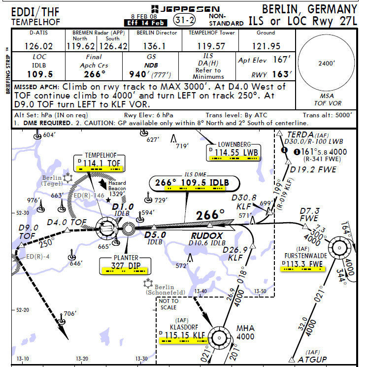
My objection for using GPS DME substitution revolves around the likleyhood of selecting from the GPS database the wrong waypoint with the right ident. As I said a long time ago on this post I have no objection to this practice once the safety case has been made, as you can see from NC Yankees post see by and large in the USA this case has been made buy locating similar waypoint names so far apart that the distance becomes unusable, unlike in the LFAC plate above where the distance between the MK DME and MK NDB make a mis selected GPS distance plausible and almost undetectable.
In short the USA has done the work and mitigated the likelihood of an error with DME substitution and made it a safe practice, Europe has yet to do so, when it does I will be more than happy to use the practice.


