Regarding the DME=0 thing… I didn’t survey the database but I do know that for all “IFR airports” I have a RWYxx waypoint in the database. As example I can talk about is EDDS. See https://www.autorouter.eu/api/pams/id/400000000198944
I select the ILS07 approach and it will end in the RWY07 waypoint and has the published check altitude point as a GPS (it has no name on the chart) waypoint as well. I do get a message that GPS overlays are not allowed but the data is there and while I fly it on needles (turn the avionics from FMS to the NAV receiver) I switch the bearing pointer to source the FMS. That way I can see when I’m passing the unnamed check altitude point (it has a name in the database but not on the chart) and how far I am away from the runway threshold.
There is another detail: I usually keep the speed high (160 kts) when flying an ILS to better blend in with the other traffic and tell ATC that I can hold that speed until about 2 NM from the threshold. I do want to know when I need to slow down hence the RWY07 waypoint does matter to me.
There might be a difference in the database contents depending on the device it was created for. Maybe not all of us are able to see the same. I’m pretty sure that a GNS430 users will see significantly less than a G1000 user due to storage limitations of the GNS430.
Is your RWY07 the MAP or the TDZ, Stephan? You have a G1000, I assume?
Stephan_Schwab wrote:
There is another detail: I usually keep the speed high (160 kts) when flying an ILS to better blend in with the other traffic and tell ATC that I can hold that speed until about 2 NM from the threshold. I do want to know when I need to slow down hence the RWY07 waypoint does matter to me.
Wow, I don’t fly that fast at two miles.
As a follow up it isn’t meant as a criticism but remember not to compromise your own approach too much for ATC. I will normally commit to say 160 until 4 DME. At that point I need to get stabilised as to speed. For example at Brussels you are required to do 180 until 6 then 160 until 4.
I use an Avidyne R9. The RWY07 is the touch down zone / threshold
Anthony Q
You have simply failed to take on board the human factors issues, it is not a case of EASA bad FAA good.
The FAA are as pro human factors training as EASA and when moving to GPS distance they will have looked at the posablities of confusion ( as I discribed above ) and removed the chances of error as far as they could.
EASA have yet to move in the GPS distance direction and will not have looked at places that are likely to give rise to errors.
It is therefore far more likely that a human factors error will result, and if not stopped by checking result in an accident.
It is the failure to acknowledge this risk that is the real flight safety issue here.
A&C, of course you are correct…. my previous response was slightly tongue in cheek as I felt I had to come to the rescue of a fellow carbon-based life-form! We non-military CBLFs tend to bristle when our failures are pointed out so explicitly…. 
A_and_C wrote:
The FAA are as pro human factors training as EASA and when moving to GPS distance they will have looked at the posablities of confusion ( as I discribed above ) and removed the chances of error as far as they could.
And what exactly did they do to " removed the chances of error as far as they could." ?
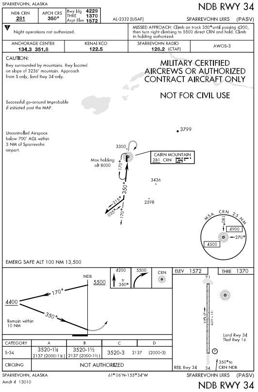
Here’s a great [counter] example of how the FAA “removes the chances of error” :
Nota Bene : " “successful go-around improbable if initiated past the MAP,”
Maybe not the best example but here is the ILS RWY24 at Calais, France.
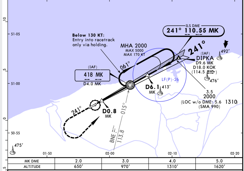
Here the ILS and the LOC/NDB have the same identifier. Can we imagine a scenario where someone does a LLZ (no GS) approach using GPS distance to LOC/NDB MK and starts descending at D10.1 instead of D6.1? Or would one rather use distance from the threshold (waypoint RWY24) which may not be the D0 point?
As anyone who flies IFR will know, there are loads of cases where the same ID is used for a VOR and for an NDB. When loading a route, probably 50% of the routes have such cases, and the GPS queries which one you want.
And they are highly unlikely to be co-located.
It would be interesting which products’ databases contain the “RWY07” type of waypoint mentioned earlier.