
Give me some time to do some more due diligence on that. Skydemon has now tackled the problem with the italian TMAs, so I’d like to have a close look at them and see if they can now be recommended for VFR in Italy.
As a workaround, one can download the current AIP-derived VFR charts from the web. Even better, there is a nice ios app out there called “aip italia” which allows pilots to view the entire AIP on the ipad and also to download selected parts of it (like the VFR charts, see section ENR 6) to the ipad. I know these charts aren’t beautiful, but they’re current and “official”. 
Also, the mentioned changes in the northeast of Italy are all “for the better”, so as long as pilots fly in radio contact with the FIS (which 99% of foreign, visiting pilots do anyway), there is no real risk of busting something, even if flying with outdated charts.
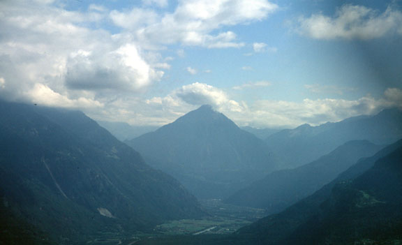
What is the best way to cross the Alps VFR in a plane whose ceiling is say 10000ft?
I know sod-all about what is normally called “mountain flying” – what I call “canyon flying”.
When I was doing this and this and this in 2004 I had a Swiss pilot in the RHS, and on the way back to Wangen-Lachen – I dropped him off in Sion – I followed him back, and my escape route from unavoidable IMC would be a climb straight up and a mayday call (because I would be busting the Swiss Class C) and I had a topo map running on the GPS.
But I wonder what is the best procedure for a lower perf aircraft. Obviously if there is no cloud about it’s easy. Nobody is going to fly into a mountain unless they get lost and end up in a narrow canyon, and/or misjudge the rising terrain in front of them.
Presumably the way to do it most safely is to fly at or above the terrain height. I think there is a route across the middle of the Alps at about 9000ft.
One needs to remember most N European pilots and especially Brits have no experience of mountain flying. And to fly decisively right across the top (as I have always done) requires oxygen. So maybe the best option is to take the eastern route, straight into Slovenia?
Peter, we get mountain training in Switzerland, it’s part of PPL and CPL training. There are several points and I will probably not be able to think about all of them here, but some are:
I just made two training flights to Samedan last week, one in cloudy but calm weather – looked amazing but the airport surrounding was covered with clouds so we had to turn around. Next one was no clouds but wind and turbulence. Absolutely amazing scenery!
I personally find Alps crossing a thing you should respect but in no case fear. Prepare well, ask fellow pilots for advice, be careful and fly over. If you have the possibility, fly a bit higher – 10,000ft should be ok for the crossing, you need only 5-10 minutes at that altitude even with a C172 and if you are healthy you should have absolutely no problems. You are also in airspace E (or sometimes even G if you go below 2000ft AGL) but it is advisable to stay in contact with Zurich Information 124.700.
I wish you all nice Alps crossing and will try to help anyone who needs information about that
In fact, I do understand that people without training in the mountains should be a bit careful the first time they do it.
But on the other hand, if someone is coming all the way from say UK on a unique trip, with the Alps on his track, it would be more than wrong to say “oh, better go all around them, ideally via Hungary, that’s easier.”
At that point, easier to stay in bed. Private flying is about experiences and – to certain degree – about taking and mastering challenges. And crossing the Alps is one of the most beautiful ones.
Everyone should make his own decisions. Always.
@boscomantico: agreed
It has to be said though that, from the UK, the route via the eastern (less high) bit of the Alps (a bit like this but even further to the east, over the Alps) is closer to the GC route than the route via SRN which I posted above.
The rectangular map projection used in most flight planning apps is misleading.
The SRN route just has the advantage of being above any “mountains” for the least time, and that is an advantage.
Can somebody post a suggested VFR route which requires the lowest altitude capability and which goes somewhere around the middle? Your Swiss chart link, Avenger, doesn’t work for me; it says “do not hot link”. It might be better to upload it or a screenshot of it to imgur.com.
VFR: Gotthard, which is essentially the same as the IFR route using N850, is quite straightforward. But nothing beats the Brenner if one doesn’t want or can’t climb much.
That’s strange, Peter. It works for me in all browsers.
Anyway, here is a cropped version of the map. I marked some routes (some of them are also marked on the map itself, I just highlighted what you can see on it).
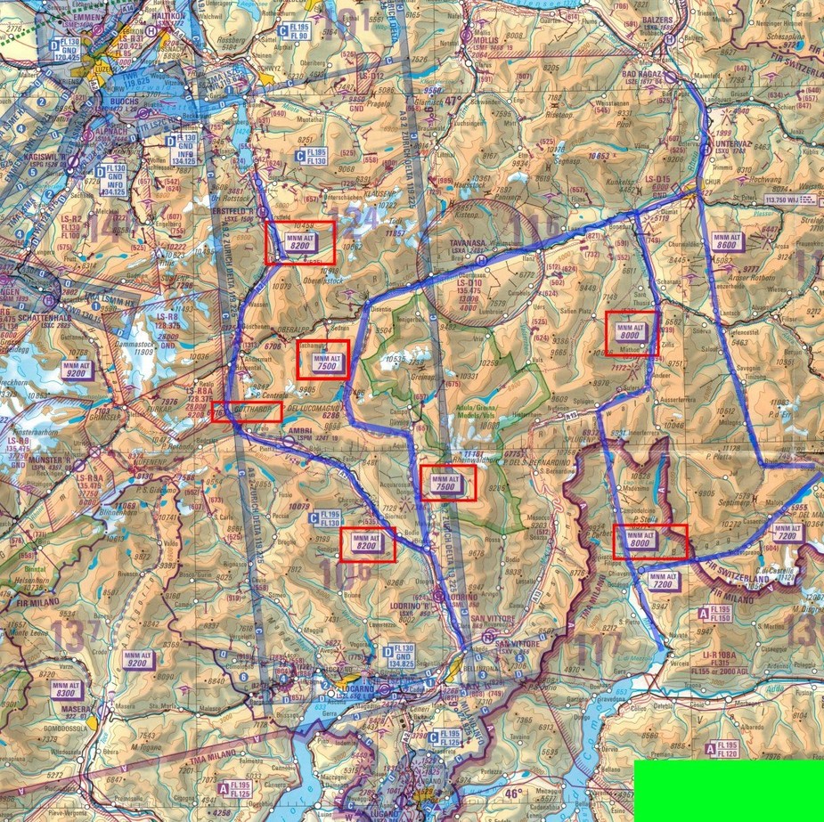
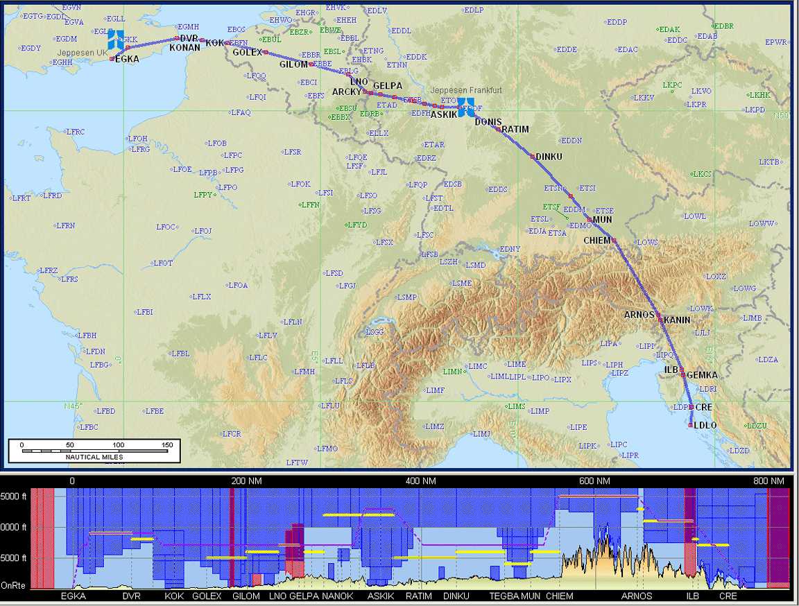
Let’s say you refueled in EDMA/Bavaria a good routing that is not too high is DCT VIW VOR-ILB VOR-CRE NDB-LDLO. There’s two high points, the first crossing the central Alpine massif abeam Mauterndorf (have no map with me at the moment, travelling) and the next one into Slovenia after VIW VOR. From there it’s only downhill. I would fly this routing 20 years ago as a beginner, and if the clouds are not overcast or too high i would fly on top in FL120 for the highest part.
When this was not possible then i would fly further east then check where i could turn south (gets lower all the time twds Vienna) and then turn South twds Graz. Then you still have to cross one higher range into Slovenia but that’s no problem most of the time.
About Brenner: When the clouds are really low and you follow the Brenner Autobahn very low then there’s one pount (Bosco, before Bolzano?)!where you almost have to fly a steep turn around a mountain.
Another route is the VFR corridor from Villach to Udine, there’s evern a chart for that. You can fly along the highway pretty low. Very spectacular, and i would only do it in a slower plane. But it’s pretty safe and can be planned well


