Peter wrote:
However it does suggest the flight was in IMC or mostly IMC at the time the turnaround was commenced, because if you were flying in reasonable VMC you would not turn around into a place where you just flew past a mountain. And at 6500ft there were peaks everywhere around.
This is precisely the kind of situation that a good VFR nav app with terrain could save your live. Reading VFR into IMC or CFIT accident reports from Norway (similar terrain), they all are essentially the same, VFR or IFR, makes no difference. It’s one of two. The pilot decide to deviate form the planned course/alt due to poor visibility or as a panic reaction – and bang, or he gets trapped beneath clouds and raising terrain.
Also, it is very different to put your life at the mercy of an app in an everyday situation (flying VFR in IMC, which is a very bad idea to start with, terrain or not), and to trust that capability only to get out of an emergency situation where you have nothing else.
With this accident, I’m not so sure. He probably believed (wrongly) he was clear of terrain by the looks of it? In that case why? – or it was more of a panic reaction. I mean, why make a turn below mountain tops in IMC? Either way he was confused about his alt and/or position.
Is the crash position known now? Would give some indication where the decision to turn was made…
They probably meant the ELT.
I doubt it because the press reports said the ELT signal was used to locate the wreckage.
This is precisely the kind of situation that a good VFR nav app with terrain could save your live
All tablet discussion into the other thread please. I have already moved 2 pages of it… and that thread shows some real pitfalls of certain popular apps.
Peter wrote:
All tablet discussion into the other thread please. I have already moved 2 pages of it… and that thread shows some real pitfalls of certain popular apps.
I understand that Peter. I also think everyone start to see the facts here, even though no one states it. This was most probably a controlled flight into terrain in IMC flying “IFR” – unless of course there were some engine related malfunction. SERA 5015 b 1 states that in mountainous terrain, the minimum alt is 2000 ft above the highest point within 8 km from the current position of the aircraft. In the vicinity of Albertville, the minimum IFR alt would be at least 10142 ft. They flew at 6500 ft, and with mountain peeks at 7-8000+ ft all around. The investigation will most probably simply point out that very fact (unless some engine related stuff is found), and that will be the end of it, no further investigation necessary. I understand Albertville is VFR only, and this means the airspace all the way up to 10142 feet is VFR only. They were essentially flying VFR in IMC for a long time, over long distances.
LeSving wrote:
They were essentially flying VFR in IMC for a long time, over long distances.
We can’t know that. Maybe there were enough holes in the cloud cover during their descent. Maybe the clouds were layered and broken and gave them a good enough view at the terrain. Until they came across the bottom layer at 6500ft which was solidly overcast. If the plots in the first posting of this thread are accurate then they descended at near constant rate most of the time and levelled off for a minute or two. If their intention really was to fly “IFR in IMC”, why did they not just continue down all the way? Why level off there?
If I try to put myself in the pilot’s mind, then (as I previously wrote) why level off at 6500ft (as per the FR24 data).
I reckon that “6500” on that French SIA map was used. I have read hundreds of accident reports but have seen very very few accident reports where I thought “I could have done that” (because most people kill themselves doing really dumb things). But this one resonates – along with the “Swiss ICAO” chart of 2004 which was another death sentence for anybody finding themselves in IMC (for whatever reason).
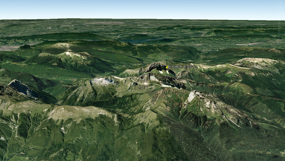
Is the crash position known now? Would give some indication where the decision to turn was made…
I am sure a local can identify it from google earth etc. Also sometimes people leave EXIF data in images so that’s worth looking at. I have just looked at that crash site pic and there is no EXIF there but maybe the source image has? @Manfred might be able to look.
This was most probably a controlled flight into terrain in IMC flying “IFR” – unless of course there were some engine related malfunction
That’s obvious. Nobody flies into terrain in VMC – box canyons and such excepted.
The crash position has been known since the first newspaper articles – east face of Mont Trelod.
Note how an easterly impact does neither match with the last FR24 position nor with the famous 6500 level off (they would’ve crashed into rock way before that).
Now how do we reconcile the crash site with the FR24 LKP and a 6500 flight altitude?
Is that a helpful comment or your more usual ironic/sarcastic one, Shorrick?