Peter wrote:
The only one which is crappy enough to make somebody think 6500ft is OK is the French SIA one.
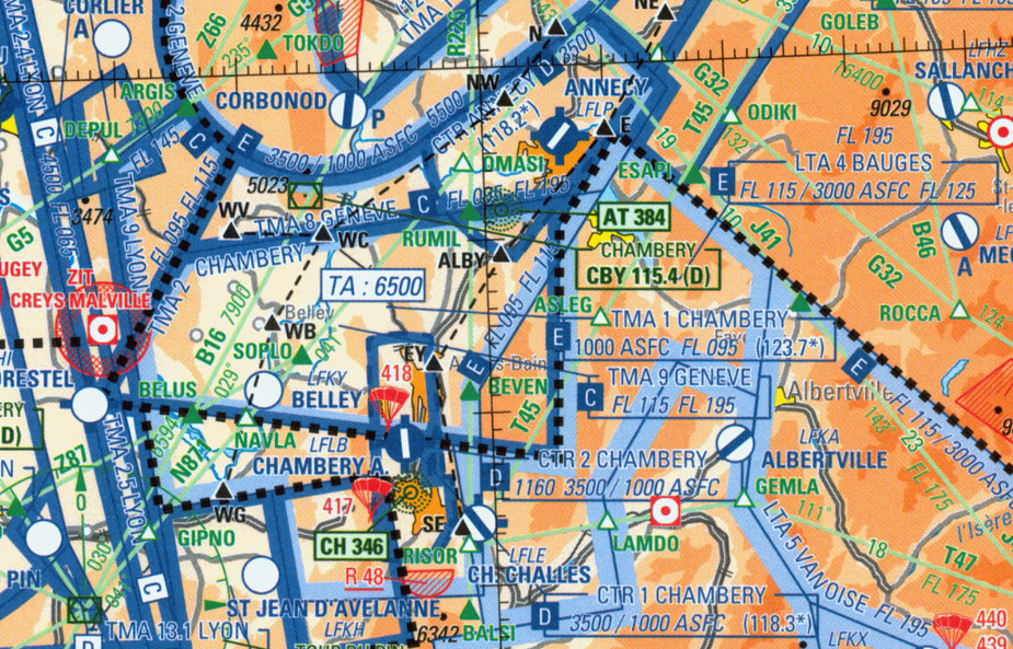
I’ve read this thread from the start and looked at the chart in question, but I really can’t understand why the “TA 6500” note would make someone think it would be “ok” to fly at 6500 feet. Can you explain the reasoning?
Peter you know Swiss charts have shown quadrantal MSA in feet for a few decades now :-)
Yes, but one may not be looking for those numbers.
For example the UK teaching is to look for spot elevations 5nm either side of planned track. If you look at the SSA then you end up much higher, due to some tower 10 miles away.
Same with the US PPL. Never looked at SSAs. What does Germany teach?
Also there is this – see page 20. Not all maps show the SSAs the same way. So using the spot elevations is much smarter – unless you are in a total hurry and then taking the SSA and adding 1000ft is reasonable… but then where is the SSA here:
That chart is unreadable.
Can you explain the reasoning?
Not sitting in an armchair while reading the map.
Yes, it seems this one event where a Human Factors lecture is also in order….
Can you be more specific in your analysis?
Peter wrote:
“Yes, it seems this one event where a Human Factors lecture is also in order….”Can you be more specific in your analysis?
Unless there was a catastrophic mechanical failure – which we can’t rule out I suppose, then by definition this is pilot error…. this topic has raised many issues related to Human Factors including how a pilot can potentially misinterpret a chart… or be fixated in getting to the low ground (or water in this case)…or fail to have a reasonable escape plan….
Airborne_Again wrote:
I’ve read this thread from the start and looked at the chart in question, but I really can’t understand why the “TA 6500” note would make someone think it would be “ok” to fly at 6500 feet. Can you explain the reasoning?
Only talking for myself (but with similar background to the accident pilot: trained in Germany and accustomed to German VFR maps and Jeppesen IFR maps): I have never ever come across one of these French “SIA” maps. The few times I flew VFR in France I used either the Jeppesen VFR maps (which no longer exist AFAIK) or a different French map. I have never before, in over 30 years of flying, knowingly used a VFR map which has transition altitudes printed on it. For me, altitudes shown on a map at unspecific locations are “grid MORA” type minumum safe altitudes. So probably I would have fallen in the same trap here, had I flown VFR in IMC and using that map.
Peter wrote:
That chart is unreadable.
Isn’t that the SIA 1:1.000.000 chart? In that case it is totally unsuitable for that kind of navigation.
Here is the French IGN chart:
I am surprised there is no grid altitude indicated…
In that case it is totally unsuitable for that kind of navigation.
Well, yes, but as I wrote further back in the thread, complete with a screenshot of the SIA shop with “VFR chart” and “French Republic” all over it……. historically foreign pilots used this chart for the various reasons given.
what_next wrote:
For me, altitudes shown on a map at unspecific locations are “grid MORA” type minumum safe altitudes. So probably I would have fallen in the same trap here, had I flown VFR in IMC and using that map.
Ok, that makes sense.
Thought:
Might it be that all those maps focus on airspace structure to indicate to VFR pilots which areas to stay out of or when to ask for permission to enter? They are not really to be used for terrain avoidance as per definition a VFR pilot is supposed to look out of the window for that and use the eyes.
IFR pilots who happen to fly in IMC require data to avoid terrain but don’t care much about airspace structure. So something like a minimum safe altitude per grid is helpful for IFR pilots but not deemed necessary for VFR pilots.
Peter wrote:
historically foreign pilots used this chart for the various reasons given.
Who plans a route through the mountains on a map with no altitudes shown?!
I really think that until shown otherwise the coincidence between the 6500 on FR24 and a number 6500 on a chart that we have no evidence he had or was using is being stretched a bit here. I refuse to believe he was using that chart for a VFR arrival in the mountains.
Based on the quote from the police earlier it seems there was no evidence at this stage of mechanical error and so perhaps really just a pilot winging it in mountainous terrain. On the chance he misread a chart it all comes back to proper planning on the ground and then correct airborne decision making. As Anthony says, a human factors and ADM problem.