
Peter wrote:
I can’t match it with the pic in post 30However the coordinates below were posted today on FB by someone, on Stefan’s account
That matches to me. The photo is just taken from a lower angle.
You think those new coordinates are probably right, Jason?
Now somebody needs to extend the FR24 track. I was not able to get the KML etc files from FR24 – I think it needs a paid membership. I have the FR24 android app which works quite differently and offers real time tracking only, with no logs of any kind.
Peter wrote:
Is that a helpful comment or your more usual ironic/sarcastic one, Shorrick?
As a matter of fact I am just done reading Daniel Kahneman’s “Thinking, Fast and Slow” – which I highly recommend – where he disserts upon how the human brain is wired to build a narrative from discrete information points that may or may not be related.
Case in point – in case you missed it over the last pages – the repeated storyline of how the pilot flew at 6’500 ft based on two discrete and unrelated data points i.e. the last altitude datum (unrelated to crash datum – see map) stops at 6’500 ft and the map says 6’500ft.
So coming full circle to helpfulness vs. sarcasm, I was wondering how helpful it is to repeat it over and over in spite of the lack of casual or factual evidence (sort of like the SR22 reverse – airflow – icing). Or questioning the official police crash site datum because the newspaper photo doesn’t match the GoogleMap perspective.
Kahneman and Tversky should be in the ATPL syllabus – especially on what constitutes expertise, or expert intuition.
The only press figure I have seen for the crash site is 1700m, which seems a rather “round figure” and if correct (5400ft) would suggest a further descent was made, from the 6500ft which the FR24 tracks ends with (in a level portion) and this descent was possibly during the turn back.
There is quite some distance flown from he fr24 track to the scene of the crash. Only further track and altitude info from ATC radar will shed light on this.
Another scenario would be the classic “wrong turn”. The route from the last known position to the airport woukd go over the lake and follow the valley, with a sharp bend to the right further down – this could be him taking a wrong turn, ending up in this valley, trying to turn around.
Accidents like this can happen in VMC, too. It will be some time until we find out what the most plausible one is.
The last FR24 position shows him flying eastbound towards a VRP halfway down the lake of Annecy. It is also quite common, also on cloudless days, to fly at around 6 to 7000 feet altitude through the valleys.
Assuming that he attempted to reach Albertville but then turned around after concluding that a landing there was not possible, he might have ended up at the crash site.
@Peter: I have a subscription to FR24, so if there is something I can download, let me know and I can do so tonight when back home
Thanks for your offer Aeroplus but since 7 days have elapsed, FR24 has removed the track AFAICS
We have this (from earlier in the thread) which can presumably be plotted reasonably well by examining the contours
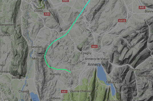
and that track ended with a flat (and possibly straight, looking at the above) portion at 6500ft.
The track is still available to me as I have the paid subscription and therefore it is not removed after 7 days, but what would be new to what is already posted above? I checked before leaving the house and quite a lot of his flights over the last month’s are still there.
The 3D track (KML etc) would be useful to see, I think.


