I run Skydemon and/or JeppFD continuously, sometimes switching to the ADL satellite data app for weather updates. Skydemon is miles better for OCAS VFR or IFR work, but for ‘system IFR’ I dont think there’s much to differentiate them.
What would be nice on a tablet would be a continuously updated glide range “circle” but it’s hard to do accurately because there is no wind data.
Skydemon does exactly this using forecast winds (which it updates before the flight). Its not perfect – but IME (I’ve tested it from 4000ft a few times) is pretty close.
I consider the panel mount GPS to be the autopilot command center, nothing else
That, and it updates the fuel totaliser.
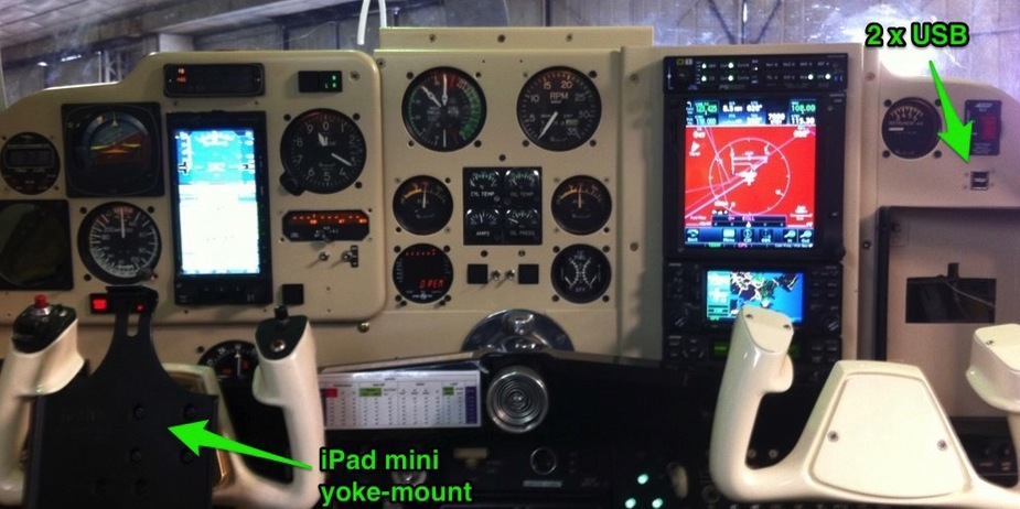
We can’t charge our iPads in flight
I’m just redoing my panel and I’ve had six USB sockets installed. Two on the panel, two on the floor between the front seats and two in the rear cabin.
Skydemon does exactly this using forecast winds
Does it also take terrain into account? I’ve implemented this some time ago, but I’m not using it very often, it takes quite some computational time, and the results are just too depressing 8-)
Does it also take terrain into account?
Yes
Does it consider changing winds through the descent? For example from 280 the glide range ring is pretty complex to calculate.
Does it consider changing winds through the descent?
No idea – will email them and ask.
There are so many potential complications to that.
For example, imagine the range in mountainous terrain. You might be able to glide many miles and reach terrain that’s at 500ft AMSL, but a direct path might take you through a mountain. But you can go around it. That is something that is incredibly difficult to display.
Of course forecast winds (probably forecast 6 hours or more ago) will also be a lot different to reality.
These inaccuracies are one reason that we don’t bother with that in EasyVFR. Computational time, and clutter being the other two important ones. Instead we do dynamic terrain shading, which colours the terrain based on your altitude. Normal map colours then you’ve more than 1000ft terrain clearance. Yellow, you’ve more than 500ft terrain clearance (but less than 1000ft), and red you’ve less than 500ft clearance, with various shades along the way.
I’m remember being quite happy at one particular point last year to know that we’d more than 1000ft terrain clearance in all direction.
SD obviously think this is a good feature too, as they copied it last year. ;)
Colm
I’m remember being quite happy at one particular point last year to know that we’d more than 1000ft terrain clearance in all direction.
SD obviously think this is a good feature too, as they copied it last year. ;)
You both copied it from Garmin!
As dublinpilot says, this can’t possibly work usefully using forecast winds, except on a relatively calm day.
For example I have seen actual winds of 70kt against 30kt forecast – at say FL150. In some weather patterns, a small lateral movement of the track will pick up a very different wind speed. For example, here, a 50nm E-W movement near Nice would give you a ~50kt wind difference
The next best thing which is nice on a tablet is a proper shaded topo map. I have this running under Oziexplorer, for the Alps and the Pyrenees. It is for overflying mountains above an overcast  The data was generated using Mobile Atlas Creator, which ripped it off Google Terrain. I have about 5GB of this stuff… But it runs only under Windows or Android
I still don’t know what use is a tablet under IFR for navigation related tasks…
I still don’t know what use is a tablet under IFR for navigation related tasks…
Orientation and picking good waypoints when asking for shortcuts. I do all map stuff on the tablet, the builtin GPS just feeds the autopilot.
The next best thing which is nice on a tablet is a proper shaded topo map. I have this running under Oziexplorer, for the Alps and the Pyrenees.
I have this information as part of Aspen’s synthetic vision and also on the tablet but with lower resolution.