
Is there anyone with access to Biggin Hill who would be willing, for money, to train me on Garmin Pilot itself, plus how it is supposed to interface with GTN via Flightstream/Connext?
It is driving me quite potty, it does not seem to work in any sensible way. I just revert to JeppFD and SkyDemon because I am so frustrated at GP not working for me.
(Please don’t assume this is 101; I am pretty good with both iOS apps and avionics, but there is either something not working or something I am fundamental missing about the paradigm.)
The issues include:
As I say, I am not an idiot, and I am far from a Luddite, but as things stand for me, the whole Connext/Flightstream/GP investment is a hugely expensive pile of junk.
A few thoughts on your bullet points:
Use Autorouter through GP. (An option under Create Trip). Uploading/copying plans from other apps often brings issues. If you get the wrong “N20”, select the waypoint and you get a “which waypoint option”. I occasionally get the issue but not irritatingly so.
Uploading to GTN – I’ve never had a problem. Software version mismatch?
You’re stuck with Flightcharts I’m afraid – it’s the default.
Stacking charts – an irritant. The only app I find that is really good here is ForeFlight
Jep enroute chart overlaps should be seamless, it is on mine. Subscription issue?
Downloads – I just leave mine on auto.
Finally, I’ve been playing with ForeFlight over the last few weeks; I’m mighty impressed.
Dave,
Thank you. I will try launching autorouter the other way round to see if it does any better. Does it still give all the benefits of Telegram etc?
On the uploading from autorouter the way I have been doing it, I am fine with how to fix the issues as they arise, but I find the stupidity of the programming extremely irritating.
If you have got as far as ABB, which has an airway leading out of it called N20, in what world of programming or QA would you think that the user obviously meant the other N20, literally the other side of the world in the South Pacific?
Similarly, if you are going from B3 to H9 via REM why would you look at the range of REMs available, an RNAV waypoint, a VOR and an NDB, and choose one (the RNAV waypoint) which does not link B3 to H9 when another (VOR) does?
We are used to Garmin being a quality oriented supplier and their programmers have really let them down here.
I don’t know where to go on the GTN upload/download issues. I am using 6.41 on the GTNs and the latest GP. All the versions reported by the GTN look correct, according to the Garmin SB.
Part of my problem is that the opportunities to interact with the system are constrained. Either I have to drive an hour each way and arrange for it to be pulled out of the hangar (for GPS and iridium) and hooked to ground power, or it is part of a scenario where the owner gives me very little notice of his requirements so there just isn’t time for experimentation and for things to go wrong, so I just jettison the aircraft’s iPads and revert to my own, with JeppFD and SkyDemon, which I know and trust. I find myself programming the route on the taxi out, or even airborne, which ain’t great single crew.
Timothy,
I’ve just tried to replicate the N20 error, and I don’t get that, even if I turn off the “auto resolve waypoints” feature in the “flight plan” subsection of the “general” setting page. I have a Europe sub but the Marshall Islands N20 point is in my database so the potential for confusion is exists.
The fpl transfer works perfectly well in my install, as it does for Dave.
I like Foreflight very much too but I’m now hooked on Database concierge.
How often are you in the EG TF, as opposed to the LF one? Perhaps I could bring the Chieftain there and we could have a play? Unless KB is also accessible to you?
Timothy wrote:
Cannot eliminate Flitecharts from GP – I only want Jepps
Did you uncheck HOME-JEPPESEN-CHARTS-Display FliteCharts and Jepp Charts?
Dave_Phillips wrote:
Use Autorouter through GP
Absolutely. This solves some issues with copying. But AFAIK you will not keep the Telegram functions.
denopa wrote:
I’ve just tried to replicate the N20 error, and I don’t get that
+1
Dave_Phillips wrote:
Jep enroute chart overlaps should be seamless
What do you mean? There are not jepp Enroute charts in GP, no?
Flyamax wrote:
Did you uncheck HOME-JEPPESEN-CHARTS-Display FliteCharts and Jepp Charts?
I don’t have a HOME-JEPPESEN, I only have a HOME-CHARTS. Is this part of the problem?
Ah. I have found HOME-SETTINGS-JEPPESEN-Display FliteCharts and Jepp Charts, and switched it off, thank you.
I have bought Jepp enroute charts in GP and sometimes they appear, sometimes they don’t. No logic that I can make out.
If I go HOME-SETTINGS-JEPPESEN-Jeppesen Charts Download I see
CHARTS
Europe IFR
Cycle 25-2017 Issue Date: 15 DEC 2017
Valid to Dec 29, 2017 – 150Mb
But I can’t find how to consistently make them show. For this I paid £120, incidentally.
But none of this is my main concern with GP. My main concern is that every time I go to use it, something goes wrong (or at least WIDN) and I give up. That is why I need training.
This isn’t helped by a distinction between Maps and Charts.
I mean, WTF?
Select IFR Low
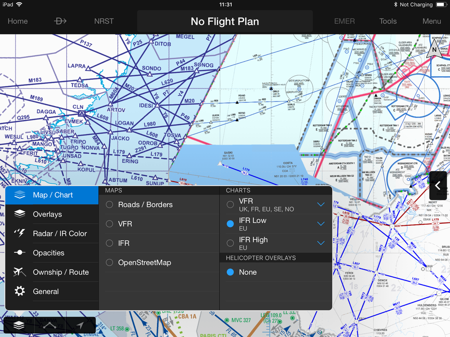
and you get what I think are the AIP charts, so all different
Select Maps IFR

and you get what I assume is the GP IFR map
But nowhere do I see how to select the Jepp chart
I’m at EGTF in the winter and will be back from my break early Jan. Happy to meet there.
On the Charts IFR, what appears when you press the blue down arrow to the right?
denopa wrote:
On the Charts IFR, what appears when you press the blue down arrow to the right?
It just says Europe with three horizontal edit bars. I guess to allow you to reorder if you have worldwide coverage.


