
Peter 24-Mar-20 08:24 160
I am all for FF making good progress. One of the reasons is listed in the “threads possibly related” below i.e. this FF has a great product, but IMHO they won’t be successful if they charge a price approaching or equalling RR for full autorouting functionality. It is indeed excellent that FF has a presence on EuroGA.
For IFR in Europe I have never needed an “EFB”, and have no room for anything with a big screen in my plane anyway (TB20). During a flight I run VFR charts for emergency and general interest reasons, and for CAS avoidance when I fly VFR in the UK, on an old tablet.
Hi Peter,
Foreflight performance plus is £239 for Europe, there are no restrictions on flight levels or aircraft types unlike piston, turboprop, business etc. The included performance models are incredibly accurate from a C150 (for example) up to the largest commercial jets. ALL aspects of fight planning are excellent, not just the autorouting capability – this in itself is a tiny part of the capabilities, it’s included, they do not charge anything extra, it’s not an add on.
Sorry Peter I have to say you seem doggedly determined not to embrace any efb’s capabilities. Back in the day I’ve flown around the world many times using basic long range nav – INS/IRS, VOR, DME, ILS, NDB and paper charts. I’ve also used all the improvements as they’ve come along and each and every one has been a step forward, improving planning, situational awareness and safety. Could I still get to the other side of the World/Europe/local VFR bimble without an EFB? absolutely. Would I choose to? absolutely not.
I know the TB20 series is a bit snug, has nobody found a suitable way to mount an iPad mini?
BerlinFlyer wrote:
No offense meant to anybody, but I can’t understand why people complain about pricings of programs like ForeFlight or SkyDemon, especially in the aviation community.
No offense taken and for the record I totally love FF and use it extensively, I just don’t like paying for things or services I don’t need. Guess I’m more of an ‘a la carte’ than a ‘buffet’ guy ;-)
Xlr8tr wrote:
ALL aspects of fight planning are excellent
Please don’t exaggerate. AR delivers all aspects of flight planning (including much better IFR routing) in better and more useful form. From weather, NOTAMs, to fuel planning and W&B. I’ve been using FF since it started to provide support for Europe and I admit they are progressing but let’s be realistic.
Emir25-Mar-20 04:09 167
Xlr8tr wrote:ALL aspects of fight planning are excellent
Please don’t exaggerate. AR delivers all aspects of flight planning (including much better IFR routing) in better and more useful form. From weather, NOTAMs, to fuel planning and W&B. I’ve been using FF since it started to provide support for Europe and I admit they are progressing but let’s be realistic.
AR?
Auto Router?
chflyer wrote:
A quick question for you @Josh_Tahmasebi_ForeFlight, is there a way to get standalone DMEs to show on the map page?Specifically, WFJ 113.750 in Switzerland can be found with a search and added as a waypoint, but does not appear on the map nor does it appear in the “Add to Route” box if one touches the map. It does appear on the Swiss ICAO chart.
Hi @chflyer,
Not yet, however we do have an open case to separate the airways, navaids, and waypoints from each other so you can enable/disable independently. I will see if I can get the priority pushed up on that one. We know the fix for it so it’s a matter of getting it into the rotation :).
Thanks,
Josh
Hi Josh,
On your point above, to be able to display the waypoints without airways would indeed be incredibly useful.
Base map – I applaud your efforts to improve the basemap, keep them coming. However having looked over (again) the optional VFR charts for Europe (raster images, no decluttering, no common standards across borders, and no trial period – ridiculous at the prices charged) I think you’ve still got a long way to go before Foreflight comes close to the same VFR functionality as its main (VFR) competitor here in Europe.
To that end I believe you need to include the following in the basemap, vector based, individually selectable and zoom based decluttering.
Surface Features
Roads – not the current street map available only when online
Railways
Geographical names
Urban areas
Trees
Road names
Rivers
Maximum elevations and sector safe altitudes
Airfields
Glider airfields – too many missing from the map, the risk of cable collision doesn’t bear thinking about
Disused airfields – still a lot of old airfields used for VFR navigation here in the UK.
Identifier/name – ability to display either or both
Waypoints
Radio aids
VRP’s
Airways waypoints
Towns – clearly defined and named
This should be more straightforward than it appears as most of these can be done by an automatic process as used used by other cartographers, including SkyDemon.
Please take this as feedback rather than criticism, the pace of development has truly been impressive.
Hi @Xlr8tr,
I appreciate your feedback. We are aware of missing fields that do not have codes and are working on a solution for that as well currently. That should allow any airfield, microlight, glider, etc field + helipads/heliports to show on the aero map. We also have an ongoing project to replace our existing set of place labels to improve decluttering and increase the number of place labels so items are both better prioritized and smaller towns/villages/hamlets show on the map.
Just a quick note on the “Surface Features”: Did you know that you can do this today by going to the map settings (gear icon)? From there you can make base map selections under both Terrain and Cultural Elements. The buttons that show on the side when the aeronautical layer is enabled for terrain and basemap will also respect the settings you choose.
All the best,
Josh
Josh_Tahmasebi_ForeFlight 27-Mar-20 13:26 172
Hi @Xlr8tr,
I appreciate your feedback. We are aware of missing fields that do not have codes and are working on a solution for that as well currently. That should allow any airfield, microlight, glider, etc field + helipads/heliports to show on the aero map. We also have an ongoing project to replace our existing set of place labels to improve decluttering and increase the number of place labels so items are both better prioritized and smaller towns/villages/hamlets show on the map.
Just a quick note on the “Surface Features”: Did you know that you can do this today by going to the map settings (gear icon)? From there you can make base map selections under both Terrain and Cultural Elements. The buttons that show on the side when the aeronautical layer is enabled for terrain and basemap will also respect the settings you choose.
All the best,
Josh
Hi Josh,
Yes fully aware of those options, still not enough base level detail though – two images of the same busy area, both programs have all the ‘cultural elements’ turned on.
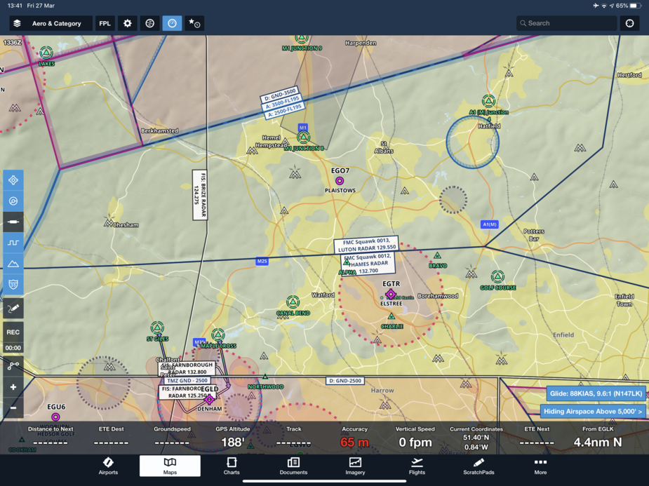
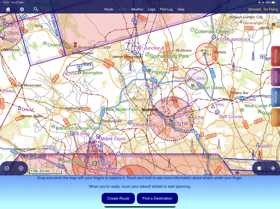
Understood. I appreciate the feedback and we will see what we can do in future releases. The biggest takeaways from the screenshot of SkyDemon that are not already in progress: Transmission lines, more road labels, and zoom level differences. I’ll capture the feedback and we will see what we can do.
Thanks again,
Josh


