
Sebastian_G wrote:
And on top the first download of the flight will be the biggest due to data compression.
Could one not achieve the same thing by: while still on the ground, disable wifi on the client device, forcing it to use 3g/4g, start the ADL app, do a single download, then re-enable wifi?
I do that (disable wifi on the phone) frequently in flight when I want to send/collect messages. In normal VFR around the UK there is 3g/4g nearly all the time, I don’t need the ADL, so one can message, read EuroGA, get tafs/metars/etc over telegram or via some private site, etc  With wifi enabled the phone has no connectivity whatsoever because it connects to the ADL’s wifi which takes precedence over 3g/4g, and it doesn’t realise there is no internet connection
One could achieve the same thing by pulling the ADL CB but I reckon it would eventually wear out.
IMHO the ADL app needs a feature which gives you a much simpler user interface for getting just tafs and metars. Currently you have to config the airport codes and do a download – many keystrokes.
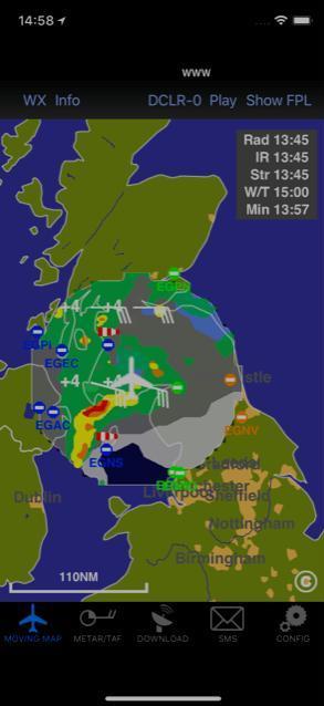
@Sebastian, it seems more than a bit cheeky to winge about a free app, but I’ve noticed that the moving map on an iPhone lacks some features of the same on an iPad:
1. No way to select altitude for wind and temperature.
2. No way to filter display of Radar/Infrared/Strike/Wind/Temp.
There is some unused (black) area at top and bottom of the iPhone screen which could be used for this – here’s a screen shot to show what I mean:
@Sebastian_G the 200 does not receive the free weather and rebroadcast traffic in the US ADS-B system correct? Only direct 1090ES traffic?
Jacko wrote:
I’ve noticed that the moving map on an iPhone lacks some features of the same on an iPad:1. No way to select altitude for wind and temperature.
2. No way to filter display of Radar/Infrared/Strike/Wind/Temp.
Press on WX and you’ll find the missing features that I suppose Sebastian has moved there due to the lack of real estate.
Thanks!!
I do that (disable wifi on the phone) frequently in flight when I want to send/collect messages
In fact there is probably an easier way. At least on iOS if you configure the IP address manually you can leave the gateway/router field empty and then the operating system knows there is not internet connection on this WiFi and will use the cellular network if available.
disable wifi on the client device, forcing it to use 3g/4g, start the ADL app, do a single download, then re-enable wifi?
Yes that works but many pilots just have WiFi enabled iPads and the 4G build into the ADL200 is a lot more flexible. I can control when it logs into which network. So it can be a lot more aggressive on network searchs than other devices. I also have special SIM cards which can use for example in Germany use all networks while most normal cards just work with their home network. Also the ADL200 can work on the LTE all the time and maybe fetch some data eventually while the iPad might be switched off by the user.
There is some unused (black) area at top and bottom of the iPhone screen
Unfortunately that black area is only available on the iPhone X. The app is supposed to be compatible with anything down to an iPhone 4s so those controls had to go into a menu behind the “WX” button.
200 does not receive the free weather and rebroadcast traffic in the US ADS-B system correct? Only direct 1090ES traffic?
Yes the ADL200 is 1090ES only so it will not receive any UAT ADS-B. If against all belief UAT will happen on a large scale in Europe I will probably have to change the ADS-B chip and also receive UAT but that would drive up the cost of the device further which I try to avoid.
I might be overlooking this, but where is the AHRS information visualized?
The ADLconnect app will show an insert like this one:
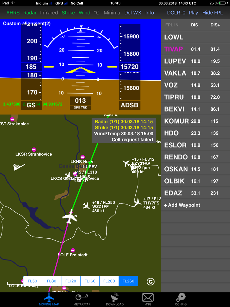
Where is the IAS and altitude derived from? The speed must be GPS GS and the altitude must be GPS altitude.
Since the AHRS looks like it is sensing the gravity vector too, the box will have to be carefully mounted, with the aircraft jacked up, levelled, etc.
Does the android app do this too? (I am staying with my ADL150 – just curious )
Peter wrote:
Where is the IAS and altitude derived from? The speed must be GPS GS and the altitude must be GPS altitude.
According to the legend the speed tape doesn’t show IAS but GS. The altitude tape shows ADS-B altitude which is pressure altitude.


